
"कीवू झील": अवतरणों में अंतर
Content deleted Content added
No edit summary |
Sanjeev bot (वार्ता | योगदान) छो बॉट: वर्तनी एकरूपता। |
||
| पंक्ति 1: | पंक्ति 1: | ||
{{Infobox lake |
{{Infobox lake |
||
|lake_name = कीवू झील<br><small>Lake Kivu</small> |
|lake_name = कीवू झील<br><small>Lake Kivu</small> |
||
| image_lake |
| image_lake = LakeKivu satellite.jpg |
||
| caption_lake |
| caption_lake = अंतरिक्ष से झील का दृश्य (काली लकीर अंतरराष्ट्रीय सीमा है) |
||
| image_bathymetry |
| image_bathymetry = |
||
| caption_bathymetry = |
| caption_bathymetry = |
||
| location |
| location = |
||
| coords |
| coords = {{coord|2|0|S|29|0|E|type:waterbody|display=inline,title}} |
||
| type |
| type = [[दरार (भूविज्ञान)|दरार घाटी झील]] |
||
| inflow |
| inflow = |
||
| outflow |
| outflow = रुज़ीज़ी नदी |
||
| catchment |
| catchment = {{convert|2700|km2|sqmi|-2|abbr=on}} |
||
| basin_countries |
| basin_countries = [[कांगो लोकतान्त्रिक गणराज्य]], [[रवाण्डा]] |
||
| length |
| length = {{convert|89|km|abbr=on}}<ref name=Columbia>[http://www.bartleby.com/65/ki/KivuLak.html Kivu, lake, Congo and Rwanda], Columbia Encyclopedia, Sixth Edition. 2001-05.</ref> |
||
| width |
| width = {{convert|48|km|abbr=on}}<ref name=Columbia/> |
||
| area |
| area = {{convert|2700|km2|sqmi|-1|abbr=on}}<ref name=Columbia/> |
||
| depth |
| depth = {{convert|240|m|ft|0|abbr=on}} |
||
| max-depth |
| max-depth = {{convert|480|m|ft|0|abbr=on}} |
||
| volume |
| volume = {{convert|500|km3|cumi|-1|abbr=on}} |
||
| residence_time |
| residence_time = |
||
| shore |
| shore = |
||
| elevation |
| elevation = {{convert|1460|m|ft|0|abbr=on}} |
||
| frozen |
| frozen = |
||
| islands |
| islands = इद्ज्वी |
||
| cities |
| cities = गोमा, कांगो<br>बुकावू, कांगो<br>किबुये, रवाण्डा<br>स्यानगुगु, रवाण्डा |
||
| reference |
| reference = |
||
}} |
}} |
||
'''कीवू झील''' (<small>[[अंग्रेज़ी]]: Lake Kivu</small>) [[महान अफ़्रीकी झीलों]] में से एक है। यह [[कांगो लोकतान्त्रिक गणराज्य]] और [[रवाण्डा]] की अंतरराष्ट्रीय सीमा पर स्थित है।<ref name="ref39ruxay">[http://books.google.com/books?id=Ezo5PQAACAAJ The Great Lakes of Africa: Two Thousand Years of History], Jean-Pierre Chrétien, Mit Press, 2006, ISBN 9781890951351</ref> |
'''कीवू झील''' (<small>[[अंग्रेज़ी]]: Lake Kivu</small>) [[महान अफ़्रीकी झीलों]] में से एक है। यह [[कांगो लोकतान्त्रिक गणराज्य]] और [[रवाण्डा]] की अंतरराष्ट्रीय सीमा पर स्थित है।<ref name="ref39ruxay">[http://books.google.com/books?id=Ezo5PQAACAAJ The Great Lakes of Africa: Two Thousand Years of History], Jean-Pierre Chrétien, Mit Press, 2006, ISBN 9781890951351</ref> |
||
23:33, 30 जनवरी 2017 का अवतरण
| कीवू झील | |
|---|---|
.svg) कीवू झील | |
| निर्देशांक | 2°0′S 29°0′E / 2.000°S 29.000°Eनिर्देशांक: 2°0′S 29°0′E / 2.000°S 29.000°E |
| प्रकार | दरार घाटी झील |
| मुख्य बहिर्वाह | रुज़ीज़ी नदी |
| जलसम्भर | 2,700 कि॰मी2 (1,000 वर्ग मील) |
| द्रोणी देश | कांगो लोकतान्त्रिक गणराज्य, रवाण्डा |
| अधिकतम लम्बाई | 89 कि॰मी॰ (292,000 फीट)[1] |
| अधिकतम चौड़ाई | 48 कि॰मी॰ (157,000 फीट)[1] |
| सतही क्षेत्रफल | 2,700 कि॰मी2 (1,040 वर्ग मील)[1] |
| औसत गहराई | 240 मी॰ (787 फीट) |
| अधिकतम गहराई | 480 मी॰ (1,575 फीट) |
| जल आयतन | 500 कि॰मी3 (120 घन मील) |
| सतही ऊँचाई | 1,460 मी॰ (4,790 फीट) |
| द्वीप | इद्ज्वी |
| बस्तियाँ | गोमा, कांगो बुकावू, कांगो किबुये, रवाण्डा स्यानगुगु, रवाण्डा |
कीवू झील (अंग्रेज़ी: Lake Kivu) महान अफ़्रीकी झीलों में से एक है। यह कांगो लोकतान्त्रिक गणराज्य और रवाण्डा की अंतरराष्ट्रीय सीमा पर स्थित है।[2]
दृश्य
-
 झील की पृष्ठभूमि में गोमा शहर
 -
 गिसेन्यी का तट
 -
 मछुआरे
 -
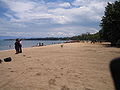
 गिसेन्यी में झील के किनारे
,_Photo_by_Sascha_Grabow.jpg)


इन्हें भी देखें
सन्दर्भ
- ↑ अ आ इ Kivu, lake, Congo and Rwanda, Columbia Encyclopedia, Sixth Edition. 2001-05.
- ↑ The Great Lakes of Africa: Two Thousand Years of History, Jean-Pierre Chrétien, Mit Press, 2006, ISBN 9781890951351