
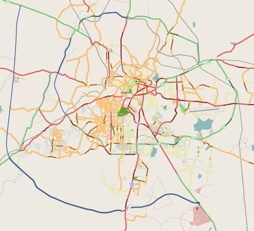
चित्र:Bangalore street Map.png

इस पूर्वावलोकन का आकार: 661 × 600 पिक्सेल। दूसरे रेसोल्यूशन्स: 264 × 240 पिक्सेल | 529 × 480 पिक्सेल | 846 × 768 पिक्सेल | 1,128 × 1,024 पिक्सेल | 1,722 × 1,563 पिक्सेल।
मूल चित्र ((1,722 × 1,563 पिक्सेल, फ़ाइल का आकार: 855 KB, MIME प्रकार: image/png))
|
|
यह फ़ाइल विकिमेडिया कॉमन्स से है। वहाँ पर इसका विवरण पृष्ठ निम्नोक्त है। कॉमन्स मुक्त लाइसेंसों के अंतर्गत उपलब्ध मीडिया फ़ाइलों का संग्रह है। आप भी इसमें मदद कर सकते हैं। |
| विवरण | |
| दिनांक |
३१ दिसम्बर २००८ (original upload date) |
| स्रोत | openstreetmap.org |
| लेखक | Collaboratively created by the OpenStreetMap community using only free map sources and manual GPS surveying to build the map from scratch. Raise lkblr grabbed this image from OpenStreetMap |
| अनुमति (इस चित्र का पुनः उपयोग करना) |
See OpenStreetMap License for details. |
| दूसरे संस्करण | The 'live' version of this map is available at http://www.openstreetmap.org/?lat=12.9536&lon=77.598&zoom=13 Use the 'export' tab to get a fresh export in a variety of formats, including SVG and '.osm', the underlying geolocated data. Use the 'edit' tab there to edit the map! |
सारांश
Latitudes from 77.46 to 77.72
Longitude from 12.83 to 13.06
लाइसेंस
इस फ़ाइल को क्रिएटिव कॉमन्स श्रेय 2.0 साधारण लाइसेंस के अंतर्गत लाइसेंस किया गया है।
- आप खुलकर:
- बाँट सकते हैं – रचना की प्रतिलिपि बना सकते हैं, बाँँट सकते हैं और संचारित कर सकते हैं
- रीमिक्स कर सकते हैं – कार्य को अनुकूलित कर सकते हैं
- निम्नलिखित शर्तों के अंतर्गत:
- श्रेय – यह अनिवार्य है कि आप यथोचित श्रेय प्रदान करें, लाइसेंस की कड़ी प्रदान करें, और अगर कोई बदलाव हुए हों तो उन्हें इंगित करें। आप ऐसा किसी भी उचित तरीके से कर सकते हैं, लेकिन किसी भी तरह उससे यह नहीं संकेत नहीं किया जाना चाहिए कि लाइसेंसधारी द्वारा आपको अथवा आपके इस प्रयोग का समर्थन किया जा रहा हो।
मूल अपलोड लॉग
Transferred from en.wikipedia to Commons by Closedmouth.
The original description page was here. All following user names refer to en.wikipedia.
- 2008-12-31 03:39 Raise lkblr 1722×1563× (789839 bytes)
- 2008-12-30 08:49 Raise lkblr 1656×1019× (632450 bytes) updated
- 2008-12-30 08:34 Raise lkblr 1517×1520× (790374 bytes) from http://openstreetmap.org/
चित्र का इतिहास
फ़ाइलका पुराना अवतरण देखने के लिये दिनांक/समय पर क्लिक करें।
| दिनांक/समय | थंबनेल | आकार | सदस्य | प्रतिक्रिया | |
|---|---|---|---|---|---|
| वर्तमान | 06:32, 20 जुलाई 2012 | | 1,722 × 1,563 (855 KB) | Wantsallanger | enhanced contrast |
| 06:59, 4 मार्च 2011 |  | 1,722 × 1,563 (861 KB) | Raise lkblr | updated completed ring road | |
| 14:47, 24 मार्च 2009 |  | 1,722 × 1,563 (771 KB) | Closedmouth | {{Information |Description={{en|Map of en:Bangalore, India<br/> en:Category:OpenStreetMap maps}} |Source=Transferred from [http://en.wikipedia.org en.wikipedia]; transfer was stated to be made by User:Closedmouth.<br/> (Original text : ''[ht |
चित्र का उपयोग
निम्नलिखित पन्ने इस चित्र से जुडते हैं :
चित्र का वैश्विक उपयोग
इस चित्र का उपयोग इन दूसरे विकियों में किया जाता है:
- af.wikipedia.org पर उपयोग
- ar.wikipedia.org पर उपयोग
- ba.wikipedia.org पर उपयोग
- bn.wikipedia.org पर उपयोग
- বোম্মনাহাল্লি
- ইলেকট্রনিক সিটি
- মডিউল:অবস্থান মানচিত্র/উপাত্ত/ভারত বেঙ্গালুরু
- মডিউল:অবস্থান মানচিত্র/উপাত্ত/ভারত বেঙ্গালুরু/নথি
- বিধান সৌধ
- ডাঃ বি.আর. আম্বেদকর স্টেশন, বিধান সৌধ মেট্রো স্টেশন
- স্বামী বিবেকানন্দ রোড মেট্রো স্টেশন
- বাইয়াপ্পনহাল্লি মেট্রো স্টেশন
- ইন্দিরানগর মেট্রো স্টেশন
- হালাসুরু মেট্রো স্টেশন
- মহাত্মা গান্ধী রোড মেট্রো স্টেশন (বেঙ্গালুরু)
- কাবন পার্ক মেট্রো স্টেশন
- কেঙ্গেরি মেট্রো স্টেশন
- ca.wikipedia.org पर उपयोग
- ceb.wikipedia.org पर उपयोग
- en.wikipedia.org पर उपयोग
- Visvesvaraya Industrial and Technological Museum
- Vidhana Soudha
- Whitefield, Bangalore
- B.M.S. College of Engineering
- R.V. College of Engineering
- Jayanagar, Bangalore
- Lal Bagh
- Domlur
- Madiwala
- Basaveshwaranagara
- Koramangala
- Hebbal, Bangalore
- Indiranagar
- HSR Layout
- Begur, Bangalore
- Basavanagudi
- Sri Chamarajendra Udyanavana
- Ulsoor
- Hulimavu
- Shivajinagar, Bangalore
- Yelachenahalli
- Bommanahalli
- Gottigere
- Kengeri
- Konanakunte
- Krishnarajapuram
- Mahadevapura, Bangalore
- Uttarahalli
- Malleshwaram, Bengaluru
- Hoodi
- Arekere
- Gavi Gangadhareshwara Temple
इस चित्र के वैश्विक उपयोग की अधिक जानकारी देखें।