
चित्र:Aerial view of damage to Kirikiri, Otsuchi, a week after a 9.0 magnitude earthquake and subsequent tsunami.jpg

इस पूर्वावलोकन का आकार: 800 × 536 पिक्सेल। दूसरे रेसोल्यूशन्स: 320 × 214 पिक्सेल | 640 × 428 पिक्सेल | 1,024 × 685 पिक्सेल | 1,280 × 857 पिक्सेल | 2,560 × 1,714 पिक्सेल | 3,872 × 2,592 पिक्सेल।
मूल चित्र ((3,872 × 2,592 पिक्सेल, फ़ाइल का आकार: 2.43 MB, MIME प्रकार: image/jpeg))
|
|
यह फ़ाइल विकिमेडिया कॉमन्स से है। वहाँ पर इसका विवरण पृष्ठ निम्नोक्त है। कॉमन्स मुक्त लाइसेंसों के अंतर्गत उपलब्ध मीडिया फ़ाइलों का संग्रह है। आप भी इसमें मदद कर सकते हैं। |
सारांश
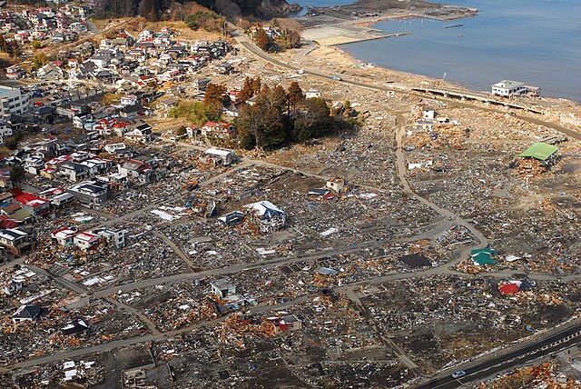
| विवरण |
English: Kirikiri community, Ōtsuchi, Iwate Prefecture, Japan (March 18, 2011) -- An aerial view of damage to Ōtsuchi, Japan, a week after a 9.0 magnitude earthquake and subsequent tsunami devastated the area. (U.S. Navy photo by Mass Communication Specialist 3rd Class Dylan McCord/Released)
|
|||
| दिनांक | Taken on १८ मार्च २०११ | |||
| स्रोत |
|
|||
| लेखक | U.S. Navy photo by Mass Communication Specialist 3rd Class Dylan McCord |

| वस्तु स्थान | | यह और अन्य आसपास की छवियों यहां पर देखें: ओपन स्ट्रीट मैप |
|---|
लाइसेंस
This file is a work of a sailor or employee of the U.S. Navy, taken or made as part of that person's official duties. As a work of the U.S. federal government, it is in the public domain in the United States.
|
 | |
| इस फ़ाइल को कॉपीराइट कानूनों के अंतर्गत सभी संबंधित अधिकारों समेत ज्ञात सीमाओं से मुक्त पहचाना गया है। | ||
चित्र का इतिहास
फ़ाइलका पुराना अवतरण देखने के लिये दिनांक/समय पर क्लिक करें।
| दिनांक/समय | थंबनेल | आकार | सदस्य | प्रतिक्रिया | |
|---|---|---|---|---|---|
| वर्तमान | 02:05, 19 मार्च 2011 | | 3,872 × 2,592 (2.43 MB) | BotMultichillT | == {{int:filedesc}} == {{Information |description={{en|1=SUKUISO, Japan (March 18, 2011) An aerial view of damage to Sukuiso, Japan, a week after a 9.0 magnitude earthquake and subsequent tsunami devastated the area. (U.S. Navy photo by Mass Communication |
चित्र का उपयोग
निम्नलिखित पन्ने इस चित्र से जुडते हैं :
चित्र का वैश्विक उपयोग
इस चित्र का उपयोग इन दूसरे विकियों में किया जाता है:
- de.wikipedia.org पर उपयोग
- en.wikipedia.org पर उपयोग
- fr.wikipedia.org पर उपयोग
- Histoire du Japon
- Hokkaidō
- Sendai
- Préfecture de Chiba
- Préfecture de Fukushima
- Naoto Kan
- Préfecture d'Ibaraki
- Préfecture de Miyagi
- Préfecture d'Iwate
- Région du Tōhoku
- Région du Kantō
- Hakodate
- Higashimatsushima
- Kurihara
- Ishinomaki
- Kesennuma
- Ichihara
- Centrale nucléaire de Fukushima Daiichi
- Centrale nucléaire de Fukushima Daini
- Gouvernement Kan
- Kamaishi
- Séisme de 2011 de la côte Pacifique du Tōhoku
- Accident nucléaire de Fukushima
- Minamisanriku
- Rikuzentakata
- Yukio Edano
- Ōtsuchi
- Chronologie de l'accident nucléaire de Fukushima
- Opération Tomodachi
- Conséquences du séisme de 2011 de la côte Pacifique du Tōhoku sur l'industrie agroalimentaire
- Conséquences du séisme de 2011 de la côte Pacifique du Tōhoku sur l'industrie automobile
- Yoshihiro Murai
- Takuya Tasso
- Yūhei Satō
- Modèle:Palette Séisme de 2011 de la côte Pacifique du Tōhoku
- Conséquences du séisme de 2011 de la côte Pacifique du Tōhoku sur l'industrie du tourisme
- Conséquences de l'accident de Fukushima sur l'industrie nucléaire dans le monde
- Évolution de l'industrie nucléaire en France après l'accident de Fukushima
- Futaba (Fukushima)
- Conséquences de l'accident de Fukushima sur la centrale nucléaire de Fukushima Daiichi
- Conséquences environnementales et sanitaires de l'accident de Fukushima
- Minamisōma
- Ōfunato
- Miyako (Iwate)
- Kitaibaraki
- Pin des miracles
- Conséquences du séisme de 2011 de la côte Pacifique du Tōhoku sur l'industrie du jeu vidéo
इस चित्र के वैश्विक उपयोग की अधिक जानकारी देखें।