
चित्र:Hainan tmo 07feb05 250m.jpg

इस पूर्वावलोकन का आकार: 762 × 600 पिक्सेल। दूसरे रेसोल्यूशन्स: 305 × 240 पिक्सेल | 610 × 480 पिक्सेल | 976 × 768 पिक्सेल | 1,280 × 1,008 पिक्सेल | 1,692 × 1,332 पिक्सेल।
मूल चित्र ((1,692 × 1,332 पिक्सेल, फ़ाइल का आकार: 2.02 MB, MIME प्रकार: image/jpeg))
|
|
यह फ़ाइल विकिमेडिया कॉमन्स से है। वहाँ पर इसका विवरण पृष्ठ निम्नोक्त है। कॉमन्स मुक्त लाइसेंसों के अंतर्गत उपलब्ध मीडिया फ़ाइलों का संग्रह है। आप भी इसमें मदद कर सकते हैं। |
सारांश
| विवरण |
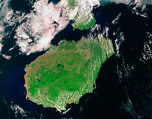
Satelite image of Hainan Island — in the South China Sea.
|
| दिनांक | |
| स्रोत | NASA Visible Earth, http://visibleearth.nasa.gov/view_rec.php?id=19841 |
| लेखक | acquired by the Moderate Resolution Imaging Spectroradiometer (MODIS) on NASA’s Terra satellite. |
लाइसेंस
| This file is in the public domain in the United States because it was solely created by NASA. NASA copyright policy states that "NASA material is not protected by copyright unless noted". (See Template:PD-USGov, NASA copyright policy page or JPL Image Use Policy.) | ||
 |
Warnings:
|
चित्र का इतिहास
फ़ाइलका पुराना अवतरण देखने के लिये दिनांक/समय पर क्लिक करें।
| दिनांक/समय | थंबनेल | आकार | सदस्य | प्रतिक्रिया | |
|---|---|---|---|---|---|
| वर्तमान | 06:42, 25 अगस्त 2007 | | 1,692 × 1,332 (2.02 MB) | ChongDae | {{Information |Description = Satelite image of the Hainan island. |Source = NASA Visible Earth, http://visibleearth.nasa.gov/view_rec.php?id=19841 |Date = 2005-02-07 |Author = acquired by the Moderate Resolution Imaging Spectroradiometer |
चित्र का उपयोग
निम्नलिखित पन्ने इस चित्र से जुडते हैं :
चित्र का वैश्विक उपयोग
इस चित्र का उपयोग इन दूसरे विकियों में किया जाता है:
- af.wikipedia.org पर उपयोग
- bn.wikipedia.org पर उपयोग
- br.wikipedia.org पर उपयोग
- ceb.wikipedia.org पर उपयोग
- el.wikipedia.org पर उपयोग
- eo.wikipedia.org पर उपयोग
- fi.wikipedia.org पर उपयोग
- fr.wikipedia.org पर उपयोग
- fr.wikibooks.org पर उपयोग
- hr.wikipedia.org पर उपयोग
- hy.wikipedia.org पर उपयोग
- ia.wikipedia.org पर उपयोग
- incubator.wikimedia.org पर उपयोग
- is.wikipedia.org पर उपयोग
- it.wikipedia.org पर उपयोग
- ka.wikipedia.org पर उपयोग
- ko.wiktionary.org पर उपयोग
- mn.wikipedia.org पर उपयोग
- mr.wikipedia.org पर उपयोग
- nds.wikipedia.org पर उपयोग
- pa.wikipedia.org पर उपयोग
- ro.wikipedia.org पर उपयोग
- ru.wikipedia.org पर उपयोग
- sk.wikipedia.org पर उपयोग
- uk.wikipedia.org पर उपयोग
- www.wikidata.org पर उपयोग
- zh-yue.wikipedia.org पर उपयोग