
चित्र:CVG airport diagram.svg

पूर्वावलोकन PNG का आकार SVG फ़ाइल: 378 × 548 पिक्सेल दूसरे रेसोल्यूशन्स: 165 × 240 पिक्सेल | 331 × 480 पिक्सेल | 530 × 768 पिक्सेल | 706 × 1,024 पिक्सेल | 1,413 × 2,048 पिक्सेल।
मूल चित्र (SVG फ़ाइल, साधारणतः 378 × 548 पिक्सेल, फ़ाइल का आकार: 1.08 MB)
|
|
यह फ़ाइल विकिमेडिया कॉमन्स से है। वहाँ पर इसका विवरण पृष्ठ निम्नोक्त है। कॉमन्स मुक्त लाइसेंसों के अंतर्गत उपलब्ध मीडिया फ़ाइलों का संग्रह है। आप भी इसमें मदद कर सकते हैं। |
सारांश
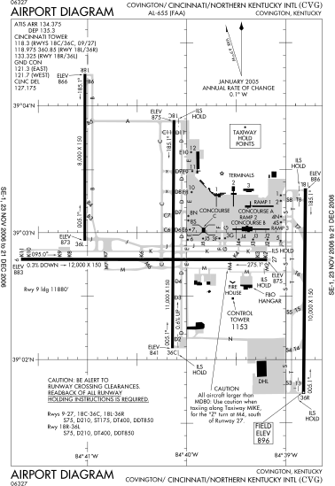
| विवरण | FAA diagram of Cincinnati/Northern Kentucky International Airport. |
| दिनांक | Diagram is dated November 23, 2006–December 31, 2006 |
| स्रोत | Found via NACO site. Converted from this PDF to SVG using this method. |
| लेखक | en:FAA |
| अनुमति (इस चित्र का पुनः उपयोग करना) |
Public domain |
लाइसेंस
This image or file is a work of a Federal Aviation Administration employee, taken or made as part of that person's official duties. As a work of the U.S. federal government, the image is in the public domain in the United States.
|
 |
चित्र का इतिहास
फ़ाइलका पुराना अवतरण देखने के लिये दिनांक/समय पर क्लिक करें।
| दिनांक/समय | थंबनेल | आकार | सदस्य | प्रतिक्रिया | |
|---|---|---|---|---|---|
| वर्तमान | 15:27, 5 जनवरी 2007 | | 378 × 548 (1.08 MB) | Grendelkhan | {{Information |Description=FAA diagram of Cincinnati/Northern Kentucky International Airport. |Source=Found via [http://gc.kls2.com/airport/CVG Great Circle Mapper]. Converted from [http://www.naco.faa.gov/d-tpp/0612/00655AD.PDF this PDF] to SVG using [[: |
चित्र का उपयोग
इस चित्र से कोई पन्ने नहीं जुड़ते
चित्र का वैश्विक उपयोग
इस चित्र का उपयोग इन दूसरे विकियों में किया जाता है:
- de.wikipedia.org पर उपयोग
- fr.wikipedia.org पर उपयोग
- it.wikipedia.org पर उपयोग
- ja.wikipedia.org पर उपयोग
- pl.wikipedia.org पर उपयोग
- pt.wikipedia.org पर उपयोग
- ru.wikipedia.org पर उपयोग
- vi.wikipedia.org पर उपयोग
- zh.wikipedia.org पर उपयोग