
चित्र:World trade map.PNG

इस पूर्वावलोकन का आकार: 800 × 370 पिक्सेल। दूसरे रेसोल्यूशन्स: 320 × 148 पिक्सेल | 640 × 296 पिक्सेल | 1,357 × 628 पिक्सेल।
मूल चित्र ((1,357 × 628 पिक्सेल, फ़ाइल का आकार: 41 KB, MIME प्रकार: image/png))
|
|
यह फ़ाइल विकिमेडिया कॉमन्स से है। वहाँ पर इसका विवरण पृष्ठ निम्नोक्त है। कॉमन्स मुक्त लाइसेंसों के अंतर्गत उपलब्ध मीडिया फ़ाइलों का संग्रह है। आप भी इसमें मदद कर सकते हैं। |
सारांश

|
This economic map image could be re-created using vector graphics as an SVG file. This has several advantages; see Commons:Media for cleanup for more information. If an SVG form of this image is available, please upload it and afterwards replace this template with
{{vector version available|new image name}}.
It is recommended to name the SVG file “World trade map.svg”—then the template Vector version available (or Vva) does not need the new image name parameter. |
| विवरण |
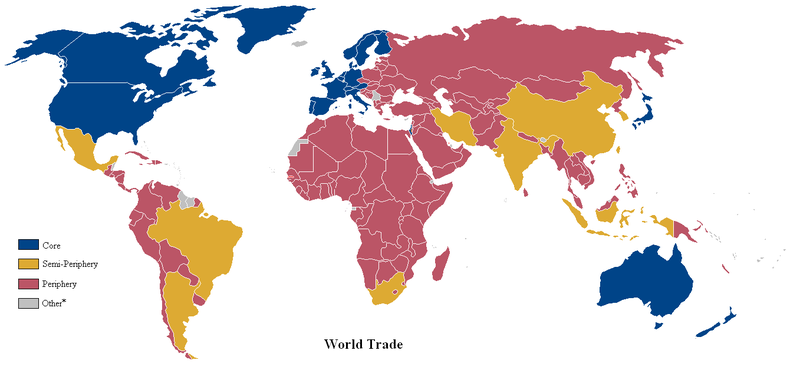
English: A world map of countries by trading status, late 20th century, using the world system differentiation into core countries, semi-periphery countries and periphery countries. Based on a list in Christopher Chase-Dunn, Yukio Kawano and Benjamin Brewer, Trade Globalization since 1795, American Sociological Review, 2000 February, Vol. 65 article, Appendix with the country list *Some countries with a population of less than one million were excluded from the analysis. |
| दिनांक | (UTC) |
| स्रोत | Based on File:Anglosphere_map.png. |
| लेखक | Lou Coban |
लाइसेंस
| इस कार्य को इसके लेखक, User:Naboc1 द्वारा सार्वजनिक डोमेन में प्रकाशित किया गया है। यह पूरे विश्व में लागू होता है। कुछ देशों में यह कानूनी तौर पर नहीं हो सकता है; ऐसा हो तो: User:Naboc1 सभी को इस कार्य का इस्तेमाल किसी भी उद्देश्य से, बिना किसी बाधाओं के इन शर्तों के कानून द्वारा अनिवार्य किए तक करने की अनुमति देता/देती हैं।
|
मूल अपलोड लॉग
Transferred from en.wikipedia to Commons by Piotrus using CommonsHelper.
The original description page was here. All following user names refer to en.wikipedia.
- 2010-08-09 23:12 Altes 1357×628× (49371 bytes) fixed Brazil & Argentine
- 2010-06-11 01:32 Naboc1 1357×628× (49325 bytes) Included a new "other" category to denote countries with a population less than one million.
- 2010-06-10 18:09 Naboc1 1357×628× (48916 bytes) Updated Greenland as a core country since it is a part of Denmark
- 2010-06-10 05:40 Naboc1 1357×628× (48911 bytes) Updated some coutries that were incorrectly indicated as the wrong status.
- 2010-06-07 06:23 Naboc1 1357×628× (48895 bytes) {{Information |Description = A World map of countries by trading status |Source = |Date = ~~~~~ |Author = Lou Coban |Permission = |other_versions = }}
चित्र का इतिहास
फ़ाइलका पुराना अवतरण देखने के लिये दिनांक/समय पर क्लिक करें।
| दिनांक/समय | थंबनेल | आकार | सदस्य | प्रतिक्रिया | |
|---|---|---|---|---|---|
| वर्तमान | 00:20, 6 जून 2022 | | 1,357 × 628 (41 KB) | Benjamintf1 | More colorblind friendly, as requested in talk page |
| 18:18, 18 नवम्बर 2010 |  | 1,357 × 628 (48 KB) | File Upload Bot (Magnus Manske) | {{BotMoveToCommons|en.wikipedia|year={{subst:CURRENTYEAR}}|month={{subst:CURRENTMONTHNAME}}|day={{subst:CURRENTDAY}}}} {{Information |Description={{en|A world map of countries by trading status, late 20th century, using the en:world system differen |
चित्र का उपयोग
निम्नलिखित पन्ने इस चित्र से जुडते हैं :
चित्र का वैश्विक उपयोग
इस चित्र का उपयोग इन दूसरे विकियों में किया जाता है:
- ca.wikipedia.org पर उपयोग
- cs.wikipedia.org पर उपयोग
- de.wikipedia.org पर उपयोग
- en.wikipedia.org पर उपयोग
- en.wikiversity.org पर उपयोग
- es.wikipedia.org पर उपयोग
- fa.wikipedia.org पर उपयोग
- gl.wikipedia.org पर उपयोग
- hu.wikipedia.org पर उपयोग
- hy.wikipedia.org पर उपयोग
- id.wikipedia.org पर उपयोग
- ms.wikipedia.org पर उपयोग
- pl.wikipedia.org पर उपयोग
- pt.wikipedia.org पर उपयोग
- uk.wikipedia.org पर उपयोग
- uz.wikipedia.org पर उपयोग
- zh.wikipedia.org पर उपयोग