
चित्र:Shakemap Ecuador April 2016.jpg
इस पूर्वावलोकन का आकार: 456 × 599 पिक्सेल। दूसरे रेसोल्यूशन्स: 183 × 240 पिक्सेल | 365 × 480 पिक्सेल | 762 × 1,001 पिक्सेल।
मूल चित्र ((762 × 1,001 पिक्सेल, फ़ाइल का आकार: 288 KB, MIME प्रकार: image/jpeg))
|
|
यह फ़ाइल विकिमेडिया कॉमन्स से है। वहाँ पर इसका विवरण पृष्ठ निम्नोक्त है। कॉमन्स मुक्त लाइसेंसों के अंतर्गत उपलब्ध मीडिया फ़ाइलों का संग्रह है। आप भी इसमें मदद कर सकते हैं। |
सारांश
| विवरण |
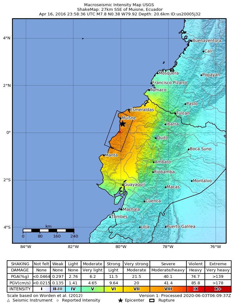
English: Shakemap for the 2016 Ecuador earthquake
Español: Mapa de intensidades sísmicas para el terremoto de Ecuador de 2016
Magyar: A 2016-os ecuadori földrengés rengéseinek térképe |
| दिनांक | |
| स्रोत | https://earthquake.usgs.gov/earthquakes/eventpage/us20005j32#shakemap |
| लेखक | United States Geological Survey |
लाइसेंस
This image is in the public domain in the United States because it only contains materials that originally came from the United States Geological Survey, an agency of the United States Department of the Interior. For more information, see the official USGS copyright policy.
|
चित्र का इतिहास
फ़ाइलका पुराना अवतरण देखने के लिये दिनांक/समय पर क्लिक करें।
| दिनांक/समय | थंबनेल | आकार | सदस्य | प्रतिक्रिया | |
|---|---|---|---|---|---|
| वर्तमान | 19:36, 25 जून 2023 | | 762 × 1,001 (288 KB) | 4kolechia | added newer version |
| 19:23, 17 अप्रैल 2016 |  | 2,125 × 2,480 (1.76 MB) | Kiwi128 | higher resolution version rendered from postscript file | |
| 16:07, 17 अप्रैल 2016 |  | 612 × 717 (102 KB) | Skycycle | Update via USGS, new intensity and depth | |
| 00:39, 17 अप्रैल 2016 |  | 612 × 717 (100 KB) | GroundControl01 | User created page with UploadWizard |
चित्र का उपयोग
निम्नलिखित पन्ने इस चित्र से जुडते हैं :
चित्र का वैश्विक उपयोग
इस चित्र का उपयोग इन दूसरे विकियों में किया जाता है:
- ar.wikipedia.org पर उपयोग
- bg.wikipedia.org पर उपयोग
- de.wikipedia.org पर उपयोग
- en.wikipedia.org पर उपयोग
- es.wikipedia.org पर उपयोग
- es.wikinews.org पर उपयोग
- fi.wikipedia.org पर उपयोग
- fr.wikipedia.org पर उपयोग
- hu.wikipedia.org पर उपयोग
- hy.wikipedia.org पर उपयोग
- id.wikipedia.org पर उपयोग
- it.wikipedia.org पर उपयोग
- ja.wikipedia.org पर उपयोग
- ko.wikipedia.org पर उपयोग
- ky.wikipedia.org पर उपयोग
- la.wikipedia.org पर उपयोग
- ms.wikipedia.org पर उपयोग
- nl.wikipedia.org पर उपयोग
- no.wikipedia.org पर उपयोग
- ro.wikipedia.org पर उपयोग
- ru.wikipedia.org पर उपयोग
- ru.wikinews.org पर उपयोग
- uk.wikipedia.org पर उपयोग
- vi.wikipedia.org पर उपयोग