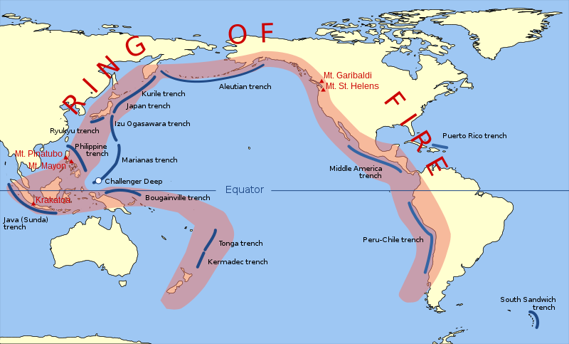
चित्र:Pacific Ring of Fire.svg

पूर्वावलोकन PNG का आकार SVG फ़ाइल: 800 × 483 पिक्सेल दूसरे रेसोल्यूशन्स: 320 × 193 पिक्सेल | 640 × 387 पिक्सेल | 1,024 × 619 पिक्सेल | 1,280 × 773 पिक्सेल | 2,560 × 1,546 पिक्सेल | 942 × 569 पिक्सेल।
मूल चित्र (SVG फ़ाइल, साधारणतः 942 × 569 पिक्सेल, फ़ाइल का आकार: 294 KB)
चित्र का इतिहास
फ़ाइलका पुराना अवतरण देखने के लिये दिनांक/समय पर क्लिक करें।
| दिनांक/समय | थंबनेल | आकार | सदस्य | प्रतिक्रिया | |
|---|---|---|---|---|---|
| वर्तमान | 11:30, 20 मार्च 2015 |  | 942 × 569 (294 KB) | Szczureq | Ryuku → Ryukyu |
| 13:19, 15 मार्च 2011 |  | 942 × 569 (294 KB) | AnonMoos | trimming transparent margins | |
| 19:25, 3 मार्च 2009 |  | 796 × 472 (314 KB) | Kmusser | Fix volanco symbols | |
| 19:04, 3 मार्च 2009 |  | 796 × 472 (317 KB) | Kmusser | repositioned volcanoes | |
| 23:24, 13 फ़रवरी 2009 |  | 781 × 472 (145 KB) | Inductiveload | added volcanos | |
| 17:18, 11 फ़रवरी 2009 |  | 781 × 472 (138 KB) | Inductiveload | added labels, aluetian isles and south sandwich islands, as these are associated with the nearby trenches. also put everything into layers. | |
| 23:58, 10 फ़रवरी 2009 |  | 781 × 472 (111 KB) | Gringer | Resized image 3x so that nominal size is reasonable in default Wikipedia image display. | |
| 23:52, 10 फ़रवरी 2009 |  | 260 × 157 (112 KB) | Gringer | {{Information |Description={{en|1=SVG version of File:Pacific_Ring_of_Fire.png, recreated by me using WDB vector data using code mentioned in File:Worldmap_wdb_combined.svg.}} |Source=vector data from [http://www.evl.uic.edu/pape/data/WDB/] |Aut |
चित्र का उपयोग
निम्नलिखित पन्ने इस चित्र से जुडते हैं :
चित्र का वैश्विक उपयोग
इस चित्र का उपयोग इन दूसरे विकियों में किया जाता है:
- af.wikipedia.org पर उपयोग
- ar.wikipedia.org पर उपयोग
- ast.wikipedia.org पर उपयोग
- ban.wikipedia.org पर उपयोग
- bcl.wikipedia.org पर उपयोग
- bg.wikipedia.org पर उपयोग
- bn.wikipedia.org पर उपयोग
- bs.wikipedia.org पर उपयोग
- da.wikipedia.org पर उपयोग
- el.wikipedia.org पर उपयोग
- en.wikipedia.org पर उपयोग
- en.wikibooks.org पर उपयोग
- en.wikivoyage.org पर उपयोग
- en.wiktionary.org पर उपयोग
- es.wikipedia.org पर उपयोग
- fa.wikipedia.org पर उपयोग
- fi.wikipedia.org पर उपयोग
- he.wikipedia.org पर उपयोग
- hu.wikipedia.org पर उपयोग
- ilo.wikipedia.org पर उपयोग
- incubator.wikimedia.org पर उपयोग
- is.wikipedia.org पर उपयोग
- is.wikibooks.org पर उपयोग
- it.wikibooks.org पर उपयोग
- ja.wikipedia.org पर उपयोग
- ja.wikibooks.org पर उपयोग
- jv.wikipedia.org पर उपयोग
- ka.wikipedia.org पर उपयोग
- kk.wikipedia.org पर उपयोग
- la.wikipedia.org पर उपयोग
- lv.wikipedia.org पर उपयोग
इस चित्र के वैश्विक उपयोग की अधिक जानकारी देखें।


