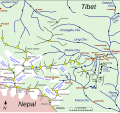
चित्र:Map of Kharta region, east of Mount Everest.svg

पृष्ठ की सामग्री दूसरी भाषाओं में उपलब्ध नहीं है।
मुक्त ज्ञानकोश विकिपीडिया से

मूल चित्र(SVG फ़ाइल, साधारणतः 1,279 × 1,194 पिक्सेल, फ़ाइल का आकार: 464 KB)

सारांश

विवरण
English: Sketch map of w:Kharta and Kama velleys and environs, east of Mount Everest

The information on the map comes from File:Preliminary map of Mount Everest Expedition, 1921. Map I.jpg and
Reynolds, Kev (2011). "Trek 9, Kharta to the Kangshung Face". Everest : a trekker's guide : 9 treks in the Everest region, pp 234-235. Milnthorpe: Cicerone. ISBN 9781852846800. Retrieved 24 August 2014.
Howard-Bury, Charles; Mallory, George Leigh (1991). Keaney, Marian, ed. Everest Reconnaissance : The First Expedition of 1921, map "Approaches to Everest". London: Hodder & Stoughton. ISBN 0340556021.

plus information picked up in reading and web browsing. Villages and camps (red dots) are not distinguished and have not been included systematically. The Howard Bury book of the w:1921 British Mount Everest reconnaissance expedition mentions a number of villages in the lower Kharta Chu but does not name many of them. Glaciers are shown (schematically) roughly as they are at present. In 1921 they were larger – the Kangdushong Glacier went right across the Kama valley to the far side so blocking the progress of the Kangshung Glacier. Many place names have various romanisations and I have simply chosen one that seems appropriate. The red pecked line showing the routes taken in 1921 include routes taken by only some members of the expedition. However, routes taken by the surveyors have not been recorded. The green pecked line for present-day trekking is simply an example typical of what is being offered. Going to Samchung La (and on to Chog La) and back seems a shortish trek that some take.
दिनांक
स्रोत अपना कार्य
लेखक Thincat

लाइसेंस

मैं, इस कार्य का/की कॉपीराइट धारक, इसे निम्न लाइसेंस के अंतर्गत प्रकाशित करता/करती हूँ:
w:hi:क्रिएटिव कॉमन्स
श्रेय समानसांझा
इस फ़ाइल को क्रिएटिव कॉमन्स श्रेय-समानसांझा 4.0 अंतर्राष्ट्रीय लाइसेंस के अंतर्गत लाइसेंस किया गया है।
आप खुलकर:
  • बाँट सकते हैं – रचना की प्रतिलिपि बना सकते हैं, बाँँट सकते हैं और संचारित कर सकते हैं
  • रीमिक्स कर सकते हैं – कार्य को अनुकूलित कर सकते हैं
निम्नलिखित शर्तों के अंतर्गत:
  • श्रेय – यह अनिवार्य है कि आप यथोचित श्रेय प्रदान करें, लाइसेंस की कड़ी प्रदान करें, और अगर कोई बदलाव हुए हों तो उन्हें इंगित करें। आप ऐसा किसी भी उचित तरीके से कर सकते हैं, लेकिन किसी भी तरह उससे यह नहीं संकेत नहीं किया जाना चाहिए कि लाइसेंसधारी द्वारा आपको अथवा आपके इस प्रयोग का समर्थन किया जा रहा हो।
  • समानसांझा – अगर आप इस रचना में कोई बदलाव करते हैं या इसपर आधारित कुछ रचित करते हैं तो आप अपने योगदान को सिर्फ इसी या इसके सामान किसी लाइसेंस के अंतर्गत बाँट सकते हैं।

Captions

Add a one-line explanation of what this file represents

Items portrayed in this file

चित्रण

source of file अंग्रेज़ी

original creation by uploader अंग्रेज़ी

चित्र का इतिहास

फ़ाइलका पुराना अवतरण देखने के लिये दिनांक/समय पर क्लिक करें।

(सबसे नया | सबसे पुराना) देखें (नए 10) () (10 | 20 | 50 | 100 | 250 | 500)
दिनांक/समयथंबनेलआकारसदस्यप्रतिक्रिया
वर्तमान19:31, 26 अगस्त 201419:31, 26 अगस्त 2014 के संस्करण का थंबनेल संस्करण1,279 × 1,194 (464 KB)Thincat1921 Everest reconnaissance routes and example trekking route shown
23:11, 25 अगस्त 201423:11, 25 अगस्त 2014 के संस्करण का थंबनेल संस्करण1,279 × 1,194 (451 KB)ThincatMinor additions and corrections
16:19, 25 अगस्त 201416:19, 25 अगस्त 2014 के संस्करण का थंबनेल संस्करण1,279 × 1,194 (422 KB)ThincatLumeh, Kangchungtse (Makalu II), ...
10:18, 25 अगस्त 201410:18, 25 अगस्त 2014 के संस्करण का थंबनेल संस्करण1,279 × 1,194 (420 KB)ThincatExtended north
23:51, 24 अगस्त 201423:51, 24 अगस्त 2014 के संस्करण का थंबनेल संस्करण1,280 × 718 (105 KB)ThincatLes violent colours
23:30, 24 अगस्त 201423:30, 24 अगस्त 2014 के संस्करण का थंबनेल संस्करण1,280 × 718 (105 KB)ThincatAdd Rongbuk Glacier, etc.
22:45, 24 अगस्त 201422:45, 24 अगस्त 2014 के संस्करण का थंबनेल संस्करण1,280 × 718 (102 KB)ThincatMore tidying
20:08, 24 अगस्त 201420:08, 24 अगस्त 2014 के संस्करण का थंबनेल संस्करण1,213 × 713 (93 KB)ThincatSlight tidy
19:30, 24 अगस्त 201419:30, 24 अगस्त 2014 के संस्करण का थंबनेल संस्करण1,213 × 713 (89 KB)ThincatCrop
19:25, 24 अगस्त 201419:25, 24 अगस्त 2014 के संस्करण का थंबनेल संस्करण1,231 × 844 (87 KB)ThincatVarious. Continuing Kharta Chu, etc
(सबसे नया | सबसे पुराना) देखें (नए 10) () (10 | 20 | 50 | 100 | 250 | 500)

निम्नलिखित पन्ने इस चित्र से जुडते हैं :

चित्र का वैश्विक उपयोग

इस चित्र का उपयोग इन दूसरे विकियों में किया जाता है:

मेटाडेटा