
चित्र:Hamoun Oasis salt flatlands 2001 satellite.jpg

इस पूर्वावलोकन का आकार: 439 × 600 पिक्सेल। दूसरे रेसोल्यूशन्स: 176 × 240 पिक्सेल | 351 × 480 पिक्सेल | 711 × 971 पिक्सेल।
मूल चित्र ((711 × 971 पिक्सेल, फ़ाइल का आकार: 120 KB, MIME प्रकार: image/jpeg))
|
|
यह फ़ाइल विकिमेडिया कॉमन्स से है। वहाँ पर इसका विवरण पृष्ठ निम्नोक्त है। कॉमन्स मुक्त लाइसेंसों के अंतर्गत उपलब्ध मीडिया फ़ाइलों का संग्रह है। आप भी इसमें मदद कर सकते हैं। |
सारांश
| विवरण |
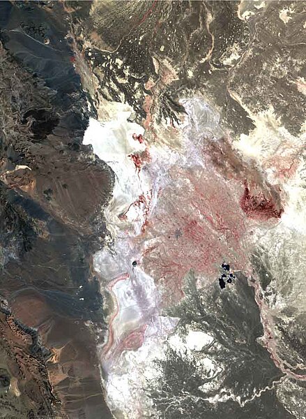
English: In 2001, Hamoun wetlands vanished as Central and South Asia were hitby the largest persistent drought anywhere in the world in period 1999-2001.
The only sign of water in this scorched landscape of extensive salt flats (white) is the Chah Nimeh reservoir in the center right of the image, which is now only used for drinking water. Degraded reed stands in muddy soil are visible as dark red in the southern end of Hamoun-i Puzak. Landsat 7 ETM+ false colour composite created from a combination of the near-infrared, red and green bands (bands 4, 3, and 2) useful for monitoring water and vegetation. |
| दिनांक | |
| स्रोत | http://www.grid.unep.ch/activities/global_change/sistan.php |
| लेखक | United Nations Environment Programme |
लाइसेंस
| This file is in the public domain in the United States because it was solely created by NASA. NASA copyright policy states that "NASA material is not protected by copyright unless noted". (See Template:PD-USGov, NASA copyright policy page or JPL Image Use Policy.) | ||
 |
Warnings:
|
चित्र का इतिहास
फ़ाइलका पुराना अवतरण देखने के लिये दिनांक/समय पर क्लिक करें।
| दिनांक/समय | थंबनेल | आकार | सदस्य | प्रतिक्रिया | |
|---|---|---|---|---|---|
| वर्तमान | 04:37, 25 सितंबर 2010 | | 711 × 971 (120 KB) | Aikenware | {{Information |Description={{en|1=In 2001, Hamoun wetlands vanished as Central and South Asia were hitby the largest persistent drought anywhere in the world in period 1999-2001. The only sign of water in this scorched landscape of extensive salt flats ( |
चित्र का उपयोग
निम्नलिखित पन्ने इस चित्र से जुडते हैं :
चित्र का वैश्विक उपयोग
इस चित्र का उपयोग इन दूसरे विकियों में किया जाता है:
- be.wikipedia.org पर उपयोग
- eo.wikipedia.org पर उपयोग
- es.wikipedia.org पर उपयोग
- fr.wikipedia.org पर उपयोग
- lt.wikipedia.org पर उपयोग
- ru.wikipedia.org पर उपयोग
- sv.wikipedia.org पर उपयोग
- ta.wikipedia.org पर उपयोग
- uk.wikipedia.org पर उपयोग