
चित्र:Pakistan Railways Network Map.png
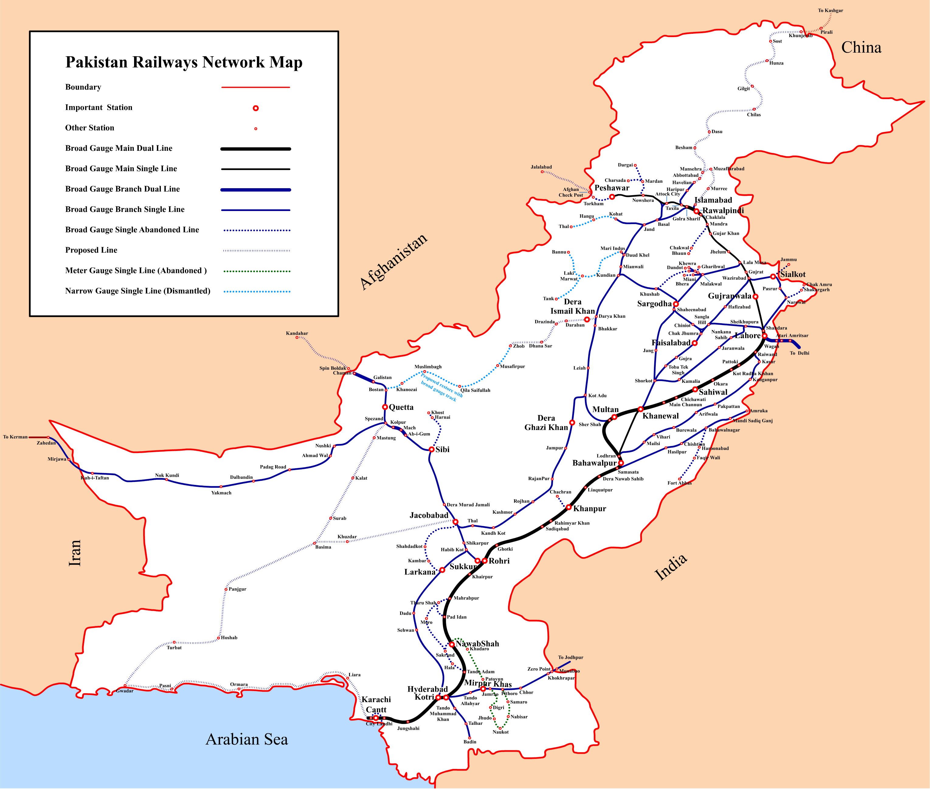
इस पूर्वावलोकन का आकार: 707 × 600 पिक्सेल। दूसरे रेसोल्यूशन्स: 283 × 240 पिक्सेल | 566 × 480 पिक्सेल | 905 × 768 पिक्सेल | 1,207 × 1,024 पिक्सेल | 2,414 × 2,048 पिक्सेल | 3,059 × 2,595 पिक्सेल।
मूल चित्र ((3,059 × 2,595 पिक्सेल, फ़ाइल का आकार: 648 KB, MIME प्रकार: image/png))
|
|
यह फ़ाइल विकिमेडिया कॉमन्स से है। वहाँ पर इसका विवरण पृष्ठ निम्नोक्त है। कॉमन्स मुक्त लाइसेंसों के अंतर्गत उपलब्ध मीडिया फ़ाइलों का संग्रह है। आप भी इसमें मदद कर सकते हैं। |
सारांश
| Description |
English: Pakistan Railways Network Map |
|||||||||
| दिनांक | ||||||||||
| स्रोत | अपना कार्य | |||||||||
| रचियता | ||||||||||
| Geotemporal data | ||||||||||
| Bounding box |
|
|||||||||
| Georeferencing | ||||||||||
लाइसेंस
मैं, इस कार्य का/की कॉपीराइट धारक, इसे निम्न लाइसेंस के अंतर्गत प्रकाशित करता/करती हूँ:
इस फ़ाइल को क्रिएटिव कॉमन्स श्रेय-समानसांझा 3.0 अनरिपोर्टेड लाइसेंस के अंतर्गत लाइसेंस किया गया है।
- आप खुलकर:
- बाँट सकते हैं – रचना की प्रतिलिपि बना सकते हैं, बाँँट सकते हैं और संचारित कर सकते हैं
- रीमिक्स कर सकते हैं – कार्य को अनुकूलित कर सकते हैं
- निम्नलिखित शर्तों के अंतर्गत:
- श्रेय – यह अनिवार्य है कि आप यथोचित श्रेय प्रदान करें, लाइसेंस की कड़ी प्रदान करें, और अगर कोई बदलाव हुए हों तो उन्हें इंगित करें। आप ऐसा किसी भी उचित तरीके से कर सकते हैं, लेकिन किसी भी तरह उससे यह नहीं संकेत नहीं किया जाना चाहिए कि लाइसेंसधारी द्वारा आपको अथवा आपके इस प्रयोग का समर्थन किया जा रहा हो।
- समानसांझा – अगर आप इस रचना में कोई बदलाव करते हैं या इसपर आधारित कुछ रचित करते हैं तो आप अपने योगदान को सिर्फ इसी या इसके सामान किसी लाइसेंस के अंतर्गत बाँट सकते हैं।
चित्र का इतिहास
फ़ाइलका पुराना अवतरण देखने के लिये दिनांक/समय पर क्लिक करें।
| दिनांक/समय | थंबनेल | आकार | सदस्य | प्रतिक्रिया | |
|---|---|---|---|---|---|
| वर्तमान | 17:49, 3 सितंबर 2016 | | 3,059 × 2,595 (648 KB) | Adnanleon | Updated Karachi-Lahore dual railway track, Added Karachi-Gwadar, Islamabad-Muzaffarabad and Basima-Jacobabad proposed railway lines. |
| 11:44, 27 जनवरी 2014 |  | 3,032 × 2,572 (591 KB) | RaviC | + Jammu link | |
| 20:54, 31 जुलाई 2013 |  | 3,032 × 2,572 (628 KB) | Adnanleon | Fill white color in center | |
| 20:27, 31 जुलाई 2013 |  | 3,032 × 2,572 (560 KB) | Adnanleon | Correction in Sahiwal-Raiwind section and Pak-China proposed railway line | |
| 08:27, 1 मार्च 2012 |  | 3,042 × 2,557 (517 KB) | Nomi887 | Added colour (reason: to make map prominent) | |
| 22:21, 28 फ़रवरी 2012 |  | 3,042 × 2,557 (585 KB) | Sven Manguard | Removing time and author from image. This is *NOT* the version sent by OTRS, that one is immediately below. | |
| 22:12, 28 फ़रवरी 2012 |  | 3,042 × 2,557 (595 KB) | Sven Manguard | Update sent via OTRS photosubmissions | |
| 18:55, 22 नवम्बर 2011 |  | 3,010 × 2,540 (466 KB) | Adnanleon |
चित्र का उपयोग
निम्नलिखित पन्ने इस चित्र से जुडते हैं :
चित्र का वैश्विक उपयोग
इस चित्र का उपयोग इन दूसरे विकियों में किया जाता है:
- bn.wikipedia.org पर उपयोग
- de.wikipedia.org पर उपयोग
- de.wikivoyage.org पर उपयोग
- en.wikipedia.org पर उपयोग
- en.wikivoyage.org पर उपयोग
- eo.wikipedia.org पर उपयोग
- fr.wikipedia.org पर उपयोग
- hu.wikipedia.org पर उपयोग
- it.wikivoyage.org पर उपयोग
- ja.wikipedia.org पर उपयोग
- mr.wikipedia.org पर उपयोग
- pl.wikipedia.org पर उपयोग
- pnb.wikipedia.org पर उपयोग
इस चित्र के वैश्विक उपयोग की अधिक जानकारी देखें।