
चित्र:Monthly zonal mean precipitation.png

इस पूर्वावलोकन का आकार: 680 × 599 पिक्सेल। दूसरे रेसोल्यूशन्स: 272 × 240 पिक्सेल | 545 × 480 पिक्सेल | 871 × 768 पिक्सेल | 1,162 × 1,024 पिक्सेल | 1,892 × 1,668 पिक्सेल।
मूल चित्र ((1,892 × 1,668 पिक्सेल, फ़ाइल का आकार: 48 KB, MIME प्रकार: image/png))
|
|
यह फ़ाइल विकिमेडिया कॉमन्स से है। वहाँ पर इसका विवरण पृष्ठ निम्नोक्त है। कॉमन्स मुक्त लाइसेंसों के अंतर्गत उपलब्ध मीडिया फ़ाइलों का संग्रह है। आप भी इसमें मदद कर सकते हैं। |
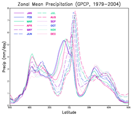
| विवरण | A graph showing the montly mean zonal precipitation as a function of latitude. |
| दिनांक | (UTC) |
| स्रोत | |
| लेखक |
|
| This is a retouched picture, which means that it has been digitally altered from its original version. Modifications: convert to png; crop. The original can be viewed here: Monthly zonal mean precipitation.gif:
|
| This file is in the public domain in the United States because it was solely created by NASA. NASA copyright policy states that "NASA material is not protected by copyright unless noted". (See Template:PD-USGov, NASA copyright policy page or JPL Image Use Policy.) | ||
 |
Warnings:
|
मूल अपलोड लॉग
This image is a derivative work of the following images:
- File:Monthly_zonal_mean_precipitation.gif licensed with PD-USGov-NASA
- 2010-11-18T15:48:46Z Atmoz 2200x1700 (266511 Bytes) {{Information |Description=A graph showing the montly mean [[w:zonal|zonal]] [[w:precipitation|precipitation]] as a function of latitude. |Source=[http://gmao.gsfc.nasa.gov/research/merra/sci_archive/GPCP/plot_GP_zonal_all.gi
Uploaded with derivativeFX
चित्र का इतिहास
फ़ाइलका पुराना अवतरण देखने के लिये दिनांक/समय पर क्लिक करें।
| दिनांक/समय | थंबनेल | आकार | सदस्य | प्रतिक्रिया | |
|---|---|---|---|---|---|
| वर्तमान | 15:56, 18 नवम्बर 2010 | | 1,892 × 1,668 (48 KB) | Atmoz | {{Information |Description=A graph showing the montly mean zonal precipitation as a function of latitude. |Source=*File:Monthly_zonal_mean_precipitation.gif |Date=2010-11-18 15:55 (UTC) |Author=*[[:File:Monthly_zonal_ |
चित्र का उपयोग
निम्नलिखित पन्ने इस चित्र से जुडते हैं :
चित्र का वैश्विक उपयोग
इस चित्र का उपयोग इन दूसरे विकियों में किया जाता है:
- ar.wikipedia.org पर उपयोग
- bn.wikipedia.org पर उपयोग
- ca.wikipedia.org पर उपयोग
- en.wikipedia.org पर उपयोग
- en.wikiversity.org पर उपयोग
- gv.wikipedia.org पर उपयोग
- ha.wikipedia.org पर उपयोग
- id.wikipedia.org पर उपयोग
- or.wikipedia.org पर उपयोग