
चित्र:Southeast asia.svg

पूर्वावलोकन PNG का आकार SVG फ़ाइल: 506 × 598 पिक्सेल दूसरे रेसोल्यूशन्स: 203 × 240 पिक्सेल | 406 × 480 पिक्सेल | 650 × 768 पिक्सेल | 866 × 1,024 पिक्सेल | 1,733 × 2,048 पिक्सेल।
मूल चित्र (SVG फ़ाइल, साधारणतः 506 × 598 पिक्सेल, फ़ाइल का आकार: 729 KB)
|
|
यह फ़ाइल विकिमेडिया कॉमन्स से है। वहाँ पर इसका विवरण पृष्ठ निम्नोक्त है। कॉमन्स मुक्त लाइसेंसों के अंतर्गत उपलब्ध मीडिया फ़ाइलों का संग्रह है। आप भी इसमें मदद कर सकते हैं। |
सारांश
| विवरण |
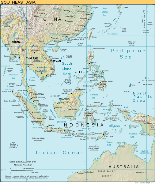
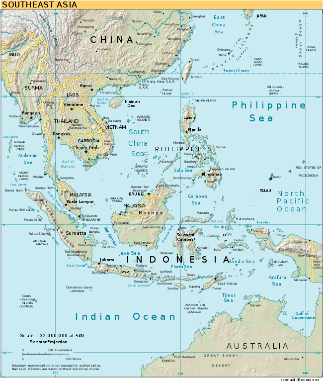
English: Southeast Asia |
| स्रोत | CIA World Factbook converted in SVG |
| लेखक | |
| दूसरे संस्करण |
[]
|
| SVG genesis |


लाइसेंस
This image is in the public domain because it contains materials that originally came from the United States Central Intelligence Agency's World Factbook.
|
 |
चित्र का इतिहास
फ़ाइलका पुराना अवतरण देखने के लिये दिनांक/समय पर क्लिक करें।
| दिनांक/समय | थंबनेल | आकार | सदस्य | प्रतिक्रिया | |
|---|---|---|---|---|---|
| वर्तमान | 17:02, 17 मई 2018 | | 506 × 598 (729 KB) | Glrx | guess image/jpeg |
| 18:04, 24 जनवरी 2006 |  | 506 × 598 (729 KB) | Moyogo | stripping useless stuff | |
| 20:21, 23 जनवरी 2006 |  | 506 × 598 (1.04 MB) | Sanao | Southeast Asia<br /> Origin : CIA World Factbook converted in SVG Category:SVG maps Category:Southeast Asia |
चित्र का उपयोग
इस चित्र से कोई पन्ने नहीं जुड़ते
चित्र का वैश्विक उपयोग
इस चित्र का उपयोग इन दूसरे विकियों में किया जाता है:
- ar.wikipedia.org पर उपयोग
- da.wikipedia.org पर उपयोग
- en.wikipedia.org पर उपयोग
- Southeast Asia
- Talk:Jemaah Islamiyah
- Talk:Slow loris
- Talk:Selenocosmia
- Talk:Neriene
- Talk:Amyciaea
- Talk:Achaearanea
- Talk:Episinus
- Talk:Argyrodes
- Talk:Meta (spider)
- Talk:Asemonea
- Talk:Augustaea
- Talk:Bocus
- Talk:Burmattus
- Talk:Chrysilla
- Talk:Chinattus
- Talk:Chalcotropis
- Talk:Chalcoscirtus
- Talk:Ceglusa
- Talk:Carrhotus
- Talk:Canama
- Talk:Copocrossa
- Talk:Colyttus
- Talk:Cocalus (spider)
- Talk:Cocalodes
- Talk:Diplocanthopoda
- Talk:Euophrys
- Talk:Ergane (spider)
- Talk:Epocilla
- Talk:Epidelaxia
- Talk:Gelotia
- Talk:Marengo (spider)
- Talk:Mantisatta
- Talk:Magyarus
- Talk:Mintonia
- Talk:Menemerus
- Talk:Mendoza (spider)
- Talk:Neobrettus
- Talk:Nannenus
- Talk:Orthrus (spider)
- Talk:Orsima
- Talk:Onomastus
- Talk:Nungia
- Talk:Panysinus
- Talk:Pancorius
- Talk:Philates
- Talk:Phintella
- Talk:Phlegra (spider)
इस चित्र के वैश्विक उपयोग की अधिक जानकारी देखें।