
चित्र:India-Pakistan Borderlands at Night.JPG
इस पूर्वावलोकन का आकार: 800 × 532 पिक्सेल। दूसरे रेसोल्यूशन्स: 320 × 213 पिक्सेल | 640 × 426 पिक्सेल | 1,024 × 681 पिक्सेल | 1,280 × 852 पिक्सेल | 2,560 × 1,703 पिक्सेल | 4,256 × 2,832 पिक्सेल।
मूल चित्र ((4,256 × 2,832 पिक्सेल, फ़ाइल का आकार: 3.11 MB, MIME प्रकार: image/jpeg))
|
|
यह फ़ाइल विकिमेडिया कॉमन्स से है। वहाँ पर इसका विवरण पृष्ठ निम्नोक्त है। कॉमन्स मुक्त लाइसेंसों के अंतर्गत उपलब्ध मीडिया फ़ाइलों का संग्रह है। आप भी इसमें मदद कर सकते हैं। |
सारांश
| विवरण |
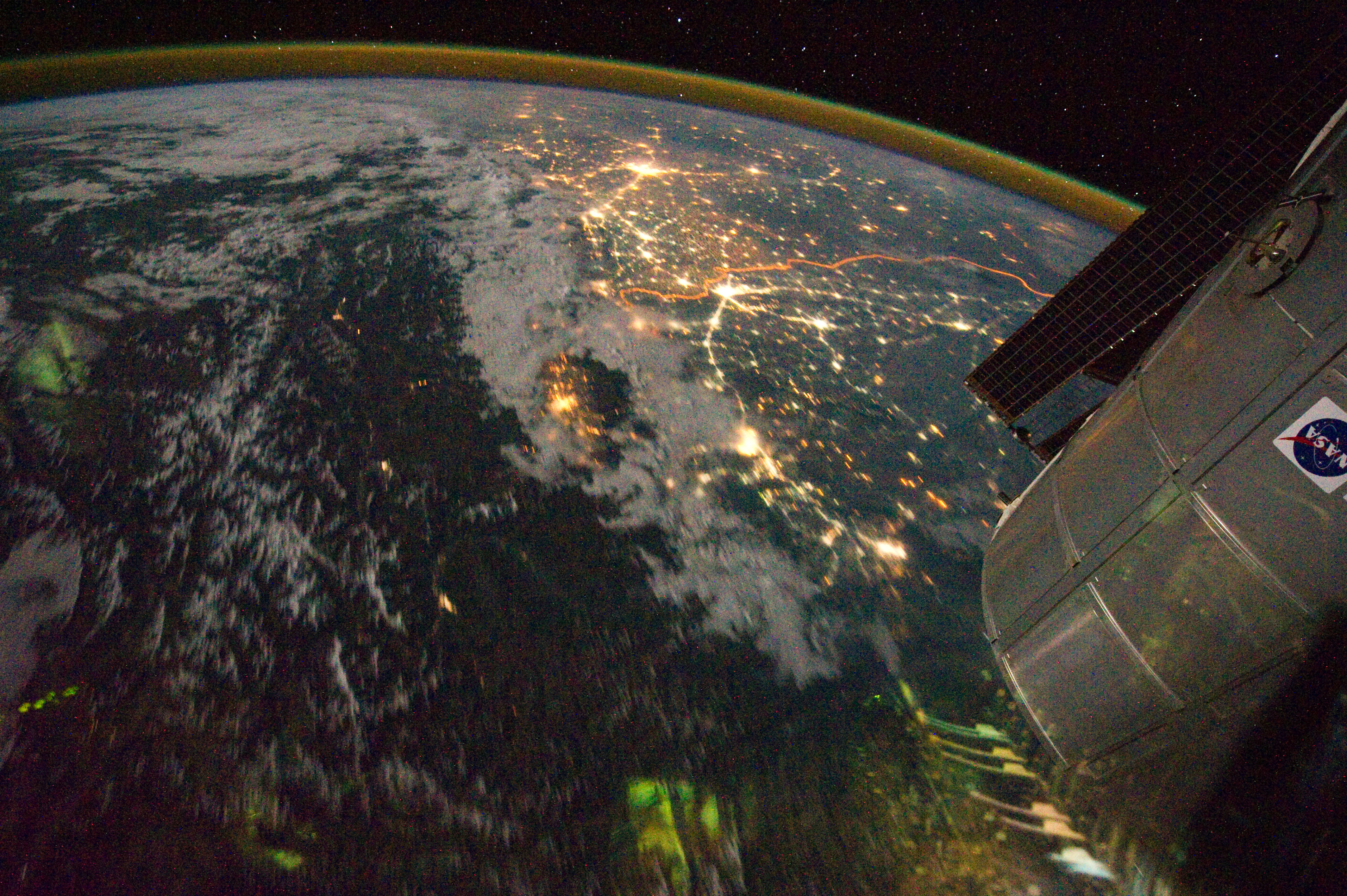
English: Clusters of yellow lights on the Indo-Gangetic Plain reveal numerous cities large and small in this astronaut photograph of northern India and northern Pakistan.
|
| दिनांक | |
| स्रोत | NASA Earth Observatory |
| लेखक | ISS Expedition 28 crew |
| कैमरा स्थान | | यह और अन्य आसपास की छवियों यहां पर देखें: ओपन स्ट्रीट मैप |
|---|
This image or video was catalogued by Johnson Space Center of the United States National Aeronautics and Space Administration (NASA) under Photo ID: ISS028-E-29679. This tag does not indicate the copyright status of the attached work. A normal copyright tag is still required. See Commons:Licensing. Other languages:
|
Image acquired with a Nikon D3S digital camera using a 16 mm lens, and is provided by the ISS Crew Earth Observations experiment and Image Science & Analysis Laboratory, Johnson Space Center.
लाइसेंस
| This file is in the public domain in the United States because it was solely created by NASA. NASA copyright policy states that "NASA material is not protected by copyright unless noted". (See Template:PD-USGov, NASA copyright policy page or JPL Image Use Policy.) | ||
 |
Warnings:
|
| Annotations | This image is annotated: View the annotations at Commons |
चित्र का इतिहास
फ़ाइलका पुराना अवतरण देखने के लिये दिनांक/समय पर क्लिक करें।
| दिनांक/समय | थंबनेल | आकार | सदस्य | प्रतिक्रिया | |
|---|---|---|---|---|---|
| वर्तमान | 15:03, 6 सितंबर 2011 | | 4,256 × 2,832 (3.11 MB) | Originalwana | {{Information |Description ={{en|1=Clusters of yellow lights on the Indo-Gangetic Plain reveal numerous cities large and small in this astronaut photograph of northern India and northern Pakistan. Of the hundreds of clusters, t |
चित्र का उपयोग
निम्नलिखित पन्ने इस चित्र से जुडते हैं :
चित्र का वैश्विक उपयोग
इस चित्र का उपयोग इन दूसरे विकियों में किया जाता है:
- ar.wikipedia.org पर उपयोग
- bh.wikipedia.org पर उपयोग
- bn.wikipedia.org पर उपयोग
- ca.wikipedia.org पर उपयोग
- en.wikipedia.org पर उपयोग
- sl.wikipedia.org पर उपयोग
- sr.wikipedia.org पर उपयोग
- ta.wikipedia.org पर उपयोग
- te.wikipedia.org पर उपयोग
- uk.wikipedia.org पर उपयोग
- vi.wikipedia.org पर उपयोग