
चित्र:China India eastern border 88.jpg

इस पूर्वावलोकन का आकार: 483 × 600 पिक्सेल। दूसरे रेसोल्यूशन्स: 193 × 240 पिक्सेल | 387 × 480 पिक्सेल | 1,019 × 1,265 पिक्सेल।
मूल चित्र ((1,019 × 1,265 पिक्सेल, फ़ाइल का आकार: 297 KB, MIME प्रकार: image/jpeg))
|
|
यह फ़ाइल विकिमेडिया कॉमन्स से है। वहाँ पर इसका विवरण पृष्ठ निम्नोक्त है। कॉमन्स मुक्त लाइसेंसों के अंतर्गत उपलब्ध मीडिया फ़ाइलों का संग्रह है। आप भी इसमें मदद कर सकते हैं। |
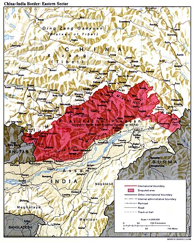
| विवरण | China India eastern border depicting disputed areas in this sector including NEFA. | |||
| दिनांक | ||||
| स्रोत | http://www.lib.utexas.edu/maps/middle_east_and_asia/china_india_e_border_88.jpg | |||
| लेखक | Central Intelligence Agency | |||
| अनुमति (इस चित्र का पुनः उपयोग करना) |
|
|||
| दूसरे संस्करण |
 |

| Annotations | This image is annotated: View the annotations at Commons |
चित्र का इतिहास
फ़ाइलका पुराना अवतरण देखने के लिये दिनांक/समय पर क्लिक करें।
| दिनांक/समय | थंबनेल | आकार | सदस्य | प्रतिक्रिया | |
|---|---|---|---|---|---|
| वर्तमान | 04:59, 2 अप्रैल 2007 | | 1,019 × 1,265 (297 KB) | Yuje | China India eastern border depicting disputed areas in this sector including NEFA. Taken from [http://www.lib.utexas.edu/maps/middle_east_and_asia/china_indiae_border_88.jpg] |
चित्र का उपयोग
निम्नलिखित पन्ने इस चित्र से जुडते हैं :
चित्र का वैश्विक उपयोग
इस चित्र का उपयोग इन दूसरे विकियों में किया जाता है:
- as.wikipedia.org पर उपयोग
- bn.wikipedia.org पर उपयोग
- cs.wikipedia.org पर उपयोग
- de.wikipedia.org पर उपयोग
- en.wikipedia.org पर उपयोग
- es.wikipedia.org पर उपयोग
- fa.wikipedia.org पर उपयोग
- fr.wikipedia.org पर उपयोग
- gu.wikipedia.org पर उपयोग
- he.wikipedia.org पर उपयोग
- hr.wikipedia.org पर उपयोग
- hu.wikipedia.org पर उपयोग
- id.wikipedia.org पर उपयोग
- it.wikipedia.org पर उपयोग
- ja.wikipedia.org पर उपयोग
- kn.wikipedia.org पर उपयोग
- ko.wikipedia.org पर उपयोग
- ky.wikipedia.org पर उपयोग
- lt.wikipedia.org पर उपयोग
- ms.wikipedia.org पर उपयोग
- ne.wikipedia.org पर उपयोग
- nl.wikipedia.org पर उपयोग
- pa.wikipedia.org पर उपयोग
- pl.wikipedia.org पर उपयोग
- pnb.wikipedia.org पर उपयोग
- pt.wikipedia.org पर उपयोग
इस चित्र के वैश्विक उपयोग की अधिक जानकारी देखें।