
चित्र:Arabische Eroberung 2.jpg

इस पूर्वावलोकन का आकार: 800 × 506 पिक्सेल। दूसरे रेसोल्यूशन्स: 320 × 202 पिक्सेल | 640 × 404 पिक्सेल | 1,024 × 647 पिक्सेल | 1,280 × 809 पिक्सेल | 2,560 × 1,618 पिक्सेल | 4,496 × 2,841 पिक्सेल।
मूल चित्र ((4,496 × 2,841 पिक्सेल, फ़ाइल का आकार: 3.36 MB, MIME प्रकार: image/jpeg))
|
|
यह फ़ाइल विकिमेडिया कॉमन्स से है। वहाँ पर इसका विवरण पृष्ठ निम्नोक्त है। कॉमन्स मुक्त लाइसेंसों के अंतर्गत उपलब्ध मीडिया फ़ाइलों का संग्रह है। आप भी इसमें मदद कर सकते हैं। |
सारांश
| विवरण |
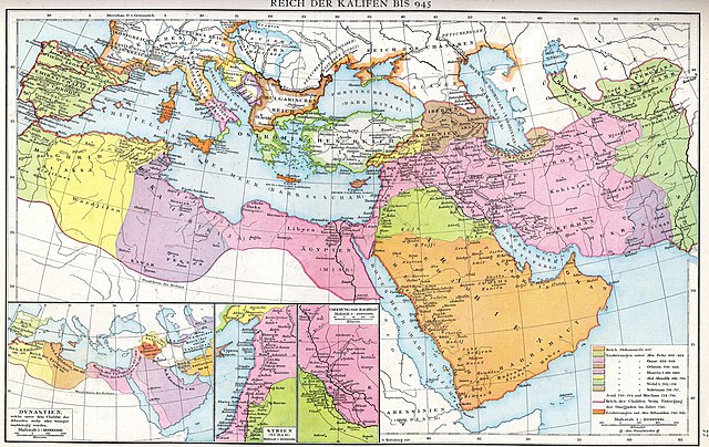
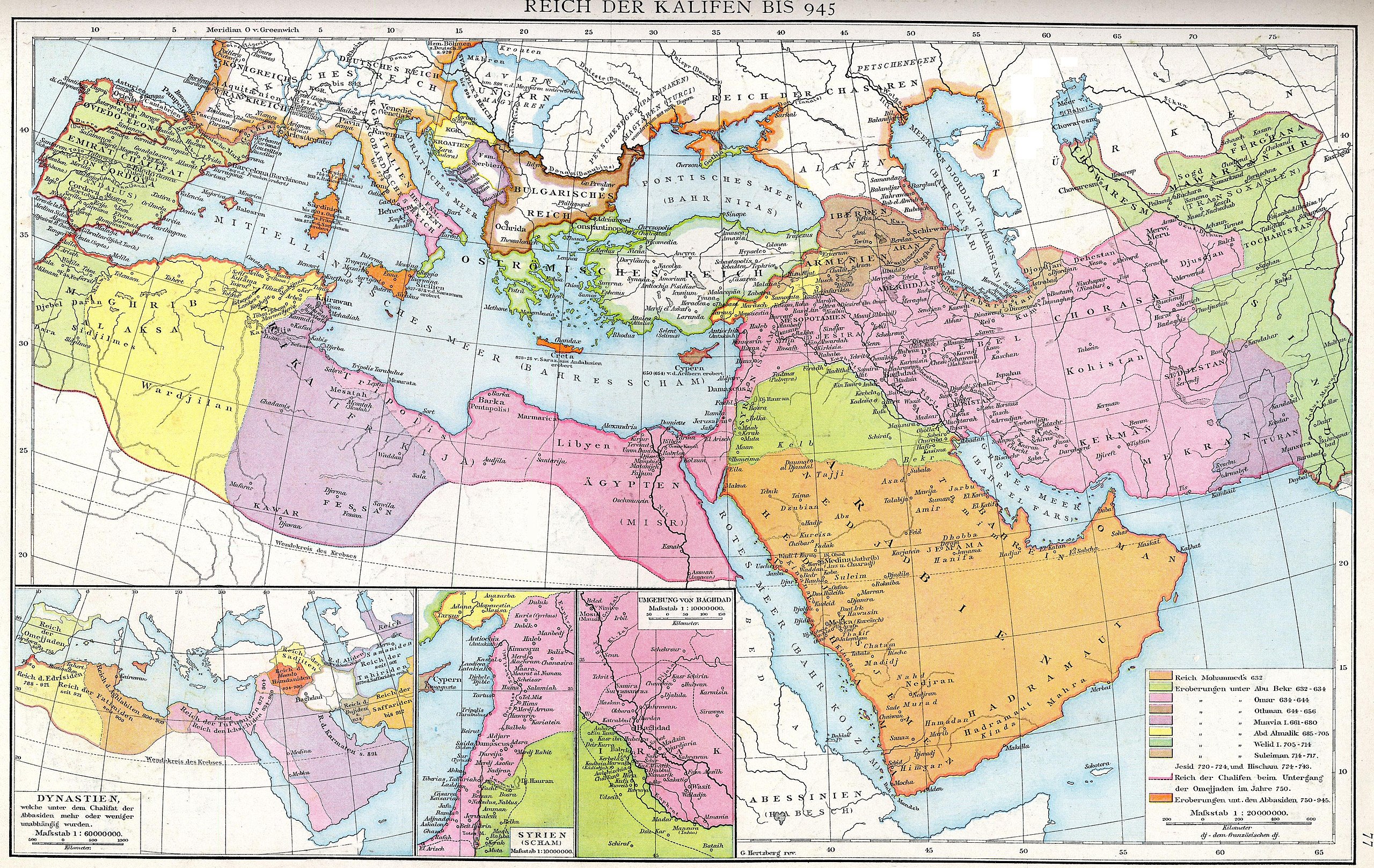
Deutsch: Das Reich der Kalifen bis 945. Karte aus dem Historischen Handatlas von Gustav Droysen, 1886
English: The empire of the Caliphs to 945. Map of the Historical Atlas of Gustav Droysen, 1886 |
| दिनांक | |
| स्रोत | Gustav Droysens Allgemeiner historischer Handatlas in 96 Karten mit erläuterndem Text Bielefeld [u.a.]: Velhagen & Klasing 1886, S. 77. |
| लेखक | Johann Gustav Droysen (6 July 1808 – 19 June 1884) |
| दूसरे संस्करण |
Derivative works of this file: |
.jpg)
लाइसेंस
|
This work is in the public domain in its country of origin and other countries and areas where the copyright term is the author's life plus 100 years or fewer. This work is in the public domain in the United States because it was published (or registered with the U.S. Copyright Office) before January 1, 1929. | |
| इस फ़ाइल को कॉपीराइट कानूनों के अंतर्गत सभी संबंधित अधिकारों समेत ज्ञात सीमाओं से मुक्त पहचाना गया है। | |
चित्र का इतिहास
फ़ाइलका पुराना अवतरण देखने के लिये दिनांक/समय पर क्लिक करें।
| दिनांक/समय | थंबनेल | आकार | सदस्य | प्रतिक्रिया | |
|---|---|---|---|---|---|
| वर्तमान | 13:23, 10 अगस्त 2012 | | 4,496 × 2,841 (3.36 MB) | Cplakidas | larger & better quality |
| 00:51, 24 फ़रवरी 2007 |  | 2,187 × 1,389 (754 KB) | Nikephoros | {{Information |Description=Karte des Kalifates vom Tode Mohammeds bis 945 |Source=Professor G. Droysens Allgemeiner Historischer Handatlas |Date=1886 |Author=G. Droysen |Permission=not necessary |other_versions= }} |
चित्र का उपयोग
इस चित्र से कोई पन्ने नहीं जुड़ते
चित्र का वैश्विक उपयोग
इस चित्र का उपयोग इन दूसरे विकियों में किया जाता है:
- ar.wikipedia.org पर उपयोग
- az.wikipedia.org पर उपयोग
- de.wikipedia.org पर उपयोग
- de.wikiversity.org पर उपयोग
- el.wikipedia.org पर उपयोग
- en.wikipedia.org पर उपयोग
- Mu'awiya I
- Al-Mu'tasim
- Al-Mada'in
- Abbasid invasion of Asia Minor (806)
- Fourth Fitna
- User:Al Ameer son/Abd al-Malik
- User:Al Ameer son/Al-Walid I
- User:Al Ameer son/Sulayman
- User:Al Ameer son/Umayyad Caliphate
- Wikipedia:Graphics Lab/Map workshop/Archive/Apr 2023
- User:Falcaorib/Medieval Empires (800-1000 AD)
- es.wikipedia.org पर उपयोग
- fa.wikibooks.org पर उपयोग
- fr.wikipedia.org पर उपयोग
- id.wikipedia.org पर उपयोग
- it.wikipedia.org पर उपयोग
- ja.wikipedia.org पर उपयोग
- ka.wikipedia.org पर उपयोग
- sl.wikipedia.org पर उपयोग
- sq.wikipedia.org पर उपयोग
- sr.wikipedia.org पर उपयोग
- tr.wikipedia.org पर उपयोग
- ur.wikipedia.org पर उपयोग
- uz.wikipedia.org पर उपयोग
- zh.wikipedia.org पर उपयोग