
चित्र:UK Radar1940.JPG

इस पूर्वावलोकन का आकार: 502 × 599 पिक्सेल। दूसरे रेसोल्यूशन्स: 201 × 240 पिक्सेल | 402 × 480 पिक्सेल | 644 × 768 पिक्सेल | 858 × 1,024 पिक्सेल | 1,400 × 1,670 पिक्सेल।
मूल चित्र ((1,400 × 1,670 पिक्सेल, फ़ाइल का आकार: 304 KB, MIME प्रकार: image/jpeg))
|
|
यह फ़ाइल विकिमेडिया कॉमन्स से है। वहाँ पर इसका विवरण पृष्ठ निम्नोक्त है। कॉमन्स मुक्त लाइसेंसों के अंतर्गत उपलब्ध मीडिया फ़ाइलों का संग्रह है। आप भी इसमें मदद कर सकते हैं। |
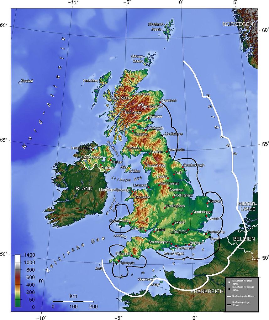
The map (topographic background derived from a German article about Great Britain taken from German wikipedia) gives a quick overview about British radar facilities during the Battle for Britain 1940. I drew the map myself (thats the reason, why it looks quite improvised). Nasiruddin 16:27, 15 August 2005 (UTC)
- Explanation of German legend: White squares indicate high-altitude radar stations, black squares, low-altitude stations. The white line indicates the range of the high-altitude radar, the black line, the range of the low altitude radar.
- other versions =


- other versions =


The map has been created with the Generic Mapping Tools: https://www.generic-mapping-tools.org/ using one or more of these public-domain datasets for the relief:
|

|
इस दस्तावेज़ को Free Software Foundation द्वारा प्रकाशित GNU मुक्त प्रलेख लाइसेंस के संस्करण 1.2 या नए (बिना किसी अपरिवर्तनीय अनुभागों और अगले या पिछले आवरण के टेक्स्ट के) के अंतर्गत प्रतिलिपि बनाने, बाँटने और/या बदलने की अनुमति प्रदान की जाती है। इस लाइसेंस की एक प्रतिलिपि GNU मुक्त प्रलेख लाइसेंस नामक अनुभाग में शामिल है। |
| इस फ़ाइल को क्रिएटिव कॉमन्स श्रेय-समानसांझा 3.0 अनरिपोर्टेड लाइसेंस के अंतर्गत लाइसेंस किया गया है। | ||
| ||
| This licensing tag was added to this file as part of the GFDL licensing update. |
चित्र का इतिहास
फ़ाइलका पुराना अवतरण देखने के लिये दिनांक/समय पर क्लिक करें।
| दिनांक/समय | थंबनेल | आकार | सदस्य | प्रतिक्रिया | |
|---|---|---|---|---|---|
| वर्तमान | 16:27, 15 अगस्त 2005 | | 1,400 × 1,670 (304 KB) | Nasiruddin | The map (topographic background derived from a German article about Great Britain taken from German wikipedia) gives a quick overview about British radar facilities during the Battle for Britain 1940. I drew the map myself (thats the reason, why it looks |
चित्र का उपयोग
निम्नलिखित पन्ने इस चित्र से जुडते हैं :
चित्र का वैश्विक उपयोग
इस चित्र का उपयोग इन दूसरे विकियों में किया जाता है:
- ca.wikipedia.org पर उपयोग
- de.wikipedia.org पर उपयोग
- fi.wikipedia.org पर उपयोग
- fr.wikipedia.org पर उपयोग
- hu.wikipedia.org पर उपयोग
- ko.wikipedia.org पर उपयोग
- pt.wikipedia.org पर उपयोग
- sv.wikipedia.org पर उपयोग
- vi.wikipedia.org पर उपयोग