
चित्र:Yamama english.jpg

इस पूर्वावलोकन का आकार: 800 × 457 पिक्सेल। दूसरे रेसोल्यूशन्स: 320 × 183 पिक्सेल | 640 × 366 पिक्सेल | 1,024 × 585 पिक्सेल | 1,661 × 949 पिक्सेल।
मूल चित्र ((1,661 × 949 पिक्सेल, फ़ाइल का आकार: 819 KB, MIME प्रकार: image/jpeg))
|
|
यह फ़ाइल विकिमेडिया कॉमन्स से है। वहाँ पर इसका विवरण पृष्ठ निम्नोक्त है। कॉमन्स मुक्त लाइसेंसों के अंतर्गत उपलब्ध मीडिया फ़ाइलों का संग्रह है। आप भी इसमें मदद कर सकते हैं। |
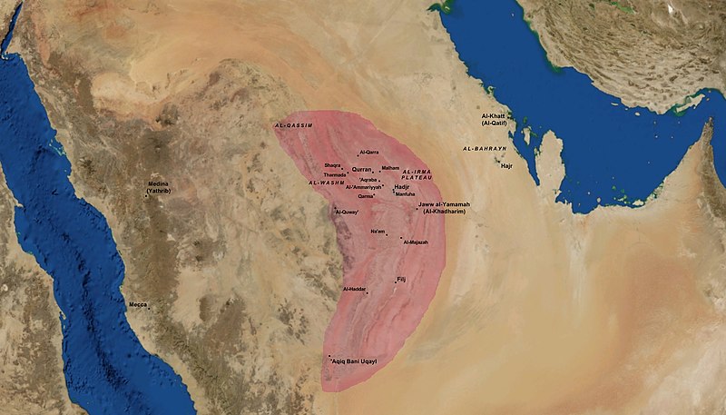
The historical province of Al-Yamamah at its greatest extent, as described by Yaqut and Al-Hamadani.
| This image is in the public domain because it is a screenshot from NASA’s globe software World Wind using a public domain layer, such as Blue Marble, MODIS, Landsat, SRTM, USGS or GLOBE.
|
 |
चित्र का इतिहास
फ़ाइलका पुराना अवतरण देखने के लिये दिनांक/समय पर क्लिक करें।
| दिनांक/समय | थंबनेल | आकार | सदस्य | प्रतिक्रिया | |
|---|---|---|---|---|---|
| वर्तमान | 21:26, 15 जून 2007 | | 1,661 × 949 (819 KB) | Slackerlawstudent~commonswiki | The historical province of Al-Yamamah at its greatest extent, as described by Yaqut and Al-Hamadani. {{PD-WorldWind}} Category:Maps of Saudi Arabia |
चित्र का उपयोग
निम्नलिखित पन्ने इस चित्र से जुडते हैं :
चित्र का वैश्विक उपयोग
इस चित्र का उपयोग इन दूसरे विकियों में किया जाता है:
- bn.wikipedia.org पर उपयोग
- ca.wikipedia.org पर उपयोग
- de.wikipedia.org पर उपयोग
- en.wikipedia.org पर उपयोग
- es.wikipedia.org पर उपयोग
- fa.wikipedia.org पर उपयोग
- fr.wikipedia.org पर उपयोग
- ha.wikipedia.org पर उपयोग
- id.wikipedia.org पर उपयोग
- it.wikipedia.org पर उपयोग
- ja.wikipedia.org पर उपयोग
- ml.wikipedia.org पर उपयोग
- pt.wikipedia.org पर उपयोग
- ru.wikipedia.org पर उपयोग
- sr.wikipedia.org पर उपयोग
- tr.wikipedia.org पर उपयोग
- uk.wikipedia.org पर उपयोग
- www.wikidata.org पर उपयोग
- zh.wikipedia.org पर उपयोग