
चित्र:USA Counties.svg

पूर्वावलोकन PNG का आकार SVG फ़ाइल: 555 × 352 पिक्सेल दूसरे रेसोल्यूशन्स: 320 × 203 पिक्सेल | 640 × 406 पिक्सेल | 1,024 × 649 पिक्सेल | 1,280 × 812 पिक्सेल | 2,560 × 1,624 पिक्सेल।
मूल चित्र (SVG फ़ाइल, साधारणतः 555 × 352 पिक्सेल, फ़ाइल का आकार: 1.11 MB)
|
|
यह फ़ाइल विकिमेडिया कॉमन्स से है। वहाँ पर इसका विवरण पृष्ठ निम्नोक्त है। कॉमन्स मुक्त लाइसेंसों के अंतर्गत उपलब्ध मीडिया फ़ाइलों का संग्रह है। आप भी इसमें मदद कर सकते हैं। |

|
इस फ़ाइल को Usa counties large.svg द्वारा अधिक्रमित कर दिया गया है। दूसरे फ़ाइल का इस्तेमाल करने सुझाया जाता है। कृपया ध्यान रखें कि अधिक्रमित चित्रों को हटाने के लिए अनुमति की ज़रबरत है। दूसरे फ़ाइल का इस्तेमाल करने का कारण: "Contains county names and county codes in the svg code"
|

|
| विवरण |
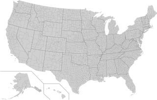
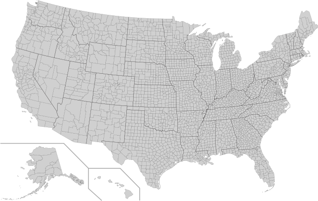
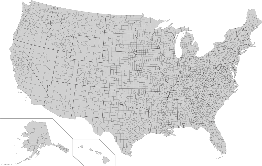
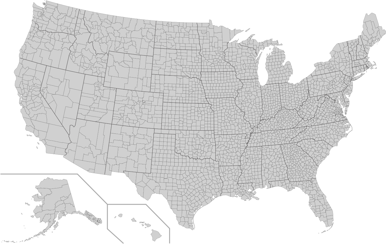
English: This is a map of the United States showing the borders of states and counties in high detail. |
|||
| स्रोत |
It was derived from this public-domain document published by the U.S. Census Bureau. |
|||
| लेखक | U.S. Census Bureau | |||
| अनुमति (इस चित्र का पुनः उपयोग करना) |
|
|||
| दूसरे संस्करण | Derivative works of this file: Usa counties large.svg | |||
| SVG genesis | इस वेक्टर चित्र को Inkscape की मदद से बनाया गया था। |

चित्र का इतिहास
फ़ाइलका पुराना अवतरण देखने के लिये दिनांक/समय पर क्लिक करें।
| दिनांक/समय | थंबनेल | आकार | सदस्य | प्रतिक्रिया | |
|---|---|---|---|---|---|
| वर्तमान | 05:18, 10 अगस्त 2022 | | 555 × 352 (1.11 MB) | DemonDays64 | Fixed some problems: merged southern part of Unorganized Alaska into one shape; properly labeled Somerset MD, which Accomack VA had been mislabeled as |
| 06:22, 17 सितंबर 2020 |  | 555 × 352 (1.11 MB) | DemonDays64 | Fixed misspelling of "Albemarle" as "Albermarle" | |
| 15:56, 10 सितंबर 2018 |  | 555 × 352 (1.11 MB) | JoKalliauer | restored id-names and css from 03:49, 26. Mär. 2016 | |
| 06:38, 30 अगस्त 2018 |  | 555 × 352 (670 KB) | JoKalliauer | Smaller file-size. Cleaner code. valid file | |
| 03:49, 26 मार्च 2016 |  | 555 × 352 (1.58 MB) | Spesh531 | updating borders, more accurate | |
| 15:47, 23 दिसम्बर 2007 |  | 555 × 352 (2.03 MB) | Lokal Profil | Fixed state borders and fixed the two parts of Fulton County (Kentucky) | |
| 02:20, 10 दिसम्बर 2007 |  | 555 × 352 (2.04 MB) | Lokal Profil | Graphical and code cleanup | |
| 01:15, 10 दिसम्बर 2007 |  | 792 × 612 (2.04 MB) | Lokal Profil | First stab at a code cleanup | |
| 00:14, 29 अगस्त 2006 |  | 792 × 612 (2.71 MB) | Petr Dlouhý | Original file: en:Image:USA CountiesSVG.zip This ZIP file contains an SVG map of the United States showing the borders of states and counties in high detail. It was derived from [http://www2.census.gov/geo/maps/special |
चित्र का उपयोग
निम्नलिखित पन्ने इस चित्र से जुडते हैं :
चित्र का वैश्विक उपयोग
इस चित्र का उपयोग इन दूसरे विकियों में किया जाता है:
- af.wikipedia.org पर उपयोग
- en.wikipedia.org पर उपयोग
- fa.wikipedia.org पर उपयोग
- fi.wikipedia.org पर उपयोग
- he.wikipedia.org पर उपयोग
- hu.wikipedia.org पर उपयोग
- io.wikipedia.org पर उपयोग
- pnb.wikipedia.org पर उपयोग
- pt.wikipedia.org पर उपयोग
- ro.wikipedia.org पर उपयोग
- sh.wikipedia.org पर उपयोग
- sq.wikipedia.org पर उपयोग
- sr.wikipedia.org पर उपयोग
- tr.wikipedia.org पर उपयोग
- ur.wikipedia.org पर उपयोग