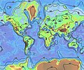
चित्र:World relief map with isopachs of crustal thickness.jpg
World_relief_map_with_isopachs_of_crustal_thickness.jpg ((636 × 532 पिक्सेल, फ़ाइल का आकार: 86 KB, MIME प्रकार: image/jpeg))
चित्र का इतिहास
फ़ाइलका पुराना अवतरण देखने के लिये दिनांक/समय पर क्लिक करें।
| दिनांक/समय | थंबनेल | आकार | सदस्य | प्रतिक्रिया | |
|---|---|---|---|---|---|
| वर्तमान | 19:34, 24 मई 2011 |  | 636 × 532 (86 KB) | HVL | Reverted to version as of 19:48, 24 January 2007 |
| 17:40, 24 मई 2011 | 500 × 200 (140 KB) | Realmau | |||
| 19:48, 24 जनवरी 2007 |  | 636 × 532 (86 KB) | Bryan | Reverted to earlier revision | |
| 19:48, 24 जनवरी 2007 |  | 636 × 532 (86 KB) | Luna90~commonswiki | Invertit amb una revisió anterior | |
| 19:47, 24 जनवरी 2007 |  | 159 × 160 (4 KB) | Luna90~commonswiki | Topo-animal | |
| 19:46, 24 जनवरी 2007 |  | 636 × 532 (86 KB) | Luna90~commonswiki | Invertit amb una revisió anterior | |
| 19:45, 24 जनवरी 2007 |  | 159 × 160 (4 KB) | Luna90~commonswiki | Topo-animal | |
| 22:00, 18 जुलाई 2006 |  | 636 × 532 (86 KB) | Zimbres | {{Information |Description= A contour map of the thickness of the Earth's crust. |Source=http://quake.wr.usgs.gov/research/structure/CrustalStructure/abstract.html |Date= |Author= USGS/USGov |Permission=Free for all use |other_versions= }} [[Category:Tec |
चित्र का उपयोग
निम्नलिखित पन्ने इस चित्र से जुडते हैं :
चित्र का वैश्विक उपयोग
इस चित्र का उपयोग इन दूसरे विकियों में किया जाता है:
- af.wikipedia.org पर उपयोग
- ar.wikipedia.org पर उपयोग
- az.wikipedia.org पर उपयोग
- bg.wikipedia.org पर उपयोग
- bh.wikipedia.org पर उपयोग
- de.wikipedia.org पर उपयोग
- en.wikipedia.org पर उपयोग
- en.wikiversity.org पर उपयोग
- es.wikipedia.org पर उपयोग
- et.wikipedia.org पर उपयोग
- eu.wikipedia.org पर उपयोग
- fa.wikipedia.org पर उपयोग
- fi.wikipedia.org पर उपयोग
- fr.wikipedia.org पर उपयोग
- gl.wikipedia.org पर उपयोग
- id.wikipedia.org पर उपयोग
- is.wikipedia.org पर उपयोग
- it.wikipedia.org पर उपयोग
- it.wikibooks.org पर उपयोग
- lv.wikipedia.org पर उपयोग
- mk.wikipedia.org पर उपयोग
- nds.wikipedia.org पर उपयोग
- nl.wikipedia.org पर उपयोग
- pl.wikipedia.org पर उपयोग
- pt.wikipedia.org पर उपयोग
- ru.wikipedia.org पर उपयोग
- simple.wikipedia.org पर उपयोग
- sk.wikipedia.org पर उपयोग
- sl.wikipedia.org पर उपयोग
- sr.wikipedia.org पर उपयोग
- sv.wikipedia.org पर उपयोग
- te.wikipedia.org पर उपयोग
- th.wikipedia.org पर उपयोग
- tr.wikipedia.org पर उपयोग
- uk.wikipedia.org पर उपयोग
- uk.wikibooks.org पर उपयोग
इस चित्र के वैश्विक उपयोग की अधिक जानकारी देखें।


