
चित्र:Thraciae-veteris-typvs.jpg
इस पूर्वावलोकन का आकार: 780 × 600 पिक्सेल। दूसरे रेसोल्यूशन्स: 312 × 240 पिक्सेल | 624 × 480 पिक्सेल | 999 × 768 पिक्सेल | 1,280 × 984 पिक्सेल | 2,560 × 1,969 पिक्सेल | 4,452 × 3,424 पिक्सेल।
मूल चित्र ((4,452 × 3,424 पिक्सेल, फ़ाइल का आकार: 3.59 MB, MIME प्रकार: image/jpeg))
|
|
यह फ़ाइल विकिमेडिया कॉमन्स से है। वहाँ पर इसका विवरण पृष्ठ निम्नोक्त है। कॉमन्स मुक्त लाइसेंसों के अंतर्गत उपलब्ध मीडिया फ़ाइलों का संग्रह है। आप भी इसमें मदद कर सकते हैं। |
सारांश
| विवरण |
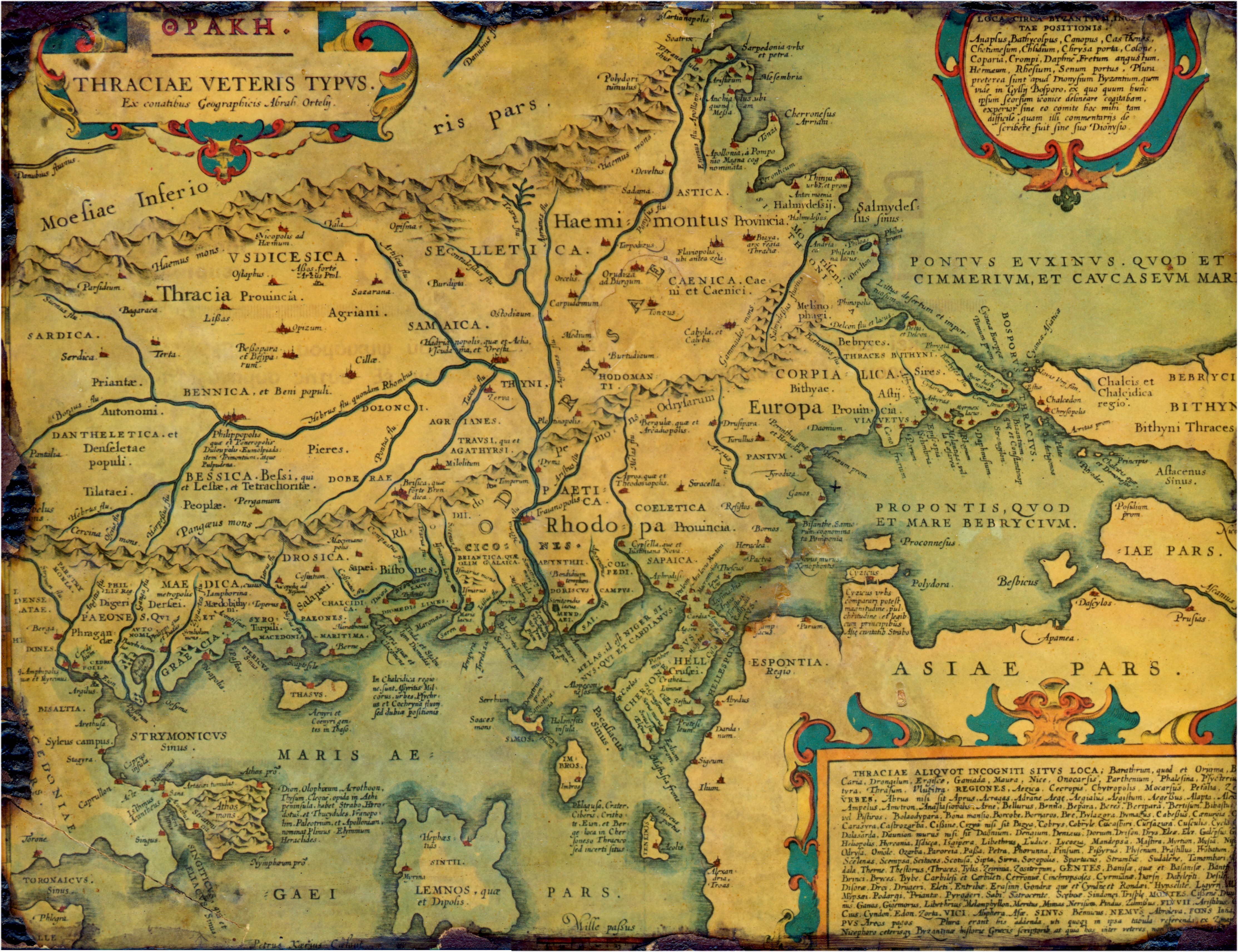
English: Old, historical map of ancient Thrace, mostly in Latin and very few Greek, made in 1585. The map also shows part of Asia minor, Moesia inferior, & ancient Greece along with some Aegan islands. There is some anachronism on the map, such as Moesia inferior and other features.
Français : Vieille carte historique de la Thrace antique, principalement en latin avec un petit peu de grec, faite en 1585. La carte montre également une partie de l'Asie mineure, la Mésie inférieure, et la Grèce antique avec quelques îles égéennes. Il y a des anachronismes sur la carte, tels que la Mésie inférieure et d'autres caractéristiques. |
|||||||||||||||||||||||
| दिनांक | ||||||||||||||||||||||||
| स्रोत | Thraciae veteris typvs . . . 1585 | |||||||||||||||||||||||
| लेखक |
|
|||||||||||||||||||||||
| अनुमति (इस चित्र का पुनः उपयोग करना) |
PD-Art | |||||||||||||||||||||||

लाइसेंस
|
This is a faithful photographic reproduction of a two-dimensional, public domain work of art. The work of art itself is in the public domain for the following reason:
The official position taken by the Wikimedia Foundation is that "faithful reproductions of two-dimensional public domain works of art are public domain".
This photographic reproduction is therefore also considered to be in the public domain in the United States. In other jurisdictions, re-use of this content may be restricted; see Reuse of PD-Art photographs for details. | ||||
इस चित्र का चित्र गुणवत्ता निर्देशों की कसौटी पर मूल्यांकन किया गया है और इसे एक गुणवत्तायुक्त चित्र माना जाता है।
|
चित्र का इतिहास
फ़ाइलका पुराना अवतरण देखने के लिये दिनांक/समय पर क्लिक करें।
| दिनांक/समय | थंबनेल | आकार | सदस्य | प्रतिक्रिया | |
|---|---|---|---|---|---|
| वर्तमान | 21:58, 12 जुलाई 2006 | | 4,452 × 3,424 (3.59 MB) | Adamantios | {{Information |Description=Old, historical map of Thrace. |Source=copy of framed gravure |Date=copied on July of 2006 |Author=unknown |Permission=PD-old |other_versions= }} Category:Old maps of the Balkans Category:History of the Balkans |
चित्र का उपयोग
निम्नलिखित पन्ने इस चित्र से जुडते हैं :
चित्र का वैश्विक उपयोग
इस चित्र का उपयोग इन दूसरे विकियों में किया जाता है:
- ast.wikipedia.org पर उपयोग
- bg.wikipedia.org पर उपयोग
- br.wikipedia.org पर उपयोग
- ca.wikipedia.org पर उपयोग
- cs.wikipedia.org पर उपयोग
- da.wikipedia.org पर उपयोग
- de.wikipedia.org पर उपयोग
- el.wikipedia.org पर उपयोग
- en.wikipedia.org पर उपयोग
- Aegospotami
- Thrace
- Perinthus
- Plovdiv
- Thynia
- Ismarus (Thrace)
- Dionysupolis
- Agora (Thrace)
- Zerynthus
- Delkos
- Heraclea Sintica
- Apollonia (Kavala)
- Bisanthe
- Bergule
- Galepsus (Thrace)
- List of ancient cities in Thrace and Dacia
- List of kings of Thrace and Dacia
- Pistyrus
- Crenides (Macedonia)
- Myrcinus
- Neapolis (Thrace)
- Oesyme
- Sirra
- Bergepolis
- Larissa (Homeric city)
- Sale (Thrace)
- Stryme
- Drys (Thrace)
- Dicaea (Thrace)
- Cypsela (Thrace)
- Orthagoria
- Zone (colony)
- Araplus
- Alopeconnesus
- Deris (Thrace)
- Pactya
- Ide (Thracian Chersonese)
इस चित्र के वैश्विक उपयोग की अधिक जानकारी देखें।