
चित्र:Soviet Union Administrative Divisions 1989.jpg

इस पूर्वावलोकन का आकार: 800 × 557 पिक्सेल। दूसरे रेसोल्यूशन्स: 320 × 223 पिक्सेल | 640 × 445 पिक्सेल | 1,024 × 713 पिक्सेल | 1,280 × 891 पिक्सेल | 1,887 × 1,313 पिक्सेल।
मूल चित्र ((1,887 × 1,313 पिक्सेल, फ़ाइल का आकार: 397 KB, MIME प्रकार: image/jpeg))
|
|
यह फ़ाइल विकिमेडिया कॉमन्स से है। वहाँ पर इसका विवरण पृष्ठ निम्नोक्त है। कॉमन्स मुक्त लाइसेंसों के अंतर्गत उपलब्ध मीडिया फ़ाइलों का संग्रह है। आप भी इसमें मदद कर सकते हैं। |
सारांश
| विवरण |
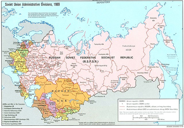
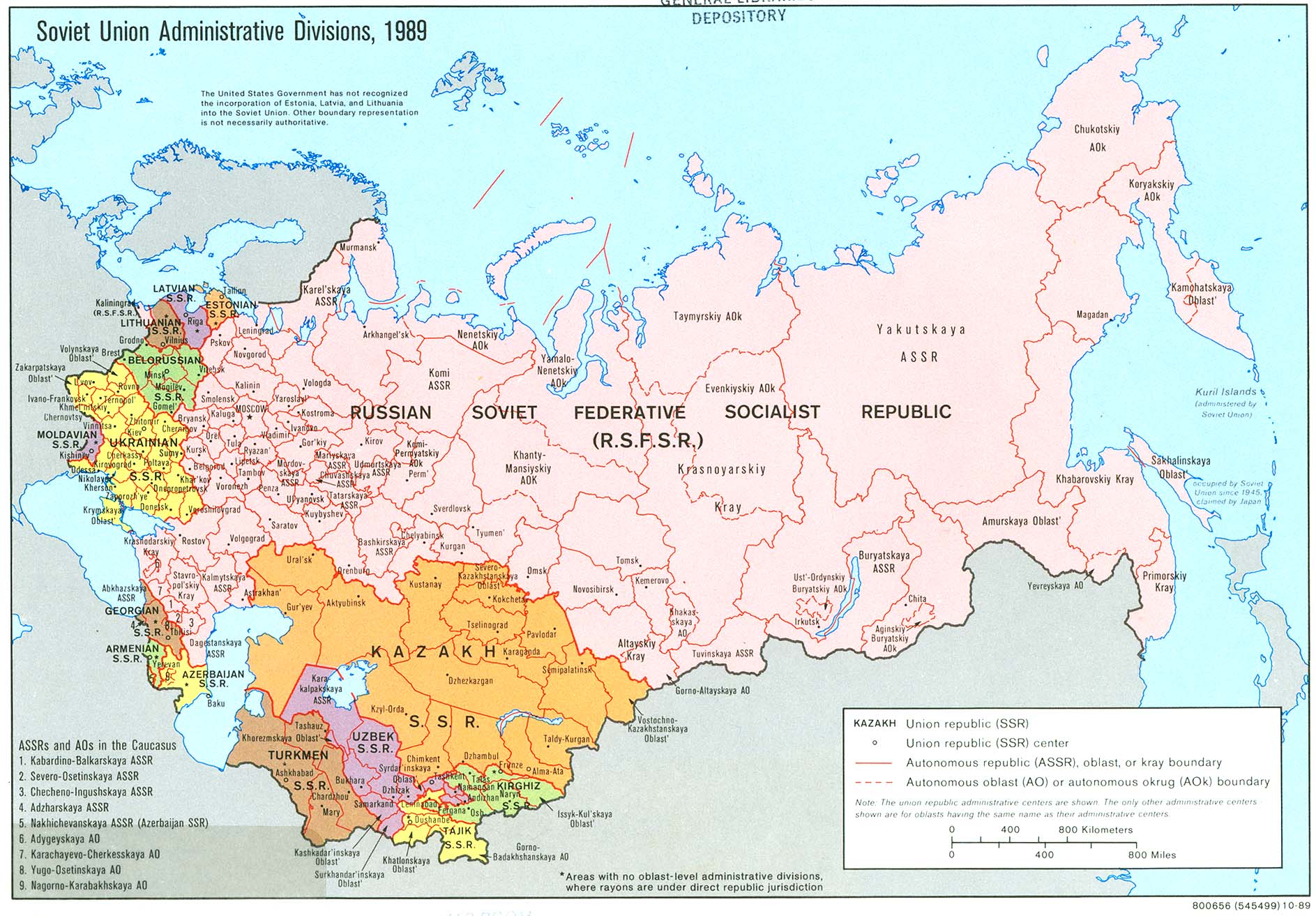
English: An American map of Soviet Union Administrative Divisions c.1989 |
||
| स्रोत |
|
||
| लेखक | |||
| दूसरे संस्करण |
|


लाइसेंस
| This work is from the Library of Congress. According to the library, there are no known copyright restrictions on the use of this work. |  |
चित्र का इतिहास
फ़ाइलका पुराना अवतरण देखने के लिये दिनांक/समय पर क्लिक करें।
| दिनांक/समय | थंबनेल | आकार | सदस्य | प्रतिक्रिया | |
|---|---|---|---|---|---|
| वर्तमान | 14:21, 17 मई 2019 | | 1,887 × 1,313 (397 KB) | Claude Zygiel | Removed stains |
| 07:39, 17 दिसम्बर 2006 |  | 1,887 × 1,313 (413 KB) | Electionworld | {{ew|en|Ma GioZal}} Soviet Union administrative divisions (republics) and sub-divisions (oblasts, autonomous republics, autonomous districs, etc.) in the year 1989, the last before the process of independence of Soviet republics after the [[Berlin Wa |
चित्र का उपयोग
निम्नलिखित पन्ने इस चित्र से जुडते हैं :
चित्र का वैश्विक उपयोग
इस चित्र का उपयोग इन दूसरे विकियों में किया जाता है:
- af.wikipedia.org पर उपयोग
- ar.wikipedia.org पर उपयोग
- ast.wikipedia.org पर उपयोग
- azb.wikipedia.org पर उपयोग
- az.wikipedia.org पर उपयोग
- az.wiktionary.org पर उपयोग
- bg.wikipedia.org पर उपयोग
- ca.wikipedia.org पर उपयोग
- cs.wikipedia.org पर उपयोग
- en.wikipedia.org पर उपयोग
- History of the Soviet Union (1982–1991)
- History of Russia
- Soviet Union
- Republics of the Soviet Union
- Buryats
- Ukrainian Soviet Socialist Republic
- Uzbek Soviet Socialist Republic
- Republics of Russia
- Soviet people
- Portal:Maps/Maps/Political
- Portal:Maps/Maps/Political/8
- User:Seryo93/USSR
- Russian Soviet Federative Socialist Republic
- Portal:Soviet Union
- Great Russian chauvinism
- Russia–Ukraine border
- Russian imperialism
- User:Falcaorib
- en.wikiquote.org पर उपयोग
- es.wikipedia.org पर उपयोग
- fa.wikipedia.org पर उपयोग
- fi.wikipedia.org पर उपयोग
इस चित्र के वैश्विक उपयोग की अधिक जानकारी देखें।