
चित्र:OAPEC Members.png
इस पूर्वावलोकन का आकार: 800 × 458 पिक्सेल। दूसरे रेसोल्यूशन्स: 320 × 183 पिक्सेल | 825 × 472 पिक्सेल।
मूल चित्र ((825 × 472 पिक्सेल, फ़ाइल का आकार: 31 KB, MIME प्रकार: image/png))
|
|
यह फ़ाइल विकिमेडिया कॉमन्स से है। वहाँ पर इसका विवरण पृष्ठ निम्नोक्त है। कॉमन्स मुक्त लाइसेंसों के अंतर्गत उपलब्ध मीडिया फ़ाइलों का संग्रह है। आप भी इसमें मदद कर सकते हैं। |
| विवरण |
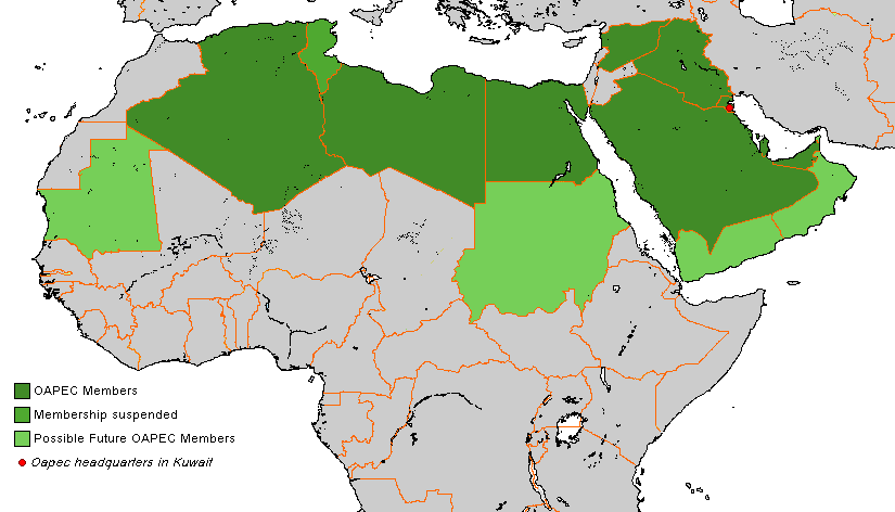
English: Oapec members... with current suspended and possible members |
| दिनांक | १६ अगस्त २००७ (original upload date) |
| स्रोत | Transferred from en.wikipedia to Commons by Leyo using CommonsHelper. |
| लेखक | अंग्रेज़ी विकिपीडिया पर Arab League |
लाइसेंस
| इस कार्य को इसके लेखक, अंग्रेज़ी विकिपीडिया पर Arab League द्वारा सार्वजनिक डोमेन में प्रकाशित किया गया है। यह पूरे विश्व में लागू होता है। कुछ देशों में यह कानूनी तौर पर नहीं हो सकता है; ऐसा हो तो: Arab League सभी को इस कार्य का इस्तेमाल किसी भी उद्देश्य से, बिना किसी बाधाओं के इन शर्तों के कानून द्वारा अनिवार्य किए तक करने की अनुमति देता/देती हैं। |
मूल अपलोड लॉग
The original description page was here. All following user names refer to en.wikipedia.
- 2007-08-16 14:39 Arab League 825×472× (35021 bytes)
- 2007-08-16 14:24 Arab League 825×472× (35044 bytes) Oapec members... with current suspended and possible members

|
This organization map image could be re-created using vector graphics as an SVG file. This has several advantages; see Commons:Media for cleanup for more information. If an SVG form of this image is available, please upload it and afterwards replace this template with
{{vector version available|new image name}}.
It is recommended to name the SVG file “OAPEC Members.svg”—then the template Vector version available (or Vva) does not need the new image name parameter. |
चित्र का इतिहास
फ़ाइलका पुराना अवतरण देखने के लिये दिनांक/समय पर क्लिक करें।
| दिनांक/समय | थंबनेल | आकार | सदस्य | प्रतिक्रिया | |
|---|---|---|---|---|---|
| वर्तमान | 11:15, 7 मार्च 2018 | | 825 × 472 (31 KB) | Maphobbyist | Check |
| 12:18, 6 मार्च 2018 |  | 825 × 472 (34 KB) | Maphobbyist | Modern borders of Turkey, because Hatay Province is part of Turkey since 1939 and borders of South Sudan which became independent in 2011. | |
| 20:58, 28 अप्रैल 2015 |  | 825 × 472 (29 KB) | Maproom | Reverted to version as of 01:02, 3 July 2010 | |
| 20:56, 28 अप्रैल 2015 |  | 825 × 472 (27 KB) | Maproom | Greyed Sudan, as requested English-Wikipedia Help Desk: https://en.wikipedia.org/wiki/Wikipedia:Graphics_Lab/Map_workshop#OAPAC_members_-_South_Sudan | |
| 01:02, 3 जुलाई 2010 |  | 825 × 472 (29 KB) | Dcoetzee | Remove watermark | |
| 10:01, 20 नवम्बर 2008 |  | 825 × 472 (34 KB) | File Upload Bot (Magnus Manske) | {{BotMoveToCommons|en.wikipedia}} {{Information |Description={{en|Oapec members... with current suspended and possible members}} |Source=Transferred from [http://en.wikipedia.org en.wikipedia]; transferred to Commons by User:Leyo using [http://tools. |
चित्र का उपयोग
निम्नलिखित पन्ने इस चित्र से जुडते हैं :
चित्र का वैश्विक उपयोग
इस चित्र का उपयोग इन दूसरे विकियों में किया जाता है:
- ar.wikipedia.org पर उपयोग
- da.wikipedia.org पर उपयोग
- de.wikipedia.org पर उपयोग
- el.wikipedia.org पर उपयोग
- en.wikipedia.org पर उपयोग
- eo.wikipedia.org पर उपयोग
- es.wikipedia.org पर उपयोग
- he.wikipedia.org पर उपयोग
- hr.wikipedia.org पर उपयोग
- it.wikipedia.org पर उपयोग
- ja.wikipedia.org पर उपयोग
- km.wikipedia.org पर उपयोग
- ko.wikipedia.org पर उपयोग
- ne.wikipedia.org पर उपयोग
- nl.wikipedia.org पर उपयोग
- no.wikipedia.org पर उपयोग
- pl.wikipedia.org पर उपयोग
- pt.wikipedia.org पर उपयोग
- ro.wikipedia.org पर उपयोग
- ru.wikipedia.org पर उपयोग
- sv.wikipedia.org पर उपयोग
- ta.wikipedia.org पर उपयोग
- tr.wikipedia.org पर उपयोग
- uk.wikipedia.org पर उपयोग
- www.wikidata.org पर उपयोग