
चित्र:NTRoads.png
इस पूर्वावलोकन का आकार: 493 × 599 पिक्सेल। दूसरे रेसोल्यूशन्स: 197 × 240 पिक्सेल | 395 × 480 पिक्सेल | 632 × 768 पिक्सेल | 842 × 1,024 पिक्सेल | 1,671 × 2,031 पिक्सेल।
मूल चित्र ((1,671 × 2,031 पिक्सेल, फ़ाइल का आकार: 379 KB, MIME प्रकार: image/png))
|
|
यह फ़ाइल विकिमेडिया कॉमन्स से है। वहाँ पर इसका विवरण पृष्ठ निम्नोक्त है। कॉमन्स मुक्त लाइसेंसों के अंतर्गत उपलब्ध मीडिया फ़ाइलों का संग्रह है। आप भी इसमें मदद कर सकते हैं। |
सारांश
| विवरण |
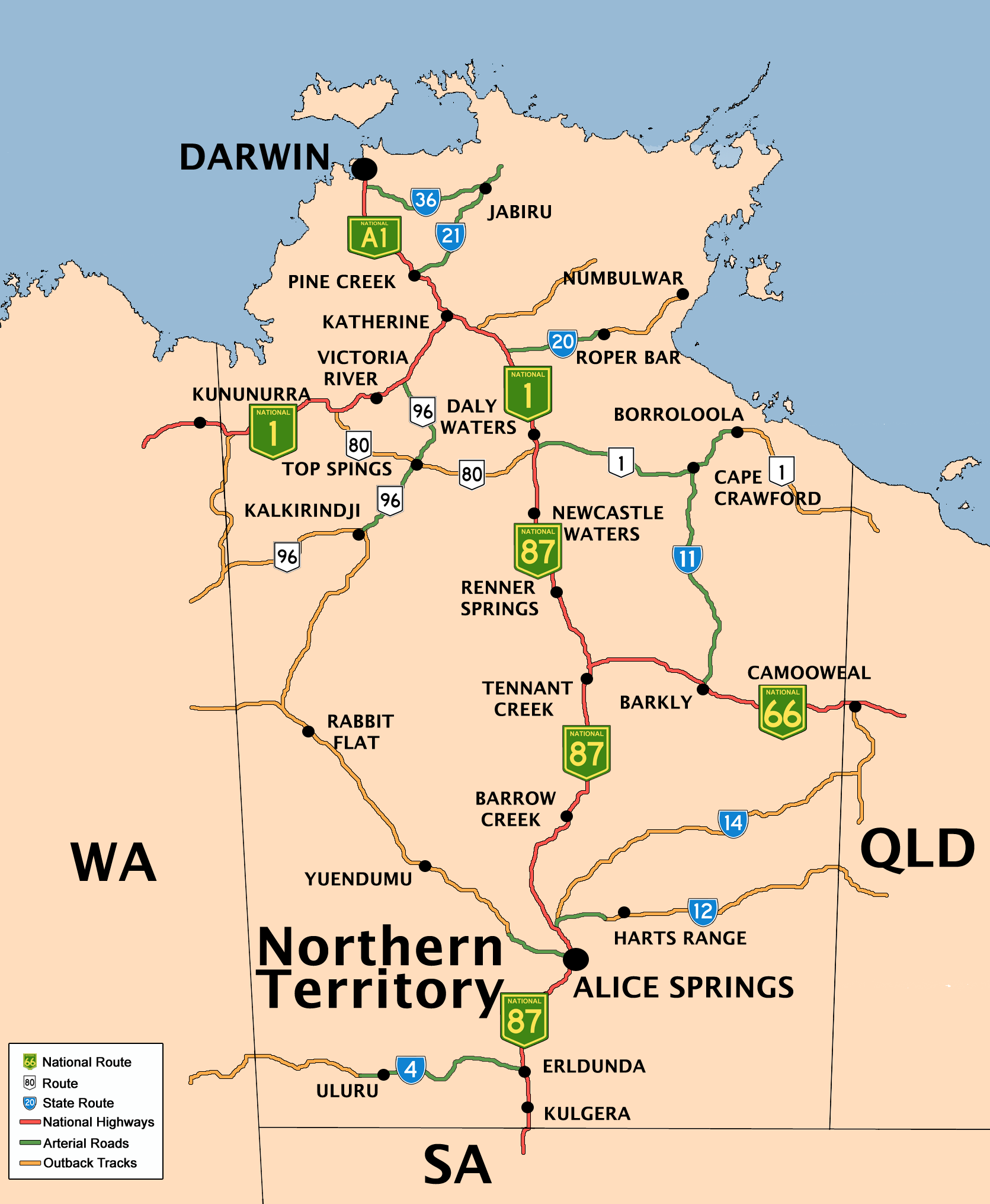
English: Created by Bidgee based upon on previous version by Mark and the previous version by Fikri. |
| दिनांक | ७ दिसम्बर २००४ (original upload date) |
| स्रोत | Transferred from en.wikipedia to Commons by Bidgee using CommonsHelper. |
| लेखक | इसका मूल अपलोड करने वाला अंग्रेज़ी विकिपीडिया पर Fikri है। |
लाइसेंस

|
इस दस्तावेज़ को Free Software Foundation द्वारा प्रकाशित GNU मुक्त प्रलेख लाइसेंस के संस्करण 1.2 या नए (बिना किसी अपरिवर्तनीय अनुभागों और अगले या पिछले आवरण के टेक्स्ट के) के अंतर्गत प्रतिलिपि बनाने, बाँटने और/या बदलने की अनुमति प्रदान की जाती है। इस लाइसेंस की एक प्रतिलिपि GNU मुक्त प्रलेख लाइसेंस नामक अनुभाग में शामिल है। Subject to disclaimers. |
मूल अपलोड लॉग
The original description page was here. All following user names refer to en.wikipedia.
- 2008-06-15 06:23 Bidgee 1671×2031×8 (387634 bytes) Reverted to version as of 06:06, 15 June 2008
- 2008-06-15 06:18 Rom rulz424 401×487×8 (114087 bytes) Reverted to version as of 05:51, 15 June 2008
- 2008-06-15 06:06 Bidgee 1671×2031×8 (387634 bytes) Fixed. Next time inform me of any changes so it can be done that way the high res image stays how it should be
- 2008-06-15 05:51 Rom rulz424 401×487×8 (114087 bytes) National Highway Route 87, terminates at Daly Waters, not Katherine as the previous map suggests. Route 1 is the only continuous route throughout Australia and can be proven that National Highway Route 1 turns off at Daly Waters along the Carpentaria High
- 2008-06-14 14:08 Bidgee 1671×2031×8 (382374 bytes) Fixed Routes 66 and 1. Darwin is A1
- 2008-06-14 13:14 Rom rulz424 493×599×8 (150852 bytes) Route 66 and 1 both required the "NATIONAL" shield. It may show on Google Maps that there are square with no alphanumeric symbol beside it, but no Australian route exists with a square and a number only inside in green. If you refer to other references l
- 2008-06-14 09:32 Bidgee 1671×2031×8 (360953 bytes) Update routes based on Google Maps
- 2008-05-19 15:40 Bidgee 1671×2031×8 (1793646 bytes) New version based on previous versions by Mark and Fikri.
- 2007-04-24 16:28 Mark 744×1052×8 (82741 bytes) New (beautified) version of the original map by [[User:Fikri]].
- 2004-12-10 10:19 Clarkk 760×1009×4 (18240 bytes) crop image
- 2004-12-07 09:35 Fikri 810×1080×4 (17298 bytes) {{GFDL}}
चित्र का इतिहास
फ़ाइलका पुराना अवतरण देखने के लिये दिनांक/समय पर क्लिक करें।
| दिनांक/समय | थंबनेल | आकार | सदस्य | प्रतिक्रिया | |
|---|---|---|---|---|---|
| वर्तमान | 13:21, 14 जुलाई 2008 | | 1,671 × 2,031 (379 KB) | Bidgee | {{Information |Description={{en|Created by Bidgee based upon on [http://upload.wikimedia.org/wikipedia/en/archive/3/32/20080519154026%21NTRoads.png previous version] by Mark and [http://upload.wikimedia.org/wikipedia/ |
चित्र का उपयोग
निम्नलिखित पन्ने इस चित्र से जुडते हैं :
चित्र का वैश्विक उपयोग
इस चित्र का उपयोग इन दूसरे विकियों में किया जाता है:
- de.wikipedia.org पर उपयोग
- de.wikivoyage.org पर उपयोग
- en.wikipedia.org पर उपयोग
- eo.wikipedia.org पर उपयोग
- fr.wikipedia.org पर उपयोग
- he.wikipedia.org पर उपयोग
- he.wikivoyage.org पर उपयोग
- it.wikipedia.org पर उपयोग
- ja.wikipedia.org पर उपयोग
- kn.wikipedia.org पर उपयोग
- pl.wikipedia.org पर उपयोग
- ru.wikipedia.org पर उपयोग
- simple.wikipedia.org पर उपयोग
- si.wikipedia.org पर उपयोग
- uz.wikipedia.org पर उपयोग
- vls.wikipedia.org पर उपयोग