
चित्र:NASA - Visible Earth, Lakes of the African Rift Valley.jpg

इस पूर्वावलोकन का आकार: 800 × 523 पिक्सेल। दूसरे रेसोल्यूशन्स: 320 × 209 पिक्सेल | 640 × 419 पिक्सेल | 1,000 × 654 पिक्सेल।
मूल चित्र ((1,000 × 654 पिक्सेल, फ़ाइल का आकार: 127 KB, MIME प्रकार: image/jpeg))
|
|
यह फ़ाइल विकिमेडिया कॉमन्स से है। वहाँ पर इसका विवरण पृष्ठ निम्नोक्त है। कॉमन्स मुक्त लाइसेंसों के अंतर्गत उपलब्ध मीडिया फ़ाइलों का संग्रह है। आप भी इसमें मदद कर सकते हैं। |
सारांश
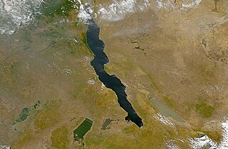
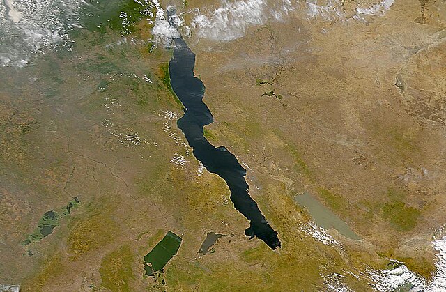
| विवरण | The lakes of the African Rift Valley exhibit wide variations in water color as can be seen in this SeaWiFS image. From left to right the lakes are: Lake Upembe, Lake Mweru, Lake Tanganyika (largest), and Lake Rukwa. This image spans the southeastern corner of the Democratic Republic of the Congo, northeastern Zambia, and southern Tanzania. |
| दिनांक | |
| स्रोत | http://visibleearth.nasa.gov/view_rec.php?id=757 |
| लेखक | SeaWiFS Project, NASA/Goddard Space Flight Center, and ORBIMAGE |
| This image appeared on English Wikipedia's Main Page in the Did you know? column on 26 March 2004 (see archives). |
लाइसेंस
| This image is from the Sea-viewing Wide Field-of-view Sensor (SeaWiFS) Project and more than 5 years old.
Satellite data captured by the SeaWIFS sensor are released into the public domain 5 years after capture. Data less than five years old can be re-used only for educational or scientific purposes; any commercial use of such images must be coordinated with GeoEye. [1] |
| This work has been released into the public domain by its copyright holder, GeoEye. This applies worldwide. कुछ देशों में यह कानूनी तौर पर नहीं हो सकता है; ऐसा हो तो: GeoEye सभी को इस कार्य का इस्तेमाल किसी भी उद्देश्य से, बिना किसी बाधाओं के इन शर्तों के कानून द्वारा अनिवार्य किए तक करने की अनुमति देता/देती हैं।
|
चित्र का इतिहास
फ़ाइलका पुराना अवतरण देखने के लिये दिनांक/समय पर क्लिक करें।
| दिनांक/समय | थंबनेल | आकार | सदस्य | प्रतिक्रिया | |
|---|---|---|---|---|---|
| वर्तमान | 18:40, 25 सितंबर 2005 | | 1,000 × 654 (127 KB) | Moyogo | from NASA [http://visibleearth.nasa.gov/view_rec.php?id=757] Category:Africa |
चित्र का उपयोग
निम्नलिखित पन्ने इस चित्र से जुडते हैं :
चित्र का वैश्विक उपयोग
इस चित्र का उपयोग इन दूसरे विकियों में किया जाता है:
- af.wikipedia.org पर उपयोग
- als.wikipedia.org पर उपयोग
- ar.wikipedia.org पर उपयोग
- ast.wiktionary.org पर उपयोग
- be.wikipedia.org पर उपयोग
- bh.wikipedia.org पर उपयोग
- ca.wikipedia.org पर उपयोग
- cs.wikipedia.org पर उपयोग
- de.wikipedia.org पर उपयोग
- de.wiktionary.org पर उपयोग
- en.wikipedia.org पर उपयोग
- eo.wikipedia.org पर उपयोग
- es.wikipedia.org पर उपयोग
- eu.wikipedia.org पर उपयोग
- fa.wikipedia.org पर उपयोग
- fi.wikipedia.org पर उपयोग
- fr.wikipedia.org पर उपयोग
- fr.wiktionary.org पर उपयोग
- ga.wikipedia.org पर उपयोग
- he.wikipedia.org पर उपयोग
- id.wikipedia.org पर उपयोग
- is.wikipedia.org पर उपयोग
- ka.wikipedia.org पर उपयोग
- ku.wikipedia.org पर उपयोग
- ky.wikipedia.org पर उपयोग
- ln.wikipedia.org पर उपयोग
- lv.wikipedia.org पर उपयोग
- mg.wikipedia.org पर उपयोग
- ms.wikipedia.org पर उपयोग
- nds.wikipedia.org पर उपयोग
- nl.wikipedia.org पर उपयोग
इस चित्र के वैश्विक उपयोग की अधिक जानकारी देखें।