
चित्र:Map indicating Amundsen Gulf, Northwest Territories, Canada.png
इससे बड़ा रेसोल्यूशन उपलब्ध नहीं हैं।
Map_indicating_Amundsen_Gulf,_Northwest_Territories,_Canada.png ((395 × 370 पिक्सेल, फ़ाइल का आकार: 60 KB, MIME प्रकार: image/png))
|
|
यह फ़ाइल विकिमेडिया कॉमन्स से है। वहाँ पर इसका विवरण पृष्ठ निम्नोक्त है। कॉमन्स मुक्त लाइसेंसों के अंतर्गत उपलब्ध मीडिया फ़ाइलों का संग्रह है। आप भी इसमें मदद कर सकते हैं। |
सारांश
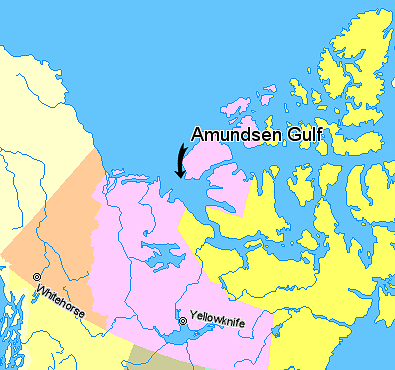
Map indicating Amundsen Gulf, Northwest Territories, Canada.
Nunavut
Northwest Territories
Yukon Territory
British Columbia
Alaska
© Her Majesty the Queen in Right of Canada, Department of Natural Resources. All rights reserved.
Licence Agreement
लाइसेंस

|
The copyright holder of this work allows anyone to use it for any purpose including unrestricted redistribution, commercial use, and modification.
Usage notes:
|
चित्र का इतिहास
फ़ाइलका पुराना अवतरण देखने के लिये दिनांक/समय पर क्लिक करें।
| दिनांक/समय | थंबनेल | आकार | सदस्य | प्रतिक्रिया | |
|---|---|---|---|---|---|
| वर्तमान | 01:42, 21 मार्च 2006 | | 395 × 370 (60 KB) | David Kernow~commonswiki | Map indicating Amundsen Gulf, Northwest Territories, Canada. {{legend|#ffff66|Nunavut}} {{legend|#ffccff|Northwest Territories}} {{legend|#ffcc99|Yukon Territory}} {{legend|#ffff99|British Columbia}} {{legend|#ffffcc|Alaska}} <br> © |
चित्र का उपयोग
निम्नलिखित पन्ने इस चित्र से जुडते हैं :
चित्र का वैश्विक उपयोग
इस चित्र का उपयोग इन दूसरे विकियों में किया जाता है:
- af.wikipedia.org पर उपयोग
- az.wikipedia.org पर उपयोग
- bg.wikipedia.org पर उपयोग
- bn.wikipedia.org पर उपयोग
- bs.wikipedia.org पर उपयोग
- cs.wikipedia.org पर उपयोग
- de.wikipedia.org पर उपयोग
- en.wikipedia.org पर उपयोग
- eo.wikipedia.org पर उपयोग
- es.wikipedia.org पर उपयोग
- et.wikipedia.org पर उपयोग
- eu.wikipedia.org पर उपयोग
- fa.wikipedia.org पर उपयोग
- fr.wikipedia.org पर उपयोग
- fy.wikipedia.org पर उपयोग
- ilo.wikipedia.org पर उपयोग
- it.wikipedia.org पर उपयोग
- ja.wikipedia.org पर उपयोग
- ka.wikipedia.org पर उपयोग
- ko.wikipedia.org पर उपयोग
- ku.wikipedia.org पर उपयोग
- la.wikipedia.org पर उपयोग
- lt.wikipedia.org पर उपयोग
- mk.wikipedia.org पर उपयोग
- nl.wikipedia.org पर उपयोग
- nn.wikipedia.org पर उपयोग
- pa.wikipedia.org पर उपयोग
- pl.wikipedia.org पर उपयोग
- pl.wiktionary.org पर उपयोग
- pnb.wikipedia.org पर उपयोग
- sh.wikipedia.org पर उपयोग
- sl.wikipedia.org पर उपयोग
- sr.wikipedia.org पर उपयोग
- tr.wikipedia.org पर उपयोग
- uk.wikipedia.org पर उपयोग
- ur.wikipedia.org पर उपयोग
- vi.wikipedia.org पर उपयोग
- war.wikipedia.org पर उपयोग
- xmf.wikipedia.org पर उपयोग
- zh-min-nan.wikipedia.org पर उपयोग
- zh.wikipedia.org पर उपयोग