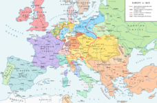
चित्र:Map congress of vienna.jpg
Map_congress_of_vienna.jpg ((767 × 594 पिक्सेल, फ़ाइल का आकार: 325 KB, MIME प्रकार: image/jpeg))
चित्र का इतिहास
फ़ाइलका पुराना अवतरण देखने के लिये दिनांक/समय पर क्लिक करें।
| दिनांक/समय | थंबनेल | आकार | सदस्य | प्रतिक्रिया | |
|---|---|---|---|---|---|
| वर्तमान | 00:24, 3 दिसम्बर 2015 |  | 767 × 594 (325 KB) | Ras67 | cropped |
| 17:34, 29 नवम्बर 2015 |  | 775 × 600 (296 KB) | Spiridon Ion Cepleanu | Add today 2015, nov.29 some details & corrections in the Austrian & Ottoman empires, according with « Grosser Atlas zur Weltgeschichte » (H.E.Stier, dir.) Westermann 1985, ISBN 3-14-100919-8, « Putzger historischer Weltatlas Cornelsen » 1990, ISBN... | |
| 16:58, 3 अप्रैल 2013 |  | 775 × 600 (96 KB) | Lubiesque | Map corrected. Luxembourg was part of the German Confederation. | |
| 17:48, 20 नवम्बर 2010 |  | 1,292 × 1,000 (356 KB) | P. S. Burton | {{Information |Description=Map of Europe, after the Congress of Vienna, 1815 |Source=[http://www.nobility-association.com/thecongressofvienna.htm The International Commission and Association on Nobility] |Date=2009 |Author=The International Commission and |
चित्र का उपयोग
निम्नलिखित पन्ने इस चित्र से जुडते हैं :
चित्र का वैश्विक उपयोग
इस चित्र का उपयोग इन दूसरे विकियों में किया जाता है:
- ar.wikipedia.org पर उपयोग
- az.wikipedia.org पर उपयोग
- ca.wikipedia.org पर उपयोग
- cs.wikipedia.org पर उपयोग
- da.wikipedia.org पर उपयोग
- en.wikipedia.org पर उपयोग
- en.wikibooks.org पर उपयोग
- eo.wikipedia.org पर उपयोग
- es.wikipedia.org पर उपयोग
- et.wikipedia.org पर उपयोग
- fi.wikipedia.org पर उपयोग
- fr.wikipedia.org पर उपयोग
- hy.wikipedia.org पर उपयोग
- id.wikipedia.org पर उपयोग
- io.wikipedia.org पर उपयोग
- it.wikipedia.org पर उपयोग
- ja.wikipedia.org पर उपयोग
- ka.wikipedia.org पर उपयोग
- lv.wikipedia.org पर उपयोग
- ms.wikipedia.org पर उपयोग
- pl.wikipedia.org पर उपयोग
- ro.wikipedia.org पर उपयोग
- ru.wikipedia.org पर उपयोग
- sco.wikipedia.org पर उपयोग
- sh.wikipedia.org पर उपयोग
- sv.wikipedia.org पर उपयोग
- tr.wikipedia.org पर उपयोग
- uk.wikipedia.org पर उपयोग
- ur.wikipedia.org पर उपयोग


