
चित्र:Map India and Pakistan 1-250,000 Tile NI 44-9 Pangong Tso.jpg

इस पूर्वावलोकन का आकार: 790 × 599 पिक्सेल। दूसरे रेसोल्यूशन्स: 317 × 240 पिक्सेल | 633 × 480 पिक्सेल | 1,013 × 768 पिक्सेल | 1,280 × 971 पिक्सेल | 2,560 × 1,942 पिक्सेल | 5,000 × 3,793 पिक्सेल।
मूल चित्र ((5,000 × 3,793 पिक्सेल, फ़ाइल का आकार: 3.81 MB, MIME प्रकार: image/jpeg))
|
|
यह फ़ाइल विकिमेडिया कॉमन्स से है। वहाँ पर इसका विवरण पृष्ठ निम्नोक्त है। कॉमन्स मुक्त लाइसेंसों के अंतर्गत उपलब्ध मीडिया फ़ाइलों का संग्रह है। आप भी इसमें मदद कर सकते हैं। |
सारांश
| Description |
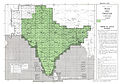
English: NI 44-9 Pangong Tso. Tile of the Map India and Pakistan 1:250,000. Series U502, U.S. Army Map Service, 1955 |
|||||||||
| दिनांक |
Compiled: 1954 Revised: 1962 Printed: January 1963 |
|||||||||
| स्रोत | Courtesy of the University of Texas Libraries, The University of Texas at Austin. ([1]) | |||||||||
| रचियता |
English: U.S. Army Map Service |
|||||||||
| Geotemporal data | ||||||||||
| Bounding box |
|
|||||||||
| Georeferencing | ||||||||||
| दूसरे संस्करण |
|
|||||||||


-
 Index Map

![[1]](http://www.lib.utexas.edu/maps/ams/india/ni-44-09.jpg)
लाइसेंस
This image or file is a work of a U.S. Army Corps of Engineers soldier or employee, taken or made as part of that person's official duties. As a work of the U.S. federal government, the image is in the public domain.
|
चित्र का इतिहास
फ़ाइलका पुराना अवतरण देखने के लिये दिनांक/समय पर क्लिक करें।
| दिनांक/समय | थंबनेल | आकार | सदस्य | प्रतिक्रिया | |
|---|---|---|---|---|---|
| वर्तमान | 19:09, 11 सितंबर 2012 | | 5,000 × 3,793 (3.81 MB) | Slick-o-bot | {{Information |Description={{en|1=NI 44-9 Pangong Tso. Tile of the Map India and Pakistan 1:250,000. Series U502, U.S. Army Map Service, 1955}} |Source=https://www.lib.utexas.edu/maps/ams/india/ [http://www.lib.utexas.edu/maps/ams/india/ni-44-09.jpg] |... |
चित्र का उपयोग
निम्नलिखित पन्ने इस चित्र से जुडते हैं :
चित्र का वैश्विक उपयोग
इस चित्र का उपयोग इन दूसरे विकियों में किया जाता है:
- bn.wikipedia.org पर उपयोग
- en.wikipedia.org पर उपयोग
- mai.wikipedia.org पर उपयोग
- ne.wikipedia.org पर उपयोग