
चित्र:Map German World.png

इस पूर्वावलोकन का आकार: 800 × 372 पिक्सेल। दूसरे रेसोल्यूशन्स: 320 × 149 पिक्सेल | 640 × 297 पिक्सेल | 1,337 × 621 पिक्सेल।
मूल चित्र ((1,337 × 621 पिक्सेल, फ़ाइल का आकार: 240 KB, MIME प्रकार: image/png))
|
|
यह फ़ाइल विकिमेडिया कॉमन्स से है। वहाँ पर इसका विवरण पृष्ठ निम्नोक्त है। कॉमन्स मुक्त लाइसेंसों के अंतर्गत उपलब्ध मीडिया फ़ाइलों का संग्रह है। आप भी इसमें मदद कर सकते हैं। |

|
File:Legal statuses of German in the world.svg is a vector version of this file. It should be used in place of this PNG file when not inferior.
File:Map German World.png → File:Legal statuses of German in the world.svg
For more information, see Help:SVG. |
 |
| विवरण |
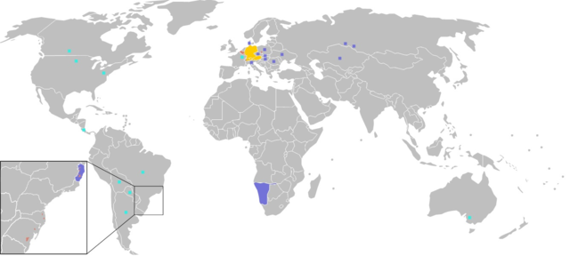
Čeština: Legenda:
původní jazyk
druhý nebo neoficiální jazyk
německá menšina Deutsch: Legende:
Amtssprache/Muttersprache
Zweitsprache, „Nationalsprache“ oder nicht offizielle Amtssprache.
Deutsche Minderheiten English: Legend:
native language
Secondary language "national language" or non-official.
German minorities Suomi: Värien merkitys:
äidinkieli
toinen tai ei-virallinen kieli
saksankielisiä vähemmistöjä Français : Carte du monde où on parle l'allemand.
langue maternelle
langue importante, "langue nationale" et/ou langue de culture
minorités allemandes עברית:
Italiano: Legenda:
lingua materna
seconda lingua o lingua non ufficiale
minoranze tedesche Lëtzebuergesch: Legend:
Amtssprooch/Mammesprooch
Zweetsprooch, „Nationalsprooch“ oder net offiziell Amtssprooch
Däitsch Mannerheeten Polski: Legenda:
Język urzędowy/Język ojczysty
Drugi język ojczysty albo nieoficjalny język urzędowy.
Mniejszości Niemieckie Português: Legenda:
língua mãe
língua importante, "língua nacional" e/ou língua de cultura
minorias alemãs Română: Legendă:
limbă maternă naţională
limbă secundară, „limbă națională” sau neoficială
minorități germane Русский: Легенда:
Государственный/Родной язык.
Второй или неофициальный государственный язык.
Немецкие национальные меньшинства Українська: Легенда:
Рідна мова.
Другорядна "національна мова" або неофіційна.
Німецькі меншини |
||
| स्रोत | Image:BlankMap-World.png | ||
| लेखक | User:Ilario | ||
| अनुमति (इस चित्र का पुनः उपयोग करना) |
|
||
| दूसरे संस्करण | File is obsolete! Use File:Legal statuses of German in the world.svg instead. |
चित्र का इतिहास
फ़ाइलका पुराना अवतरण देखने के लिये दिनांक/समय पर क्लिक करें।
| दिनांक/समय | थंबनेल | आकार | सदस्य | प्रतिक्रिया | |
|---|---|---|---|---|---|
| वर्तमान | 21:59, 19 सितंबर 2016 | | 1,337 × 621 (240 KB) | Alatab | I added a square in northern Costa Rica, because there is one of the most important and biggest German speakers communities in Central America and the Caribbean. Also the German is one of the most used foreign languages in the country. |
| 01:08, 15 सितंबर 2014 |  | 1,357 × 628 (35 KB) | Leftcry | Border fix | |
| 00:44, 17 फ़रवरी 2009 |  | 1,357 × 628 (24 KB) | Disposable.Heroes | pngcrush | |
| 13:17, 30 सितंबर 2006 |  | 1,357 × 628 (53 KB) | Huhsunqu | Pozuzo | |
| 14:24, 26 जून 2006 |  | 1,357 × 628 (53 KB) | Roke~commonswiki | talk page comment to include Alemán Coloniero in venezuela | |
| 11:29, 18 जनवरी 2006 |  | 1,357 × 628 (30 KB) | Ilario | Map made from Image:BlankMap-World.png {{PD-user|Yug}} {{en|Legend: *Dark Orange: native language *Light orange: Secondary language or non-official. *Orange square: German minorities}} {{fr|Carte du monde où on parle l'italien. *Orange foncé: lan |
चित्र का उपयोग
इस चित्र से कोई पन्ने नहीं जुड़ते
चित्र का वैश्विक उपयोग
इस चित्र का उपयोग इन दूसरे विकियों में किया जाता है:
- cy.wikipedia.org पर उपयोग
- en.wikipedia.org पर उपयोग
- fr.wikipedia.org पर उपयोग
- it.wikipedia.org पर उपयोग