
चित्र:Madhhab Map2.png
इस पूर्वावलोकन का आकार: 800 × 388 पिक्सेल। दूसरे रेसोल्यूशन्स: 320 × 155 पिक्सेल | 640 × 310 पिक्सेल | 1,245 × 604 पिक्सेल।
मूल चित्र ((1,245 × 604 पिक्सेल, फ़ाइल का आकार: 50 KB, MIME प्रकार: image/png))
|
|
यह फ़ाइल विकिमेडिया कॉमन्स से है। वहाँ पर इसका विवरण पृष्ठ निम्नोक्त है। कॉमन्स मुक्त लाइसेंसों के अंतर्गत उपलब्ध मीडिया फ़ाइलों का संग्रह है। आप भी इसमें मदद कर सकते हैं। |

|
This religion map image could be re-created using vector graphics as an SVG file. This has several advantages; see Commons:Media for cleanup for more information. If an SVG form of this image is available, please upload it and afterwards replace this template with
{{vector version available|new image name}}.
It is recommended to name the SVG file “Madhhab Map2.svg”—then the template Vector version available (or Vva) does not need the new image name parameter. |
सारांश
| विवरण |
العربية: المدارس الفقهية الإسلامية الرئيسيّة وانتشارها حول العالم (لغة إنجليزية)
فارسی: نقشهٔ پراکندگی مذاهب فقهی اسلام در جهان (انگلیسی)
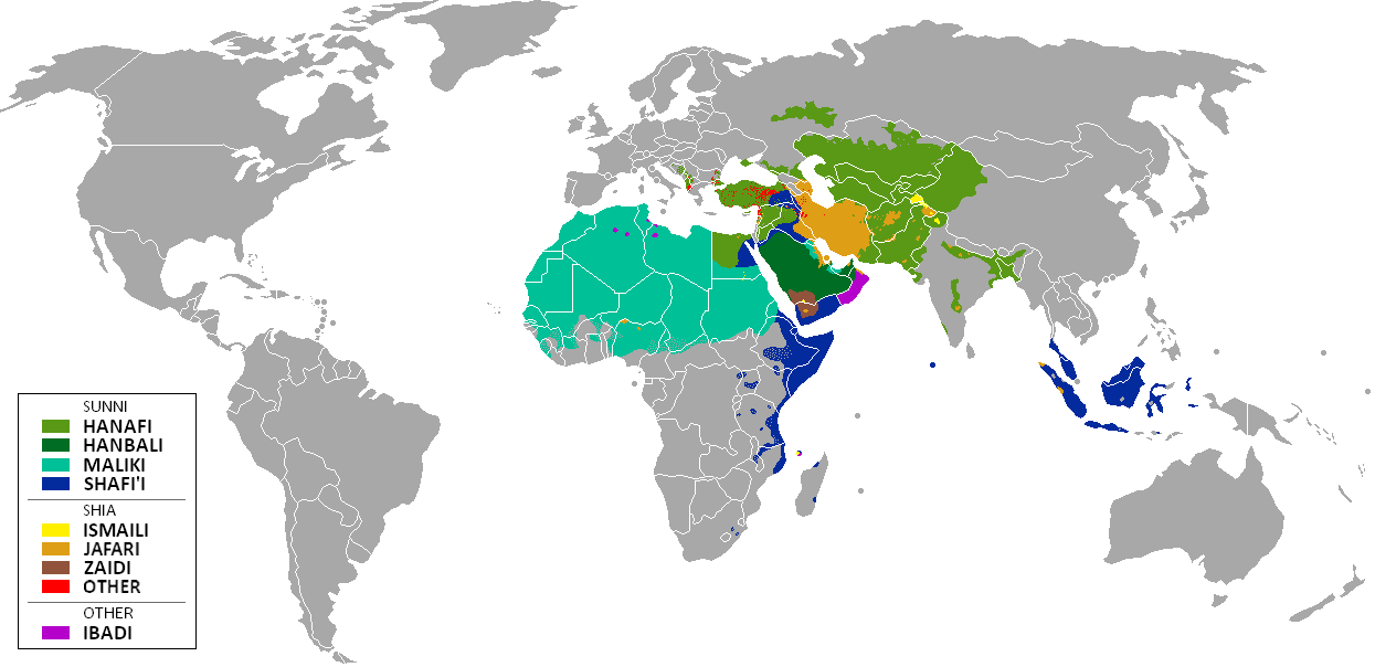
English: The distribution of the predominant Islamic madhhab (school of law) followed in majority-Muslim countries and regions (English)
Bahasa Indonesia: Distribusi penyebaran agama islam berdasarkan Mahdab di negara-negara dan wilayah dunia |
| दिनांक | |
| स्रोत | Own work by uploader from a blank-map, based on this source: Legal Sources and various other sources |
| लेखक | Ghibar |
| दूसरे संस्करण |
Derivative works of this file: |
लाइसेंस
मैं, इस कार्य का/की कॉपीराइट धारक, इसे निम्न लाइसेंसों के अंतर्गत प्रकाशित करता/करती हूँ:
इस फ़ाइल को क्रिएटिव कॉमन्स श्रेय-समानसांझा 3.0 अनरिपोर्टेड लाइसेंस के अंतर्गत लाइसेंस किया गया है।
- आप खुलकर:
- बाँट सकते हैं – रचना की प्रतिलिपि बना सकते हैं, बाँँट सकते हैं और संचारित कर सकते हैं
- रीमिक्स कर सकते हैं – कार्य को अनुकूलित कर सकते हैं
- निम्नलिखित शर्तों के अंतर्गत:
- श्रेय – यह अनिवार्य है कि आप यथोचित श्रेय प्रदान करें, लाइसेंस की कड़ी प्रदान करें, और अगर कोई बदलाव हुए हों तो उन्हें इंगित करें। आप ऐसा किसी भी उचित तरीके से कर सकते हैं, लेकिन किसी भी तरह उससे यह नहीं संकेत नहीं किया जाना चाहिए कि लाइसेंसधारी द्वारा आपको अथवा आपके इस प्रयोग का समर्थन किया जा रहा हो।
- समानसांझा – अगर आप इस रचना में कोई बदलाव करते हैं या इसपर आधारित कुछ रचित करते हैं तो आप अपने योगदान को सिर्फ इसी या इसके सामान किसी लाइसेंस के अंतर्गत बाँट सकते हैं।

|
इस दस्तावेज़ को Free Software Foundation द्वारा प्रकाशित GNU मुक्त प्रलेख लाइसेंस के संस्करण 1.2 या नए (बिना किसी अपरिवर्तनीय अनुभागों और अगले या पिछले आवरण के टेक्स्ट के) के अंतर्गत प्रतिलिपि बनाने, बाँटने और/या बदलने की अनुमति प्रदान की जाती है। इस लाइसेंस की एक प्रतिलिपि GNU मुक्त प्रलेख लाइसेंस नामक अनुभाग में शामिल है। |
आप अपना पसंद का लाइसेंस चुन सकते हैं।
| Annotations | This image is annotated: View the annotations at Commons |
चित्र का इतिहास
फ़ाइलका पुराना अवतरण देखने के लिये दिनांक/समय पर क्लिक करें।
| दिनांक/समय | थंबनेल | आकार | सदस्य | प्रतिक्रिया | |
|---|---|---|---|---|---|
| वर्तमान | 11:24, 23 जनवरी 2018 | | 1,245 × 604 (50 KB) | Maphobbyist | Revert. Jafari school more widespread in northern Sumatra according to sources, than mere dots. |
| 11:55, 30 मई 2016 |  | 1,245 × 604 (2.87 MB) | Riyantojayadi | Madhhab majority of Aceh region[1] and West Sumatra/Minangkabau region[2] in Indonesia are Syafii school of Sunni. There are some tribe's ritual in this area that are based on Shia such tabot, however, for religion, they are practicing . Shia communiti... | |
| 13:45, 11 जनवरी 2015 |  | 1,245 × 604 (50 KB) | AnonMoos | Reverted to version as of 02:11, 30 July 2014 -- see User_talk:Peaceworld111 | |
| 10:24, 11 जनवरी 2015 |  | 1,245 × 604 (52 KB) | Peaceworld111 | Re-added Ahmadi. It's a sect of Islam per reliable sources and is not a mere dot. See talk page. | |
| 02:10, 11 जनवरी 2015 |  | 1,245 × 604 (50 KB) | AnonMoos | Reverted to version as of 02:11, 30 July 2014 -- change not discussed on image talk page, possibly problematic, see user talk page | |
| 18:11, 8 जनवरी 2015 |  | 1,245 × 604 (52 KB) | Peaceworld111 | Added Ahmadi | |
| 02:11, 30 जुलाई 2014 |  | 1,245 × 604 (50 KB) | KronosLine | Fixed Russia | |
| 18:36, 20 जुलाई 2014 |  | 1,245 × 604 (63 KB) | Calthinus | distribution of Bektashis in Albania fixed, distribution of Muslims in Greece & Macedonia (esp the ethnic Slav Macedonian Muslims, whose distribution had previously not been marked) fixed, various other fixes... | |
| 17:50, 19 अक्टूबर 2013 |  | 1,245 × 604 (50 KB) | Hibernian | Damn it, that revert button doesn't do what I thought it does. Here's what I meant to change it to. This version also changes the Kerala Muslims to Shafi'i as was suggested on the talk page. | |
| 17:37, 19 अक्टूबर 2013 |  | 1,245 × 604 (55 KB) | Hibernian | Reverted to previous version. It is totally illogical to not show the borders of states with limited recognition (practically every map on Wikipedia depicts these entities), it has nothing to do with the official UN definitions, but with showing reality. |
चित्र का उपयोग
इस चित्र से कोई पन्ने नहीं जुड़ते
चित्र का वैश्विक उपयोग
इस चित्र का उपयोग इन दूसरे विकियों में किया जाता है:
- bn.wikipedia.org पर उपयोग
- bn.wikivoyage.org पर उपयोग
- en.wikipedia.org पर उपयोग
- en.wikivoyage.org पर उपयोग
- he.wikipedia.org पर उपयोग
- hi.wikivoyage.org पर उपयोग
- id.wikipedia.org पर उपयोग
- incubator.wikimedia.org पर उपयोग
- it.wikivoyage.org पर उपयोग
- ja.wikipedia.org पर उपयोग
- mzn.wikipedia.org पर उपयोग
- uk.wikipedia.org पर उपयोग