
चित्र:Lunae Palus map.JPG
इससे बड़ा रेसोल्यूशन उपलब्ध नहीं हैं।
Lunae_Palus_map.JPG ((638 × 427 पिक्सेल, फ़ाइल का आकार: 47 KB, MIME प्रकार: image/jpeg))
|
|
यह फ़ाइल विकिमेडिया कॉमन्स से है। वहाँ पर इसका विवरण पृष्ठ निम्नोक्त है। कॉमन्स मुक्त लाइसेंसों के अंतर्गत उपलब्ध मीडिया फ़ाइलों का संग्रह है। आप भी इसमें मदद कर सकते हैं। |
सारांश
| विवरण |
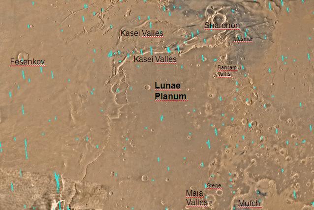
English: Map of Lunae Palus quadrangle with labels. The small, colored rectangles represent image footprints for the narrow angle camera on the Mars Global Surveyor. Some are about 1 mile wide, the otheers are about 2 miles wide. Português: Mapa do quadrângulo de Lunae Plus, em Marte |
| दिनांक | |
| स्रोत | http://www.msss.com/moc_gallery/s05_s10/mc10.html |
| लेखक | The map was made by the U.S. Geological survey for NASA. Jim Secosky (Jimmarsmars at en.wikipedia) modified. |
लाइसेंस
| This file is in the public domain in the United States because it was solely created by NASA. NASA copyright policy states that "NASA material is not protected by copyright unless noted". (See Template:PD-USGov, NASA copyright policy page or JPL Image Use Policy.) | ||
 |
Warnings:
|
मूल अपलोड लॉग
The original description page was here. All following user names refer to en.wikipedia.
- 2008-12-29 19:57 Jimmarsmars 638×427× (48204 bytes) {{Information |Description=Map of Lunae Palus map with labels |Source=http://www.msss.com/moc_gallery/s05_s10/mc10.html |Date=December 29, 2008 |Author=Jim Secosky modified NASA map. |Permission= |other_versions= }}
चित्र का इतिहास
फ़ाइलका पुराना अवतरण देखने के लिये दिनांक/समय पर क्लिक करें।
| दिनांक/समय | थंबनेल | आकार | सदस्य | प्रतिक्रिया | |
|---|---|---|---|---|---|
| वर्तमान | 14:52, 21 जनवरी 2011 | | 638 × 427 (47 KB) | Romullo | {{Information |Description= Mapa do quadrângulo de Lunae Plus, em Marte |Source= Wiki:en |Date=21/01/11 |Author=NASA |Permission= |other_versions=http://upload.wikimedia.org/wikipedia/en/2/29/Lunae_Palus_map.JPG }} |
चित्र का उपयोग
निम्नलिखित पन्ने इस चित्र से जुडते हैं :
चित्र का वैश्विक उपयोग
इस चित्र का उपयोग इन दूसरे विकियों में किया जाता है:
- en.wikipedia.org पर उपयोग
- es.wikipedia.org पर उपयोग
- ja.wikipedia.org पर उपयोग
- ml.wikipedia.org पर उपयोग
- pt.wikipedia.org पर उपयोग
- ru.wikipedia.org पर उपयोग
- tr.wikipedia.org पर उपयोग
- uk.wikipedia.org पर उपयोग
- zh.wikipedia.org पर उपयोग