
चित्र:Kara Sea map.png
इस पूर्वावलोकन का आकार: 658 × 599 पिक्सेल। दूसरे रेसोल्यूशन्स: 264 × 240 पिक्सेल | 527 × 480 पिक्सेल | 942 × 858 पिक्सेल।
मूल चित्र ((942 × 858 पिक्सेल, फ़ाइल का आकार: 258 KB, MIME प्रकार: image/png))
|
|
यह फ़ाइल विकिमेडिया कॉमन्स से है। वहाँ पर इसका विवरण पृष्ठ निम्नोक्त है। कॉमन्स मुक्त लाइसेंसों के अंतर्गत उपलब्ध मीडिया फ़ाइलों का संग्रह है। आप भी इसमें मदद कर सकते हैं। |

|
This locator map image could be re-created using vector graphics as an SVG file. This has several advantages; see Commons:Media for cleanup for more information. If an SVG form of this image is available, please upload it and afterwards replace this template with
{{vector version available|new image name}}.
It is recommended to name the SVG file “Kara Sea map.svg”—then the template Vector version available (or Vva) does not need the new image name parameter. |
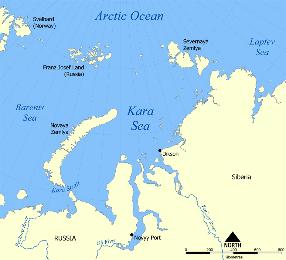
This map shows the location of the Kara Sea north of Russia. The sea is located south of the Arctic Ocean, east of the Barents Sea, west of the Laptev Sea, and is bounded by the Severnaya Zemlya and Novaya Zemlya.
Created by NormanEinstein, November 29, 2005.
मैं, इस कार्य का/की कॉपीराइट धारक, इसे निम्न लाइसेंसों के अंतर्गत प्रकाशित करता/करती हूँ:

|
इस दस्तावेज़ को Free Software Foundation द्वारा प्रकाशित GNU मुक्त प्रलेख लाइसेंस के संस्करण 1.2 या नए (बिना किसी अपरिवर्तनीय अनुभागों और अगले या पिछले आवरण के टेक्स्ट के) के अंतर्गत प्रतिलिपि बनाने, बाँटने और/या बदलने की अनुमति प्रदान की जाती है। इस लाइसेंस की एक प्रतिलिपि GNU मुक्त प्रलेख लाइसेंस नामक अनुभाग में शामिल है। |
| इस फ़ाइल को क्रिएटिव कॉमन्स श्रेय-समानसांझा 3.0 अनरिपोर्टेड लाइसेंस के अंतर्गत लाइसेंस किया गया है। | ||
| ||
| This licensing tag was added to this file as part of the GFDL licensing update. |
आप अपना पसंद का लाइसेंस चुन सकते हैं।
derivative works
Derivative works of this file:
चित्र का इतिहास
फ़ाइलका पुराना अवतरण देखने के लिये दिनांक/समय पर क्लिक करें।
| दिनांक/समय | थंबनेल | आकार | सदस्य | प्रतिक्रिया | |
|---|---|---|---|---|---|
| वर्तमान | 20:26, 14 जुलाई 2012 | | 942 × 858 (258 KB) | Ras67 | cropped, opt. |
| 22:12, 29 नवम्बर 2005 |  | 952 × 868 (382 KB) | NormanEinstein | This map shows the location of the Kara Sea north of Russia. The sea is located south of the Arctic Ocean, east of the Barents Sea, west of the Laptev Sea, and is bounded by the Severnaya Zemlya and Novaya Zemlya. Created by NormanEinstein, November 29, |
चित्र का उपयोग
निम्नलिखित पन्ने इस चित्र से जुडते हैं :
चित्र का वैश्विक उपयोग
इस चित्र का उपयोग इन दूसरे विकियों में किया जाता है:
- af.wikipedia.org पर उपयोग
- an.wikipedia.org पर उपयोग
- ar.wikipedia.org पर उपयोग
- avk.wikipedia.org पर उपयोग
- azb.wikipedia.org पर उपयोग
- az.wikipedia.org पर उपयोग
- bcl.wikipedia.org पर उपयोग
- be.wikipedia.org पर उपयोग
- bg.wikipedia.org पर उपयोग
- bn.wikipedia.org पर उपयोग
- br.wikipedia.org पर उपयोग
- bs.wikipedia.org पर उपयोग
- ca.wikipedia.org पर उपयोग
- cs.wikipedia.org पर उपयोग
- cy.wikipedia.org पर उपयोग
- da.wikipedia.org पर उपयोग
- de.wikipedia.org पर उपयोग
- en.wikipedia.org पर उपयोग
- en.wiktionary.org पर उपयोग
- eo.wikipedia.org पर उपयोग
- es.wikipedia.org पर उपयोग
- eu.wikipedia.org पर उपयोग
- fa.wikipedia.org पर उपयोग
- fi.wikipedia.org पर उपयोग
- frr.wikipedia.org पर उपयोग
- fr.wikipedia.org पर उपयोग
इस चित्र के वैश्विक उपयोग की अधिक जानकारी देखें।