
चित्र:Isla Tapu, Phuket, Tailandia, 2013-08-20, DD 36.JPG

मूल चित्र ((4,976 × 3,271 पिक्सेल, फ़ाइल का आकार: 6.03 MB, MIME प्रकार: image/jpeg))
|
|
यह फ़ाइल विकिमेडिया कॉमन्स से है। वहाँ पर इसका विवरण पृष्ठ निम्नोक्त है। कॉमन्स मुक्त लाइसेंसों के अंतर्गत उपलब्ध मीडिया फ़ाइलों का संग्रह है। आप भी इसमें मदद कर सकते हैं। |
|
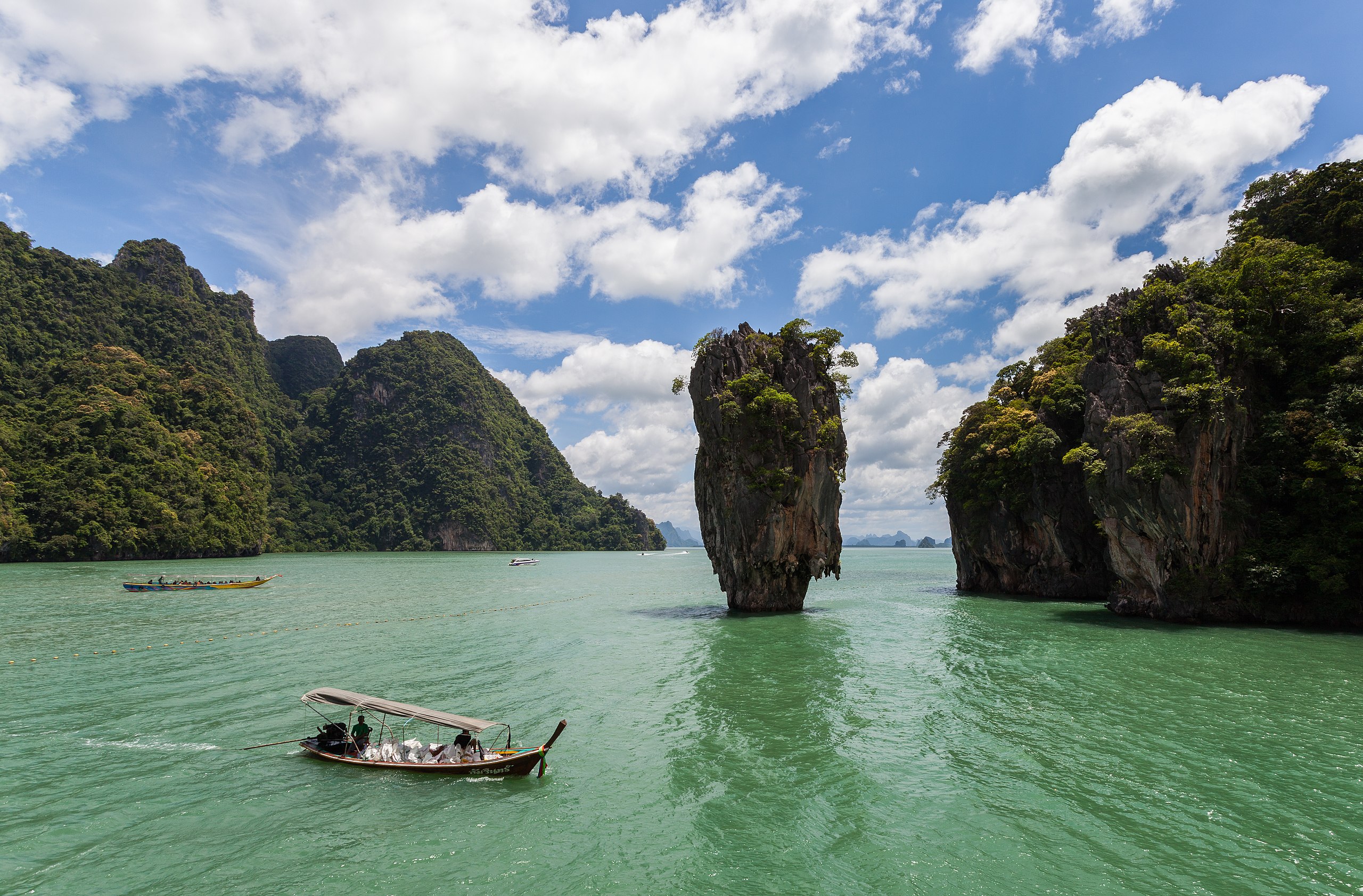
इस चित्र को विकिमीडिया कॉमन्स पर २८ जून २०१४ के लिए दैनिक प्रदर्शित चित्र के रूप में चुना गया था। इसका कैप्शन था: English: Ko Tapu is a 20 m tall islet in front of the Khao Phing Kan islands, in the Phang Nga Bay, in Thailand. The island belongs to the Ao Phang Nga National Park and since 1974 is also known as James Bond Island, because the James Bond movie The Man with the Golden Gun was filmed there. दूसरी भाषाएँ:
Bosanski: Ko Tapu je dvadeset metara visoka stijena u blizini obale ostrva Khao Phing Kan u zalivu Phang Nga, Tajland. Ostrvo pripada Nacionalnom parku Ao Phang Nga a od 1974. godine je poznato i kao ostrvo Jamesa Bonda, jer se tamo snimao film o James Bondu Čovjek sa zlatnim pištoljem. Čeština: Ko Tapu je asi 20 m vysoký ostrůvek před párem ostrovů Khao Phing Kan, v zálivu Phang Nga, Thajsko. Ostrov je součástí národního parku Ao Phang Nga a od roku 1974 je také znám jako Ostrov Jamese Bonda, protože se zde natáčela filmová bondovka Muž se zlatou zbraní. English: Ko Tapu is a 20 m tall islet in front of the Khao Phing Kan islands, in the Phang Nga Bay, in Thailand. The island belongs to the Ao Phang Nga National Park and since 1974 is also known as James Bond Island, because the James Bond movie The Man with the Golden Gun was filmed there. Español: Ko Tapu es un pequeño islote de 20 m de altura frente a las islas Khao Phing Kan, en la bahía de Phang Nga Bay, en Tailandia. La isla pertenece al parque Nacional Phang Nga y se le conoce desde 1974 como la Isla de James Bond, porque la película de James Bond The Man with the Golde Gun se filmó allí. Français : L'îlot de Ko Tapu, haut de 20m, fait face aux îles Khao Phing Kan, dans la Baie de Phang Nga, en Thaïlande. Ces îles appartiennent au Parc national d'Ao Phang Nga. Depuis 1974, ce lieu est appelé James Bond Island, à cause du film L'Homme au pistolet d'or, qui y fut tourné. Italiano: Ko Tapu è un'isoletta alta 20 m di fronte alle isole di Khao Phing Kan in Tailandia, resa famosa dal film di James Bond Agente 007 - L'uomo dalla pistola d'oro. Magyar: Ko Tapu; egy 20 m magas sziget a Khao Phing Kan szigetek előtt a Phangnga-öbölben, Thaiföldön. A sziget az Au Phangnga Nemzeti Parkhoz tartozik és 1974 óta James Bond-szigetként is ismert, mert itt forgatták Az aranypisztolyos férfi című filmet Nederlands: Ko Tapu is een 20 meter hoge kalksteenrots voor het eiland Khao Phing Kan, in de Baai van Phang Nga, in Thailand. De rots en het eiland behoren tot het Nationaal Park Ao Phang Nga en zijn sinds 1974 ook bekend als James Bond-Eiland vanwege de James Bond-film The Man with the Golden Gun die hier opgenomen is. 한국어: 코 타푸는 태국 팡아만의 핑칸 섬 앞에 놓여 있는 20 m 높이의 작은 섬이다. 이 섬은 아오 팡아 국립공원에 속하며, 이곳에서 007 시리즈인 영화 《황금총을 가진 사나이》를 여기에서 촬영했기에 1974년 이후로 ‘제임스 본드 섬’으로도 알려지기도 했다. |
This image was selected as picture of the day on Vietnamese Wikipedia.
|
सारांश
| विवरण |
Español: Ko Tapu (Isla Tapu) es un islote e 20 metros de altura situado frente a las islas Kho Phin Kan, en la Bahía de Phang Nga, Tailandia. El islote pertenece al Parque Nacional de Phang Nga y es conocido como La Isla de James Bond desde 1974, fecha en la que se estrenó la película El hombre de la pistola de oro, que se filmó allí. English: Ko Tapu (Tapu Island) is a 20 m tall islet in front of the Khao Phing Kan islands, in the Phang Nga Bay, in Thailand. The island belongs to the Phang Nga National Park and since 1974 is also known as James Bond Island, because the James Bond movie The Man with the Golden Gun was filmed there. |
||||||||||||||||||||
| दिनांक | |||||||||||||||||||||
| स्रोत | अपना कार्य | ||||||||||||||||||||
| लेखक |
|
||||||||||||||||||||

| वस्तु स्थान | | यह और अन्य आसपास की छवियों यहां पर देखें: ओपन स्ट्रीट मैप |
|---|
| कैमरा स्थान | | यह और अन्य आसपास की छवियों यहां पर देखें: ओपन स्ट्रीट मैप |
|---|
लाइसेंस
Another one of my pictures: Want to see more works of mine? click here |
Under this condition:
Please, use this work legally fulfilling the terms of the license! Please, let me know if you use this work outside Wikimedia Commons sending me an email on Furthermore, if you:
please, do not hesitate to contact me. |

|
Please do not overwrite the author's version with a modified image without discussing with the author. The author would like to make corrections only from the uncompressed RAW file. This ensures that changes are preserved and are based on the best possible source to achieve a high quality. If you think that changes are required, please, get in touch with the author. Otherwise, you can upload a new image with a different name without overwriting this one. Use {{Derived from}} or {{Extracted from}} for this purpose. |
- आप खुलकर:
- बाँट सकते हैं – रचना की प्रतिलिपि बना सकते हैं, बाँँट सकते हैं और संचारित कर सकते हैं
- रीमिक्स कर सकते हैं – कार्य को अनुकूलित कर सकते हैं
- निम्नलिखित शर्तों के अंतर्गत:
- श्रेय – यह अनिवार्य है कि आप यथोचित श्रेय प्रदान करें, लाइसेंस की कड़ी प्रदान करें, और अगर कोई बदलाव हुए हों तो उन्हें इंगित करें। आप ऐसा किसी भी उचित तरीके से कर सकते हैं, लेकिन किसी भी तरह उससे यह नहीं संकेत नहीं किया जाना चाहिए कि लाइसेंसधारी द्वारा आपको अथवा आपके इस प्रयोग का समर्थन किया जा रहा हो।
- समानसांझा – अगर आप इस रचना में कोई बदलाव करते हैं या इसपर आधारित कुछ रचित करते हैं तो आप अपने योगदान को सिर्फ इसी या इसके सामान किसी लाइसेंस के अंतर्गत बाँट सकते हैं।
चित्र का इतिहास
फ़ाइलका पुराना अवतरण देखने के लिये दिनांक/समय पर क्लिक करें।
| दिनांक/समय | थंबनेल | आकार | सदस्य | प्रतिक्रिया | |
|---|---|---|---|---|---|
| वर्तमान | 08:36, 11 जनवरी 2014 | | 4,976 × 3,271 (6.03 MB) | Poco a poco | Dust spots |
| 19:20, 10 जनवरी 2014 |  | 4,976 × 3,271 (6.03 MB) | Poco a poco | Crop, tilt | |
| 01:43, 7 दिसम्बर 2013 |  | 4,976 × 3,368 (6.37 MB) | Poco a poco | User created page with UploadWizard |
चित्र का उपयोग
इस चित्र से कोई पन्ने नहीं जुड़ते
चित्र का वैश्विक उपयोग
इस चित्र का उपयोग इन दूसरे विकियों में किया जाता है:
- ban.wikipedia.org पर उपयोग
- be-tarask.wikipedia.org पर उपयोग
- bg.wikipedia.org पर उपयोग
- bn.wikipedia.org पर उपयोग
- ca.wikipedia.org पर उपयोग
- crh.wikipedia.org पर उपयोग
- cs.wikipedia.org पर उपयोग
- cv.wikipedia.org पर उपयोग
- de.wikipedia.org पर उपयोग
- de.wikivoyage.org पर उपयोग
- en.wikipedia.org पर उपयोग
- Wikipedia:Featured pictures/Places/Landscapes
- Khao Phing Kan
- Talk:Khao Phing Kan
- Wikipedia:WikiProject Thailand
- Ao Phang Nga National Park
- User talk:Poco a poco
- Wikipedia:WikiProject Thailand/Recognized content
- Wikipedia:Featured pictures thumbs/42
- User talk:Crisco 1492/Archive 51
- Wikipedia:Featured picture candidates/July-2014
- Wikipedia:Featured picture candidates/Khao Phing Kan
- Wikipedia:Wikipedia Signpost/2014-07-16/Featured content
- Wikipedia:Wikipedia Signpost/Single/2014-07-16
- User talk:Crisco 1492/Archive 52
- Wikipedia:Picture of the day/October 2016
- Template:POTD/2016-10-01
- Wikipedia:Main Page history/2016 October 1
- User:Thaifolklore5
- en.wikivoyage.org पर उपयोग
- es.wikipedia.org पर उपयोग
- fa.wikipedia.org पर उपयोग
- fi.wikipedia.org पर उपयोग
- fr.wikipedia.org पर उपयोग
- fr.wikivoyage.org पर उपयोग
- he.wikivoyage.org पर उपयोग
- hu.wikipedia.org पर उपयोग
- id.wikipedia.org पर उपयोग
- it.wikipedia.org पर उपयोग
इस चित्र के वैश्विक उपयोग की अधिक जानकारी देखें।