
चित्र:Iles glorieuses 76.jpg

इस पूर्वावलोकन का आकार: 800 × 491 पिक्सेल। दूसरे रेसोल्यूशन्स: 320 × 196 पिक्सेल | 640 × 393 पिक्सेल | 896 × 550 पिक्सेल।
मूल चित्र ((896 × 550 पिक्सेल, फ़ाइल का आकार: 102 KB, MIME प्रकार: image/jpeg))
|
|
यह फ़ाइल विकिमेडिया कॉमन्स से है। वहाँ पर इसका विवरण पृष्ठ निम्नोक्त है। कॉमन्स मुक्त लाइसेंसों के अंतर्गत उपलब्ध मीडिया फ़ाइलों का संग्रह है। आप भी इसमें मदद कर सकते हैं। |
सारांश
| विवरण |
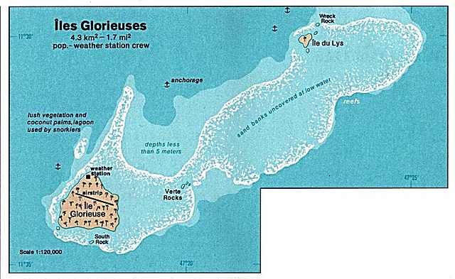
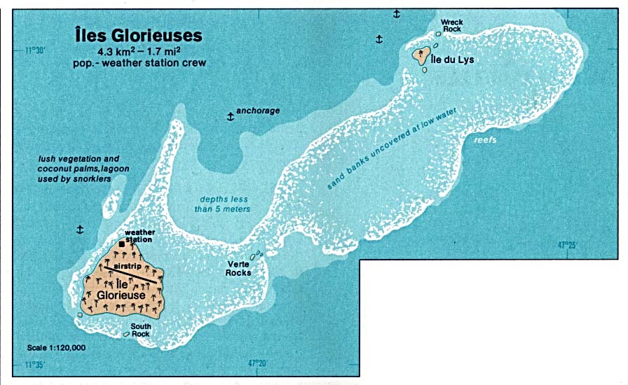
Deutsch: Karte der Îles Glorieuses im Indischen Ozean
English: Map of Glorioso Island in the Indian Ocean
Français : Carte d’îles Glorieuses dans l’océan Indien |
| दिनांक | |
| स्रोत | http://www.lib.utexas.edu/maps/islands_oceans_poles/iles_glorieuses_76.jpg |
| लेखक | Taken from Perry-Castañeda Library (PCL), originally from CIA Indian Ocean Atlas |
| अनुमति (इस चित्र का पुनः उपयोग करना) |
PD, see licensing |
लाइसेंस
| This image is a work of a Central Intelligence Agency employee, taken or made as part of that person's official duties. As a Work of the United States Government, this image or media is in the public domain in the United States.
|

|
चित्र का इतिहास
फ़ाइलका पुराना अवतरण देखने के लिये दिनांक/समय पर क्लिक करें।
| दिनांक/समय | थंबनेल | आकार | सदस्य | प्रतिक्रिया | |
|---|---|---|---|---|---|
| वर्तमान | 05:36, 3 फ़रवरी 2005 | | 896 × 550 (102 KB) | Dysprosia~commonswiki | {{PD-PCL|http://www.lib.utexas.edu/maps/islands_oceans_poles/iles_glorieuses_76.jpg}} |
चित्र का उपयोग
निम्नलिखित पन्ने इस चित्र से जुडते हैं :
चित्र का वैश्विक उपयोग
इस चित्र का उपयोग इन दूसरे विकियों में किया जाता है:
- ar.wikipedia.org पर उपयोग
- az.wikipedia.org पर उपयोग
- be.wikipedia.org पर उपयोग
- cs.wikipedia.org पर उपयोग
- el.wikipedia.org पर उपयोग
- en.wikipedia.org पर उपयोग
- eo.wikipedia.org पर उपयोग
- es.wikipedia.org पर उपयोग
- fa.wikipedia.org पर उपयोग
- fr.wikipedia.org पर उपयोग
- gl.wikipedia.org पर उपयोग
- hr.wikipedia.org पर उपयोग
- hu.wikipedia.org पर उपयोग
- id.wikipedia.org पर उपयोग
- ja.wikipedia.org पर उपयोग
- ka.wikipedia.org पर उपयोग
- lij.wikipedia.org पर उपयोग
- mk.wikipedia.org पर उपयोग
- nl.wikipedia.org पर उपयोग
- no.wikipedia.org पर उपयोग
- pl.wikipedia.org पर उपयोग
- ru.wikipedia.org पर उपयोग
- sh.wikipedia.org पर उपयोग
- sr.wikipedia.org पर उपयोग
- sv.wikipedia.org पर उपयोग
- uk.wikipedia.org पर उपयोग
- ur.wikipedia.org पर उपयोग
- vi.wikipedia.org पर उपयोग
- zh.wikipedia.org पर उपयोग