
चित्र:GoldenHorde1300.png

इस पूर्वावलोकन का आकार: 800 × 481 पिक्सेल। दूसरे रेसोल्यूशन्स: 320 × 193 पिक्सेल | 640 × 385 पिक्सेल | 1,024 × 616 पिक्सेल | 1,436 × 864 पिक्सेल।
मूल चित्र ((1,436 × 864 पिक्सेल, फ़ाइल का आकार: 47 KB, MIME प्रकार: image/png))
|
|
यह फ़ाइल विकिमेडिया कॉमन्स से है। वहाँ पर इसका विवरण पृष्ठ निम्नोक्त है। कॉमन्स मुक्त लाइसेंसों के अंतर्गत उपलब्ध मीडिया फ़ाइलों का संग्रह है। आप भी इसमें मदद कर सकते हैं। |

|
This map image could be re-created using vector graphics as an SVG file. This has several advantages; see Commons:Media for cleanup for more information. If an SVG form of this image is available, please upload it and afterwards replace this template with
{{vector version available|new image name}}.
It is recommended to name the SVG file “GoldenHorde1300.svg”—then the template Vector version available (or Vva) does not need the new image name parameter. |
सारांश
| विवरण |
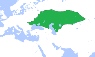
English: Locator map of the Golden Horde, c. 1300.
(Partially based on Atlas of World History (2007) - The World 1200-1300, map) |
| दिनांक | |
| स्रोत | अपना कार्य |
| लेखक | Gabagool |
लाइसेंस
मैं, इस कार्य का/की कॉपीराइट धारक, इसे निम्न लाइसेंस के अंतर्गत प्रकाशित करता/करती हूँ:
इस फ़ाइल को क्रिएटिव कॉमन्स श्रेय 3.0 अनरिपोर्टेड लाइसेंस के अंतर्गत लाइसेंस किया गया है।
- आप खुलकर:
- बाँट सकते हैं – रचना की प्रतिलिपि बना सकते हैं, बाँँट सकते हैं और संचारित कर सकते हैं
- रीमिक्स कर सकते हैं – कार्य को अनुकूलित कर सकते हैं
- निम्नलिखित शर्तों के अंतर्गत:
- श्रेय – यह अनिवार्य है कि आप यथोचित श्रेय प्रदान करें, लाइसेंस की कड़ी प्रदान करें, और अगर कोई बदलाव हुए हों तो उन्हें इंगित करें। आप ऐसा किसी भी उचित तरीके से कर सकते हैं, लेकिन किसी भी तरह उससे यह नहीं संकेत नहीं किया जाना चाहिए कि लाइसेंसधारी द्वारा आपको अथवा आपके इस प्रयोग का समर्थन किया जा रहा हो।
चित्र का इतिहास
फ़ाइलका पुराना अवतरण देखने के लिये दिनांक/समय पर क्लिक करें।
| दिनांक/समय | थंबनेल | आकार | सदस्य | प्रतिक्रिया | |
|---|---|---|---|---|---|
| वर्तमान | 15:58, 16 नवम्बर 2022 | | 1,436 × 864 (47 KB) | Gyalu22 | Reverted to version as of 16:08, 5 June 2009 (UTC) |
| 16:12, 7 जून 2021 |  | 1,436 × 864 (28 KB) | Devlet Geray | Reverted to version as of 11:20, 4 June 2018 (UTC) they paid tribute to the Khan and because of this could trade but there were no independent states in Southern Crimea | |
| 12:04, 4 जून 2018 |  | 1,436 × 864 (28 KB) | Julieta39 | No Golden Horde control on the Southern Crimea (byzantine, later Theodoro principality) | |
| 11:20, 4 जून 2018 |  | 1,436 × 864 (28 KB) | Julieta39 | Shorelines, no modern dam lakes, Hungary and Galicia no ruled by Golden Horde | |
| 16:08, 5 जून 2009 |  | 1,436 × 864 (47 KB) | Gabagool | slightly cropped | |
| 13:00, 25 अप्रैल 2009 |  | 1,644 × 959 (56 KB) | Gabagool | {{Information |Description={{en|1=Locator map of the Golden Horde, c. 1300. (Partially based on ''Atlas of World History'' (2007) - The World 1200-1300, map)}} |Source=Own work by uploader |Author=Gabagool / Jarle Grøhn |Date=2009-04-2 |
चित्र का उपयोग
निम्नलिखित पन्ने इस चित्र से जुडते हैं :
चित्र का वैश्विक उपयोग
इस चित्र का उपयोग इन दूसरे विकियों में किया जाता है:
- af.wikipedia.org पर उपयोग
- ar.wikipedia.org पर उपयोग
- arz.wikipedia.org पर उपयोग
- ast.wikipedia.org पर उपयोग
- azb.wikipedia.org पर उपयोग
- az.wikipedia.org पर उपयोग
- be.wikipedia.org पर उपयोग
- bs.wikipedia.org पर उपयोग
- ca.wikipedia.org पर उपयोग
- cs.wikipedia.org पर उपयोग
- cv.wikipedia.org पर उपयोग
- cy.wikipedia.org पर उपयोग
- da.wikipedia.org पर उपयोग
- el.wikipedia.org पर उपयोग
- en.wikipedia.org पर उपयोग
- eo.wikipedia.org पर उपयोग
- es.wikipedia.org पर उपयोग
- et.wikipedia.org पर उपयोग
- eu.wikipedia.org पर उपयोग
- fa.wikipedia.org पर उपयोग
- fr.wikipedia.org पर उपयोग
- ga.wikipedia.org पर उपयोग
- gl.wikipedia.org पर उपयोग
- hr.wikipedia.org पर उपयोग
- hu.wikipedia.org पर उपयोग
- hy.wikipedia.org पर उपयोग
- id.wikipedia.org पर उपयोग
- incubator.wikimedia.org पर उपयोग
- it.wikipedia.org पर उपयोग
इस चित्र के वैश्विक उपयोग की अधिक जानकारी देखें।