
चित्र:Golan heights rel89-orig.jpg

इस पूर्वावलोकन का आकार: 474 × 599 पिक्सेल। दूसरे रेसोल्यूशन्स: 190 × 240 पिक्सेल | 380 × 480 पिक्सेल | 974 × 1,231 पिक्सेल।
मूल चित्र ((974 × 1,231 पिक्सेल, फ़ाइल का आकार: 245 KB, MIME प्रकार: image/jpeg))
|
|
यह फ़ाइल विकिमेडिया कॉमन्स से है। वहाँ पर इसका विवरण पृष्ठ निम्नोक्त है। कॉमन्स मुक्त लाइसेंसों के अंतर्गत उपलब्ध मीडिया फ़ाइलों का संग्रह है। आप भी इसमें मदद कर सकते हैं। |
| विवरण |
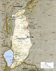
English: CIA map of the Golan Heights showing Israeli settlements and Syrian villages as of 1989 |
|||
| दिनांक | ||||
| स्रोत | http://www.lib.utexas.edu/maps/middle_east_and_asia/golan_heights_rel89.jpg | |||
| लेखक | CIA | |||
| अनुमति (इस चित्र का पुनः उपयोग करना) |
|

चित्र का इतिहास
फ़ाइलका पुराना अवतरण देखने के लिये दिनांक/समय पर क्लिक करें।
| दिनांक/समय | थंबनेल | आकार | सदस्य | प्रतिक्रिया | |
|---|---|---|---|---|---|
| वर्तमान | 15:15, 7 जुलाई 2009 | | 974 × 1,231 (245 KB) | Nableezy | {{Information |Description={{en|1=CIA map of the Golan Height showing Israeli settlements and Syrian villages as of 1989}} |Source=http://www.lib.utexas.edu/maps/middle_east_and_asia/golan_heights_rel89.jpg |Author=CIA |Date=1989 |Permission={{PD-USGov-CI |
चित्र का उपयोग
निम्नलिखित पन्ने इस चित्र से जुडते हैं :
चित्र का वैश्विक उपयोग
इस चित्र का उपयोग इन दूसरे विकियों में किया जाता है:
- ar.wikipedia.org पर उपयोग
- arz.wikipedia.org पर उपयोग
- be-tarask.wikipedia.org पर उपयोग
- bg.wikipedia.org पर उपयोग
- ca.wikipedia.org पर उपयोग
- csb.wikipedia.org पर उपयोग
- cs.wikipedia.org पर उपयोग
- da.wikipedia.org पर उपयोग
- en.wikipedia.org पर उपयोग
- es.wikipedia.org पर उपयोग
- fy.wikipedia.org पर उपयोग
- hy.wikipedia.org पर उपयोग
- id.wikipedia.org पर उपयोग
- incubator.wikimedia.org पर उपयोग
- it.wikipedia.org पर उपयोग
- ka.wikipedia.org पर उपयोग
- lt.wikipedia.org पर उपयोग
- ms.wikipedia.org पर उपयोग
- nl.wikipedia.org पर उपयोग
- nn.wikipedia.org पर उपयोग
- no.wikipedia.org पर उपयोग
- pl.wikipedia.org पर उपयोग
- pnb.wikipedia.org पर उपयोग
- pt.wikibooks.org पर उपयोग
- ru.wikipedia.org पर उपयोग
- uk.wikipedia.org पर उपयोग
- vi.wikipedia.org पर उपयोग
- www.wikidata.org पर उपयोग
- xmf.wikipedia.org पर उपयोग
- zh.wikipedia.org पर उपयोग