
चित्र:Floristic regions in Europe (english).png

इस पूर्वावलोकन का आकार: 751 × 600 पिक्सेल। दूसरे रेसोल्यूशन्स: 301 × 240 पिक्सेल | 601 × 480 पिक्सेल | 962 × 768 पिक्सेल | 1,280 × 1,022 पिक्सेल | 1,797 × 1,435 पिक्सेल।
मूल चित्र ((1,797 × 1,435 पिक्सेल, फ़ाइल का आकार: 1.95 MB, MIME प्रकार: image/png))
|
|
यह फ़ाइल विकिमेडिया कॉमन्स से है। वहाँ पर इसका विवरण पृष्ठ निम्नोक्त है। कॉमन्स मुक्त लाइसेंसों के अंतर्गत उपलब्ध मीडिया फ़ाइलों का संग्रह है। आप भी इसमें मदद कर सकते हैं। |
.png)
सारांश
| विवरण |
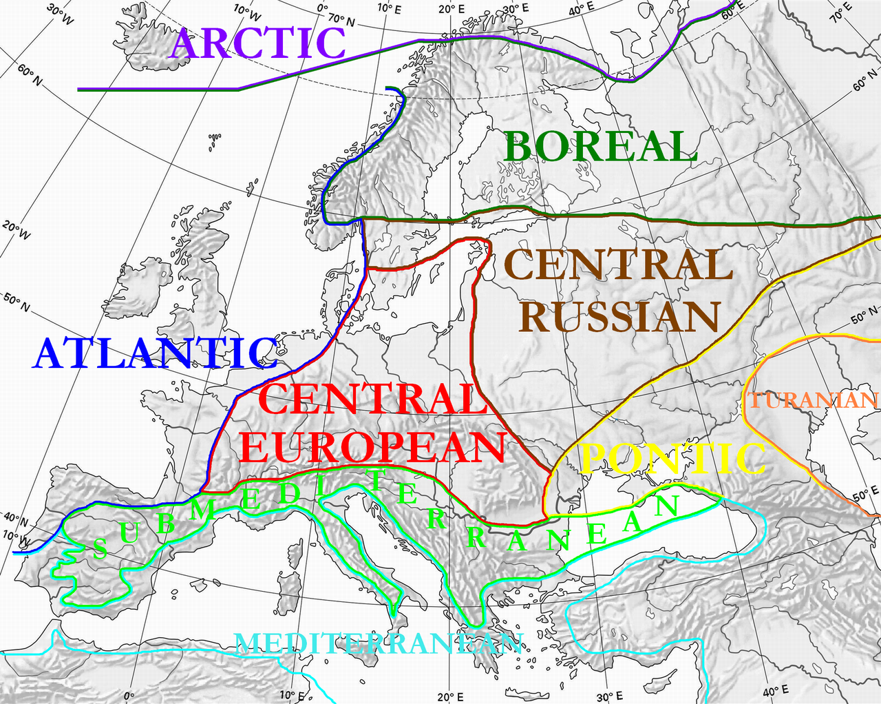
English: Floristic regions in Europe and western Siberia, according to Wolfgang Frey and Rainer Lösch
Français : Régions floristiques européennes actuelles (Europe et Siberie occidentale), selon Wolfgang Frey et Rainer Lösch |
| दिनांक | |
| स्रोत | अपना कार्य |
| लेखक | User:Olahus |
| दूसरे संस्करण | Derivative works of this file: Floristic regions in Europe-de.png |

|
This biogeographical map image could be re-created using vector graphics as an SVG file. This has several advantages; see Commons:Media for cleanup for more information. If an SVG form of this image is available, please upload it and afterwards replace this template with
{{vector version available|new image name}}.
It is recommended to name the SVG file “Floristic regions in Europe (english).svg”—then the template Vector version available (or Vva) does not need the new image name parameter. |
लाइसेंस
| मैं, इस कार्य का/की कॉपीराइट धारक, इस कार्य को सार्वजनिक डोमेन में प्रकाशित करता/करती हूँ। यह पूरे विश्व में लागू होता है। कुछ देशों में यह कानूनी तौर पर नहीं हो सकता है; ऐसा हो तो: मैं सभी को इस कार्य का इस्तेमाल किसी भी उद्देश्य से, बिना किसी बाधाओं के इन शर्तों के कानून द्वारा अनिवार्य किए तक करने की अनुमति देता/देती हूँ। |
चित्र का इतिहास
फ़ाइलका पुराना अवतरण देखने के लिये दिनांक/समय पर क्लिक करें।
| दिनांक/समय | थंबनेल | आकार | सदस्य | प्रतिक्रिया | |
|---|---|---|---|---|---|
| वर्तमान | 00:36, 3 जुलाई 2010 | | 1,797 × 1,435 (1.95 MB) | Ras67 | cropped |
| 22:15, 28 मार्च 2008 |  | 1,800 × 1,442 (2.17 MB) | Olahus | {{Information |Description=Floristic regions in Europe and western Siberia, according to Wolfgang Frey and Rainer Lösch |Source=own work |Date=2008 |Author= Olahus |Permission= |other_versions= }} |
चित्र का उपयोग
निम्नलिखित पन्ने इस चित्र से जुडते हैं :
चित्र का वैश्विक उपयोग
इस चित्र का उपयोग इन दूसरे विकियों में किया जाता है:
- ar.wikipedia.org पर उपयोग
- bn.wikipedia.org पर उपयोग
- br.wikipedia.org पर उपयोग
- bs.wikipedia.org पर उपयोग
- ca.wikipedia.org पर उपयोग
- cs.wikipedia.org पर उपयोग
- el.wikipedia.org पर उपयोग
- en.wikipedia.org पर उपयोग
- eo.wikipedia.org पर उपयोग
- es.wikipedia.org पर उपयोग
- fa.wikipedia.org पर उपयोग
- fi.wikipedia.org पर उपयोग
- frp.wikipedia.org पर उपयोग
- fr.wikipedia.org पर उपयोग
- gl.wikipedia.org पर उपयोग
- hu.wikipedia.org पर उपयोग
- hy.wikipedia.org पर उपयोग
- it.wikipedia.org पर उपयोग
- ja.wikipedia.org पर उपयोग
- kk.wikipedia.org पर उपयोग
- ko.wikipedia.org पर उपयोग
इस चित्र के वैश्विक उपयोग की अधिक जानकारी देखें।
.png)
.png)