
चित्र:Dallas County Texas Incorporated Areas Dallas highlighted.svg

पूर्वावलोकन PNG का आकार SVG फ़ाइल: 800 × 457 पिक्सेल दूसरे रेसोल्यूशन्स: 320 × 183 पिक्सेल | 640 × 366 पिक्सेल | 1,024 × 585 पिक्सेल | 1,280 × 731 पिक्सेल | 2,560 × 1,463 पिक्सेल।
मूल चित्र (SVG फ़ाइल, साधारणतः 1,050 × 600 पिक्सेल, फ़ाइल का आकार: 248 KB)
|
|
यह फ़ाइल विकिमेडिया कॉमन्स से है। वहाँ पर इसका विवरण पृष्ठ निम्नोक्त है। कॉमन्स मुक्त लाइसेंसों के अंतर्गत उपलब्ध मीडिया फ़ाइलों का संग्रह है। आप भी इसमें मदद कर सकते हैं। |
सारांश
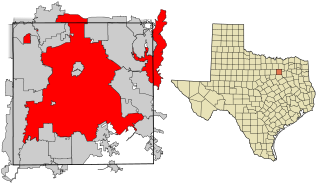
| विवरण | This map shows the incorporated areas in Dallas County, Texas. Dallas is highlighted in red. I created it in Inkscape using data from the following links: North Central Texas Council of Governments Maps Website, Dallas County Commissioner District Map (PDF) |
| दिनांक | |
| स्रोत | My own work, based on government information. Though I strove to be as accurate in the detail as possible, the information shown is not guaranteed to be completely accurate. |
| लेखक | Ixnayonthetimmay |
| अनुमति (इस चित्र का पुनः उपयोग करना) |
Public Domain |
| दूसरे संस्करण | See Category:Maps of Dallas County, Texas for other versions of this image. |
लाइसेंस
| मैं, इस कार्य का/की कॉपीराइट धारक, इस कार्य को सार्वजनिक डोमेन में प्रकाशित करता/करती हूँ। यह पूरे विश्व में लागू होता है। कुछ देशों में यह कानूनी तौर पर नहीं हो सकता है; ऐसा हो तो: मैं सभी को इस कार्य का इस्तेमाल किसी भी उद्देश्य से, बिना किसी बाधाओं के इन शर्तों के कानून द्वारा अनिवार्य किए तक करने की अनुमति देता/देती हूँ। |
चित्र का इतिहास
फ़ाइलका पुराना अवतरण देखने के लिये दिनांक/समय पर क्लिक करें।
| दिनांक/समय | थंबनेल | आकार | सदस्य | प्रतिक्रिया | |
|---|---|---|---|---|---|
| वर्तमान | 18:27, 9 अगस्त 2007 | | 1,050 × 600 (248 KB) | Ixnayonthetimmay | == Summary == {{Information |Description=This map shows the incorporated areas in Dallas County, Texas. Dallas is highlighted in red. I created it in [[en:Inkscape|Inkscape] |
चित्र का उपयोग
इस चित्र से कोई पन्ने नहीं जुड़ते
चित्र का वैश्विक उपयोग
इस चित्र का उपयोग इन दूसरे विकियों में किया जाता है:
- als.wikipedia.org पर उपयोग
- ar.wikipedia.org पर उपयोग
- bn.wikipedia.org पर उपयोग
- br.wikipedia.org पर उपयोग
- ckb.wikipedia.org पर उपयोग
- de.wikipedia.org पर उपयोग
- en.wikipedia.org पर उपयोग
- fa.wikipedia.org पर उपयोग
- fi.wikipedia.org पर उपयोग
- fo.wikipedia.org पर उपयोग
- fr.wikipedia.org पर उपयोग
- fy.wikipedia.org पर उपयोग
- he.wikipedia.org पर उपयोग
- id.wikipedia.org पर उपयोग
- io.wikipedia.org पर उपयोग
- it.wikipedia.org पर उपयोग
- ja.wikipedia.org पर उपयोग
- ln.wikipedia.org पर उपयोग
- lv.wikipedia.org पर उपयोग
- ml.wikipedia.org पर उपयोग
- ms.wikipedia.org पर उपयोग
- my.wikipedia.org पर उपयोग
- nl.wikipedia.org पर उपयोग
- no.wikipedia.org पर उपयोग
- pnb.wikipedia.org पर उपयोग
- pt.wikipedia.org पर उपयोग
- qu.wikipedia.org पर उपयोग
- ro.wikipedia.org पर उपयोग
- sco.wikipedia.org पर उपयोग
- sc.wikipedia.org पर उपयोग
- sl.wikipedia.org पर उपयोग
- smn.wikipedia.org पर उपयोग
- srn.wikipedia.org पर उपयोग
- sv.wikipedia.org पर उपयोग
- ta.wikipedia.org पर उपयोग
- te.wikipedia.org पर उपयोग
- th.wikipedia.org पर उपयोग
- tl.wikipedia.org पर उपयोग
- tr.wikipedia.org पर उपयोग
- ug.wikipedia.org पर उपयोग
- ur.wikipedia.org पर उपयोग
- vi.wikipedia.org पर उपयोग
- yo.wikipedia.org पर उपयोग