
चित्र:Adyar estuary.jpg

इस पूर्वावलोकन का आकार: 800 × 364 पिक्सेल। दूसरे रेसोल्यूशन्स: 320 × 146 पिक्सेल | 640 × 291 पिक्सेल | 1,443 × 657 पिक्सेल।
मूल चित्र ((1,443 × 657 पिक्सेल, फ़ाइल का आकार: 249 KB, MIME प्रकार: image/jpeg))
|
|
यह फ़ाइल विकिमेडिया कॉमन्स से है। वहाँ पर इसका विवरण पृष्ठ निम्नोक्त है। कॉमन्स मुक्त लाइसेंसों के अंतर्गत उपलब्ध मीडिया फ़ाइलों का संग्रह है। आप भी इसमें मदद कर सकते हैं। |
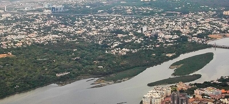
| विवरण | Aerial view of the Adyar Estuary and w:Adyar. On the top ind is w:Tidel Park and the w:Chennai MRTS. The gardens belong to the w:Theosophical Society. | ||
| दिनांक | 22 June 05 | ||
| स्रोत | अपना कार्य | ||
| लेखक |
|
||
| अनुमति (इस चित्र का पुनः उपयोग करना) |
मैं, इस कार्य का/की कॉपीराइट धारक, इसे निम्न लाइसेंस के अंतर्गत प्रकाशित करता/करती हूँ: इस फ़ाइल को क्रिएटिव कॉमन्स श्रेय-समानसांझा 2.5 साधारण लाइसेंस के अंतर्गत लाइसेंस किया गया है।
|
| कैमरा स्थान | | यह और अन्य आसपास की छवियों यहां पर देखें: ओपन स्ट्रीट मैप |
|---|
चित्र का इतिहास
फ़ाइलका पुराना अवतरण देखने के लिये दिनांक/समय पर क्लिक करें।
| दिनांक/समय | थंबनेल | आकार | सदस्य | प्रतिक्रिया | |
|---|---|---|---|---|---|
| वर्तमान | 12:16, 28 अप्रैल 2007 | | 1,443 × 657 (249 KB) | Planemad | {{Information |Description=Aerial view of the Adyar Estuary and w:Adyar. On the top ind is w:Tidel Park and the w:Chennai MRTS. |Source=own work |Date= 22 June 05 |Author= w:user:PlaneMad |Permission={{self|cc-by-sa-2.5}} |
चित्र का उपयोग
निम्नलिखित पन्ने इस चित्र से जुडते हैं :
चित्र का वैश्विक उपयोग
इस चित्र का उपयोग इन दूसरे विकियों में किया जाता है:
- arz.wikipedia.org पर उपयोग
- azb.wikipedia.org पर उपयोग
- bg.wikipedia.org पर उपयोग
- bn.wikipedia.org पर उपयोग
- ceb.wikipedia.org पर उपयोग
- cs.wikipedia.org पर उपयोग
- de.wikipedia.org पर उपयोग
- en.wikipedia.org पर उपयोग
- es.wikipedia.org पर उपयोग
- fa.wikipedia.org पर उपयोग
- fi.wikipedia.org पर उपयोग
- fr.wikipedia.org पर उपयोग
- id.wikipedia.org पर उपयोग
- incubator.wikimedia.org पर उपयोग
- io.wikipedia.org पर उपयोग
- it.wikipedia.org पर उपयोग
- jv.wikipedia.org पर उपयोग
- ml.wikipedia.org पर उपयोग
- nl.wikipedia.org पर उपयोग
- no.wikipedia.org पर उपयोग
- pt.wikipedia.org पर उपयोग
- ro.wikipedia.org पर उपयोग
- ru.wikipedia.org पर उपयोग
- ta.wikipedia.org पर उपयोग
- uk.wikipedia.org पर उपयोग
- ur.wikipedia.org पर उपयोग
- www.wikidata.org पर उपयोग
- zh-min-nan.wikipedia.org पर उपयोग
- zh-yue.wikipedia.org पर उपयोग