
चित्र:Sinai-peninsula-map.jpg

इस पूर्वावलोकन का आकार: 483 × 600 पिक्सेल। दूसरे रेसोल्यूशन्स: 193 × 240 पिक्सेल | 387 × 480 पिक्सेल | 941 × 1,168 पिक्सेल।
मूल चित्र ((941 × 1,168 पिक्सेल, फ़ाइल का आकार: 665 KB, MIME प्रकार: image/jpeg))
|
|
यह फ़ाइल विकिमेडिया कॉमन्स से है। वहाँ पर इसका विवरण पृष्ठ निम्नोक्त है। कॉमन्स मुक्त लाइसेंसों के अंतर्गत उपलब्ध मीडिया फ़ाइलों का संग्रह है। आप भी इसमें मदद कर सकते हैं। |
فلسطين
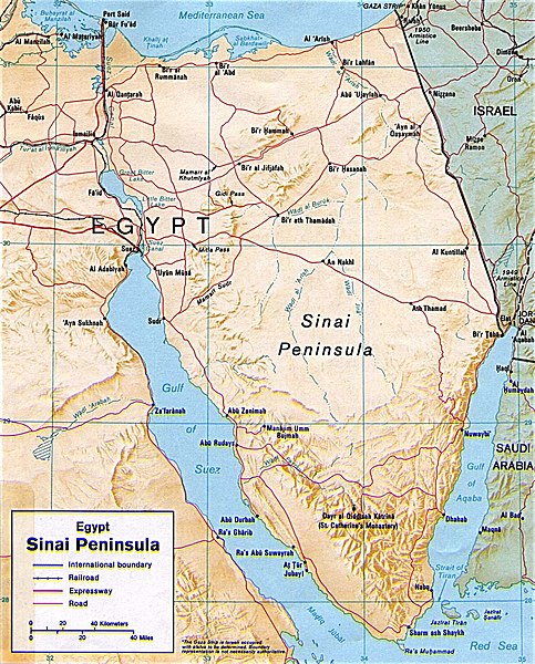
सारांश
| विवरण | Shaded relief map of the Sinai Peninsula, 1992, produced by the U.S. Central Intelligence Agency. |
| दिनांक | |
| स्रोत | University of Texas Libraries, Perry-Castañeda Library Map Collection: Egypt Maps |
| लेखक | CIA |
| दूसरे संस्करण |
|


लाइसेंस
| This image is a work of a Central Intelligence Agency employee, taken or made as part of that person's official duties. As a Work of the United States Government, this image or media is in the public domain in the United States.
|

|
चित्र का इतिहास
फ़ाइलका पुराना अवतरण देखने के लिये दिनांक/समय पर क्लिक करें।
| दिनांक/समय | थंबनेल | आकार | सदस्य | प्रतिक्रिया | |
|---|---|---|---|---|---|
| वर्तमान | 20:45, 12 मई 2011 | | 941 × 1,168 (665 KB) | Ras67 | cropped |
| 22:58, 4 मार्च 2007 |  | 956 × 1,196 (307 KB) | Joao Xavier | Map of the Sinai Peninsula. (U.S. Central Intelligence Agency, https://www.cia.gov/cia/publications/mapspub/index.shtml) originally found on University of Texas library website (http://www.lib.utexas.edu/maps/middle_east_and_asia/sinai.jpg) and claimed as |
चित्र का उपयोग
निम्नलिखित पन्ने इस चित्र से जुडते हैं :
चित्र का वैश्विक उपयोग
इस चित्र का उपयोग इन दूसरे विकियों में किया जाता है:
- af.wikipedia.org पर उपयोग
- als.wikipedia.org पर उपयोग
- ar.wikipedia.org पर उपयोग
- ast.wikipedia.org पर उपयोग
- azb.wikipedia.org पर उपयोग
- az.wikipedia.org पर उपयोग
- az.wiktionary.org पर उपयोग
- ba.wikipedia.org पर उपयोग
- bn.wikipedia.org पर उपयोग
- bs.wikipedia.org पर उपयोग
- ca.wikipedia.org पर उपयोग
- cs.wikipedia.org पर उपयोग
- da.wikipedia.org पर उपयोग
- de.wikipedia.org पर उपयोग
- de.wikinews.org पर उपयोग
- de.wiktionary.org पर उपयोग
- diq.wikipedia.org पर उपयोग
- el.wikipedia.org पर उपयोग
- el.wiktionary.org पर उपयोग
- en.wikipedia.org पर उपयोग
- eo.wikipedia.org पर उपयोग
- es.wikipedia.org पर उपयोग
- eu.wikipedia.org पर उपयोग
इस चित्र के वैश्विक उपयोग की अधिक जानकारी देखें।