
चित्र:NepalTanahuDistrictmap.png
मूल चित्र ((3,508 × 2,479 पिक्सेल, फ़ाइल का आकार: 339 KB, MIME प्रकार: image/png))
|
|
यह फ़ाइल विकिमेडिया कॉमन्स से है। वहाँ पर इसका विवरण पृष्ठ निम्नोक्त है। कॉमन्स मुक्त लाइसेंसों के अंतर्गत उपलब्ध मीडिया फ़ाइलों का संग्रह है। आप भी इसमें मदद कर सकते हैं। |
सारांश
| विवरण |
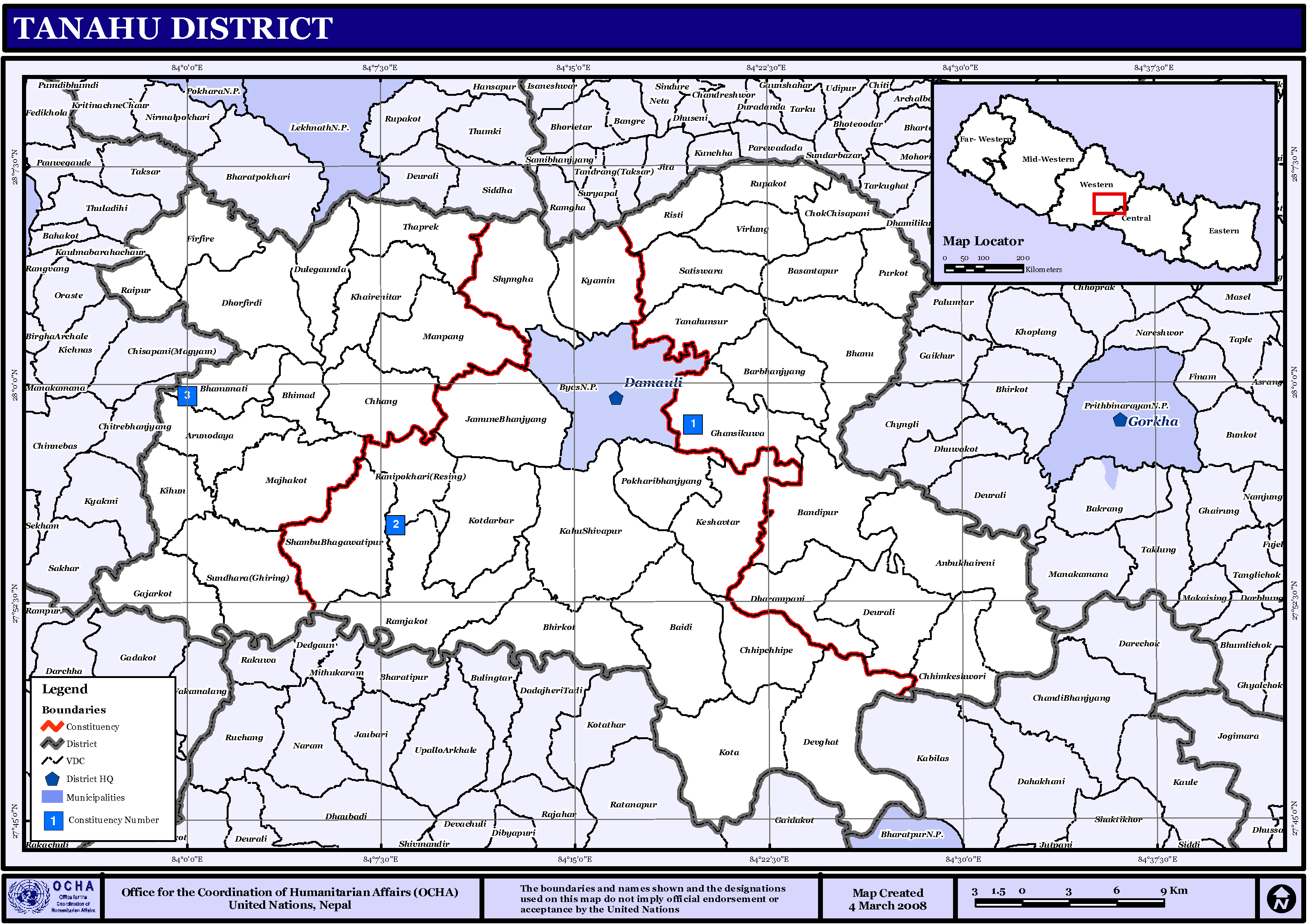
English: Map displaying Village Development Committees in Tanahu District, Nepal |
| दिनांक | |
| स्रोत | http://www.un.org.np/maps/district-maps/western/Tanahu.pdf |
| लेखक | United Nations |
लाइसेंस
| This image is a map derived from a United Nations map.
Unless stated otherwise, UN maps are to be considered in the public domain. This applies worldwide. UN maps are, in principle, open source material and you can use them in your work or for making your own map. UN requests however that you delete the UN name, logo and reference number upon any modification to the map. Content of your map will be your responsibility. You can state in your publication, if you wish, something like: based on UN map … (map name, map number, revision number and date). See: Geospatial Information Section. And: Geospatial, location data for a better world. |
 |
चित्र का इतिहास
फ़ाइलका पुराना अवतरण देखने के लिये दिनांक/समय पर क्लिक करें।
| दिनांक/समय | थंबनेल | आकार | सदस्य | प्रतिक्रिया | |
|---|---|---|---|---|---|
| वर्तमान | 18:55, 15 नवम्बर 2008 | | 3,508 × 2,479 (339 KB) | Sadalmelik | {{Information |Description={{en|1=Map displaying Village Development Committees in Tanahu District, Nepal}} |Source=http://www.un.org.np/maps/district-maps/western/Tanahu.pdf |Date=March 4, 2008 |Author=United Nations |Permission= |other_versions= }} |
चित्र का उपयोग
निम्नलिखित पन्ने इस चित्र से जुडते हैं :
- अरुनोदय
- आँबुखैरेनी
- काहूँशिवपुर
- किहूँ
- केशवटार
- कोटदरबार
- कोटा, तनहुँ
- क्यामीन-थप्रेक
- गजरकोट
- ग्राम विकास समिति
- घाँसीकुवा
- चोकचिसापानी
- छाङ
- छिपछिपे
- छिम्केश्वरी
- जामुने
- तनहुँ जिला
- तनहुँसुर
- थुप्रेक
- देउराली गाविस, तनहुँ
- देवघाट गाविस
- पुर्कोट
- पोखरी भञ्ज्याङ
- फिरफिरे गाविस
- बन्दीपुर नगरपालिका
- बसन्तपुर-रुपाकोट
- बैदी
- भगवतीपुर, तनहुँ
- भानु-बरभञ्ज्याङ
- भानुमती
- भिमाद
- भिरकोट, तनहुँ
- मनपाङ
- माझकोट तनहुँ
- मिर्लुङ
- राईपुर
- रानीपोखरी गाविस
- राम्जाकोट
- रिस्ती
- रुपाकोट, तनहुँ
- व्यास नगरपालिका
- शुक्लगण्डकी नगरपालिका
- श्याम्घा
- सुन्धारा गाविस
- साँचा:तनहुँ जिला
चित्र का वैश्विक उपयोग
इस चित्र का उपयोग इन दूसरे विकियों में किया जाता है:
- de.wikipedia.org पर उपयोग
- en.wikipedia.org पर उपयोग
- fi.wikipedia.org पर उपयोग
- mai.wikipedia.org पर उपयोग
- तनहुँ जिला
- आकृति:तनहुँ जिलाक गाविस तथा नगरपालिकासभ
- काहूँशिवपुर
- अरुनोदय
- किहूँ
- कोटा
- कोटदरबार
- क्यामिन
- केशवटार
- तनहुँसुर
- गजरकोट
- घाँसीकुवा
- छाङ
- जामुने
- छिम्केश्वरी
- छिपछिपे
- चोकचिसापानी
- पुर्कोट
- देउराली गाविस, तनहुँ
- देवघाट गाविस
- फिरफिरे गाविस
- पोखरी भञ्ज्याङ
- बसन्तपुर, तनहुँ
- थुप्रेक
- भानुमती
- भिरकोट, तनहुँ
- भिमाद
- बैदी
- भगवतीपुर, तनहुँ
- मनपाङ
- माझकोट तनहुँ
- मिर्लुङ
- राईपुर
- श्याम्घा
- राम्जाकोट
- रिस्ती
- रानीपोखरी गाविस
- रुपाकोट, तनहुँ
- सुन्धारा गाविस
- शुक्लगण्डकी नगरपालिका
- आँबुखैरेनी नगरपालिका
- व्यास नगरपालिका
- भानु नगरपालिका
- श्रेणी:तनहुँ जिलाक गाविससभ
इस चित्र के वैश्विक उपयोग की अधिक जानकारी देखें।