
चित्र:Kamarupa 7th-8th Century AD.jpg
इस पूर्वावलोकन का आकार: 800 × 600 पिक्सेल। दूसरे रेसोल्यूशन्स: 320 × 240 पिक्सेल | 640 × 480 पिक्सेल | 960 × 720 पिक्सेल।
मूल चित्र ((960 × 720 पिक्सेल, फ़ाइल का आकार: 485 KB, MIME प्रकार: image/jpeg))
|
|
यह फ़ाइल विकिमेडिया कॉमन्स से है। वहाँ पर इसका विवरण पृष्ठ निम्नोक्त है। कॉमन्स मुक्त लाइसेंसों के अंतर्गत उपलब्ध मीडिया फ़ाइलों का संग्रह है। आप भी इसमें मदद कर सकते हैं। |

सारांश
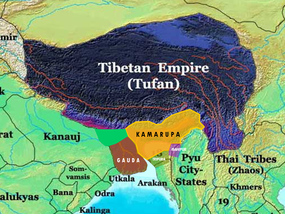
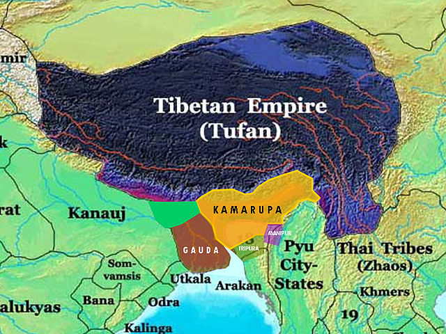
| विवरण | This is the 7th and 8th century extent of Kamarupa kingdom in Assam. The map is created using historical data from reliable books and on the basis of archaeological findings in this region. |
| स्रोत | अपना कार्य |
| लेखक | Porikolpok Oxom |
लाइसेंस
मैं, इस कार्य का/की कॉपीराइट धारक, इसे निम्न लाइसेंस के अंतर्गत प्रकाशित करता/करती हूँ:
इस फ़ाइल को क्रिएटिव कॉमन्स श्रेय-समानसांझा 3.0 अनरिपोर्टेड लाइसेंस के अंतर्गत लाइसेंस किया गया है।
- आप खुलकर:
- बाँट सकते हैं – रचना की प्रतिलिपि बना सकते हैं, बाँँट सकते हैं और संचारित कर सकते हैं
- रीमिक्स कर सकते हैं – कार्य को अनुकूलित कर सकते हैं
- निम्नलिखित शर्तों के अंतर्गत:
- श्रेय – यह अनिवार्य है कि आप यथोचित श्रेय प्रदान करें, लाइसेंस की कड़ी प्रदान करें, और अगर कोई बदलाव हुए हों तो उन्हें इंगित करें। आप ऐसा किसी भी उचित तरीके से कर सकते हैं, लेकिन किसी भी तरह उससे यह नहीं संकेत नहीं किया जाना चाहिए कि लाइसेंसधारी द्वारा आपको अथवा आपके इस प्रयोग का समर्थन किया जा रहा हो।
- समानसांझा – अगर आप इस रचना में कोई बदलाव करते हैं या इसपर आधारित कुछ रचित करते हैं तो आप अपने योगदान को सिर्फ इसी या इसके सामान किसी लाइसेंस के अंतर्गत बाँट सकते हैं।
चित्र का इतिहास
फ़ाइलका पुराना अवतरण देखने के लिये दिनांक/समय पर क्लिक करें।
| दिनांक/समय | थंबनेल | आकार | सदस्य | प्रतिक्रिया | |
|---|---|---|---|---|---|
| वर्तमान | 12:32, 16 मार्च 2008 | | 960 × 720 (485 KB) | Porikolpok Oxom~commonswiki | This is the 7th and 8th century extent of Kamarupa kingdom in Assam. The map is created using historical data from reliable books and on the basis of archaeological findings in this region. Revised with mouth of brahmaputra and ganges. |
| 11:35, 14 मार्च 2008 |  | 960 × 720 (492 KB) | Porikolpok Oxom~commonswiki | {{Information |Description= This is the 7th and 8th century extent of Kamarupa kingdom in Assam. The map is created using historical data from reliable books and on the basis of archaeological findings in this region. |Source=self-made |Date= |Author= |
चित्र का उपयोग
इस चित्र से कोई पन्ने नहीं जुड़ते
चित्र का वैश्विक उपयोग
इस चित्र का उपयोग इन दूसरे विकियों में किया जाता है: