
चित्र:European settlements in India 1501-1739.png

इस पूर्वावलोकन का आकार: 800 × 491 पिक्सेल। दूसरे रेसोल्यूशन्स: 320 × 196 पिक्सेल | 640 × 393 पिक्सेल | 1,140 × 700 पिक्सेल।
मूल चित्र ((1,140 × 700 पिक्सेल, फ़ाइल का आकार: 168 KB, MIME प्रकार: image/png))
|
|
यह फ़ाइल विकिमेडिया कॉमन्स से है। वहाँ पर इसका विवरण पृष्ठ निम्नोक्त है। कॉमन्स मुक्त लाइसेंसों के अंतर्गत उपलब्ध मीडिया फ़ाइलों का संग्रह है। आप भी इसमें मदद कर सकते हैं। |
सारांश
| विवरण |
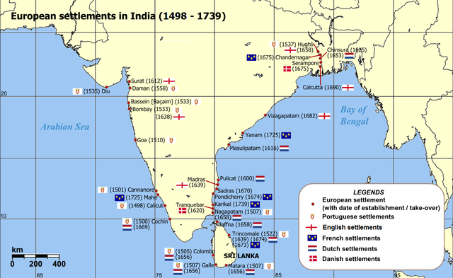
English: Map of India with Sri Lanka, illustrating locations of European settlements in the subcontinent between 1501 and 1739.
Norsk nynorsk: Kart over Sør-Asia med europeiske koloniar/busetjingar mellom 1501 og 1739.
Dansk: Kort af Indien inkl. Sri Lanka med europæiske kolonier mellem 1501 og 1739. |
| दिनांक | uploaded in 2006 |
| स्रोत |
Self-published work by Luis wiki Map reference: [1] at w:University of Pennsylvania, with reference varification from: [2] (URL accessed: 23-Mar-2006) |
| लेखक | Luis wiki |
| दूसरे संस्करण |
|

![[1]](http://www.history.upenn.edu/coursepages/hist086/material/schmidt26a.jpg)

|
This map of asia image could be re-created using vector graphics as an SVG file. This has several advantages; see Commons:Media for cleanup for more information. If an SVG form of this image is available, please upload it and afterwards replace this template with
{{vector version available|new image name}}.
It is recommended to name the SVG file “European settlements in India 1501-1739.svg”—then the template Vector version available (or Vva) does not need the new image name parameter. |
लाइसेंस
मैं, इस कार्य का/की कॉपीराइट धारक, इसे निम्न लाइसेंस के अंतर्गत प्रकाशित करता/करती हूँ:
इस फ़ाइल को क्रिएटिव कॉमन्स श्रेय-समानसांझा 2.5 साधारण लाइसेंस के अंतर्गत लाइसेंस किया गया है।
- आप खुलकर:
- बाँट सकते हैं – रचना की प्रतिलिपि बना सकते हैं, बाँँट सकते हैं और संचारित कर सकते हैं
- रीमिक्स कर सकते हैं – कार्य को अनुकूलित कर सकते हैं
- निम्नलिखित शर्तों के अंतर्गत:
- श्रेय – यह अनिवार्य है कि आप यथोचित श्रेय प्रदान करें, लाइसेंस की कड़ी प्रदान करें, और अगर कोई बदलाव हुए हों तो उन्हें इंगित करें। आप ऐसा किसी भी उचित तरीके से कर सकते हैं, लेकिन किसी भी तरह उससे यह नहीं संकेत नहीं किया जाना चाहिए कि लाइसेंसधारी द्वारा आपको अथवा आपके इस प्रयोग का समर्थन किया जा रहा हो।
- समानसांझा – अगर आप इस रचना में कोई बदलाव करते हैं या इसपर आधारित कुछ रचित करते हैं तो आप अपने योगदान को सिर्फ इसी या इसके सामान किसी लाइसेंस के अंतर्गत बाँट सकते हैं।
चित्र का इतिहास
फ़ाइलका पुराना अवतरण देखने के लिये दिनांक/समय पर क्लिक करें।
| दिनांक/समय | थंबनेल | आकार | सदस्य | प्रतिक्रिया | |
|---|---|---|---|---|---|
| वर्तमान | 14:47, 12 मार्च 2011 | | 1,140 × 700 (168 KB) | Luis wiki | Bombay, Portuguese from 1534, later on British |
| 22:30, 5 फ़रवरी 2011 |  | 1,140 × 700 (198 KB) | Henry Bottomley~commonswiki | Title date (see Calicut), Goa date, Flags of the time of Portugal, France and England | |
| 20:49, 2 मार्च 2010 |  | 1,140 × 700 (158 KB) | Brianski | Fix spelling of "Portuguese" | |
| 20:34, 22 फ़रवरी 2007 |  | 1,140 × 700 (214 KB) | Wereon | "CE" unnecessary | |
| 12:32, 23 मार्च 2006 |  | 1,140 × 700 (232 KB) | Miljoshi | Map of India with Sri Lanka, illustrating locations of European settlements in the subcontinent between 1501 and 1739 CE. Category:India |
चित्र का उपयोग
निम्नलिखित पन्ने इस चित्र से जुडते हैं :
चित्र का वैश्विक उपयोग
इस चित्र का उपयोग इन दूसरे विकियों में किया जाता है:
- af.wikipedia.org पर उपयोग
- ar.wikipedia.org पर उपयोग
- ast.wikipedia.org पर उपयोग
- as.wikipedia.org पर उपयोग
- azb.wikipedia.org पर उपयोग
- az.wikipedia.org पर उपयोग
- bn.wikipedia.org पर उपयोग
- br.wikipedia.org पर उपयोग
- ca.wikipedia.org पर उपयोग
- cs.wikipedia.org पर उपयोग
- da.wikipedia.org पर उपयोग
- da.wikibooks.org पर उपयोग
- de.wikipedia.org पर उपयोग
- el.wikipedia.org पर उपयोग
- en.wikipedia.org पर उपयोग
- eo.wikipedia.org पर उपयोग
- es.wikipedia.org पर उपयोग
इस चित्र के वैश्विक उपयोग की अधिक जानकारी देखें।