
चित्र:European Middle Neolithic.gif
इस पूर्वावलोकन का आकार: 800 × 397 पिक्सेल। दूसरे रेसोल्यूशन्स: 320 × 159 पिक्सेल | 640 × 317 पिक्सेल | 1,307 × 648 पिक्सेल।
मूल चित्र ((1,307 × 648 पिक्सेल, फ़ाइल का आकार: 101 KB, MIME प्रकार: image/gif))
|
|
यह फ़ाइल विकिमेडिया कॉमन्स से है। वहाँ पर इसका विवरण पृष्ठ निम्नोक्त है। कॉमन्स मुक्त लाइसेंसों के अंतर्गत उपलब्ध मीडिया फ़ाइलों का संग्रह है। आप भी इसमें मदद कर सकते हैं। |
सारांश

|
File:European-middle-neolithic-en.svg is a vector version of this file. It should be used in place of this GIF file when not inferior.
File:European Middle Neolithic.gif → File:European-middle-neolithic-en.svg
For more information, see Help:SVG. |
 |
.
| विवरण |
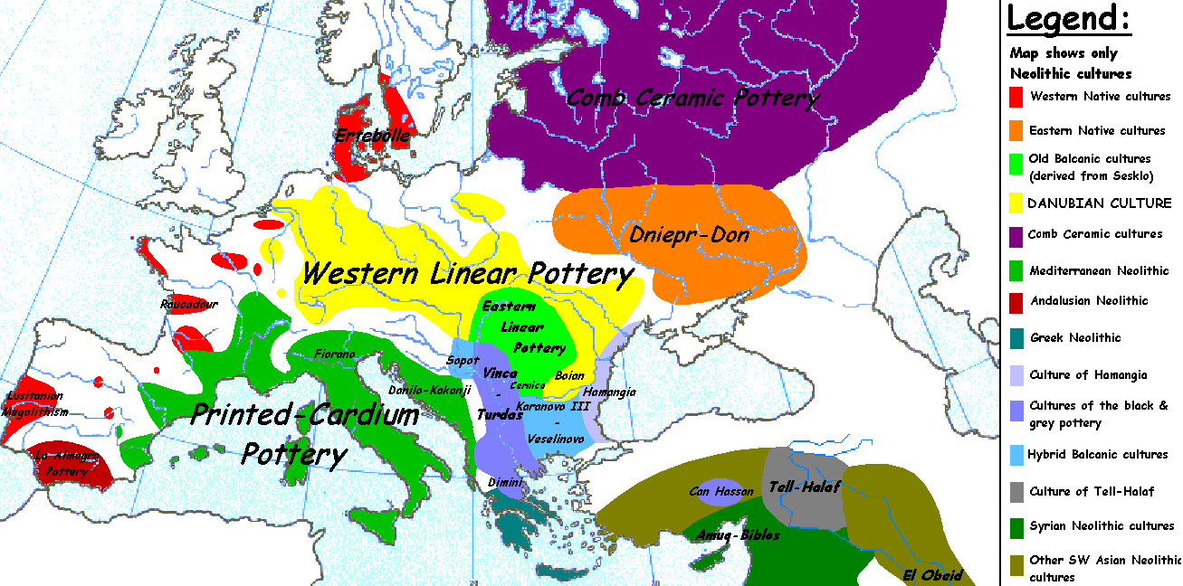
English: Map of the second half European Middle Neolithic at the apogee of Danubian and Mediterranean expansion. (The modification of the original map - Combed pottery, earlier notated as Pitted Ware, see history without respecting the color code of the legend is something that I am not fully satisfied with). |
| दिनांक | ५ अप्रैल २००५ (original upload date) |
| स्रोत | Transferred from en.wikipedia to Commons. |
| लेखक |
अंग्रेज़ी विकिपीडिया पर Sugaar Later versions were uploaded by Clarifer at en.wikipedia. |
| दूसरे संस्करण |
[]
|


_en.png)
.png)
.jpg)
लाइसेंस
| इस कार्य को इसके लेखक, अंग्रेज़ी विकिपीडिया पर Sugaar द्वारा सार्वजनिक डोमेन में प्रकाशित किया गया है। यह पूरे विश्व में लागू होता है। कुछ देशों में यह कानूनी तौर पर नहीं हो सकता है; ऐसा हो तो: Sugaar सभी को इस कार्य का इस्तेमाल किसी भी उद्देश्य से, बिना किसी बाधाओं के इन शर्तों के कानून द्वारा अनिवार्य किए तक करने की अनुमति देता/देती हैं। |
मूल अपलोड लॉग
The original description page was here. All following user names refer to en.wikipedia.
- 2005-08-28 13:11 Clarifer 1320×663×8 (106148 bytes) Added the approximate area of the Comb Ceramic culture. Source: National Board of Antiquities, Finland. www.nba.fi
- 2005-04-05 20:12 Sugaar 1320×663×8 (103228 bytes) Map of the second half European Middle Neolithic at the apogee of Danubian and Mediterranean expansion (c. 4500-4000 BCE). Made by [[Sugaar]]. Free use authorized by the author.
चित्र का इतिहास
फ़ाइलका पुराना अवतरण देखने के लिये दिनांक/समय पर क्लिक करें।
| दिनांक/समय | थंबनेल | आकार | सदस्य | प्रतिक्रिया | |
|---|---|---|---|---|---|
| वर्तमान | 06:43, 18 अप्रैल 2014 | | 1,307 × 648 (101 KB) | Spiridon Ion Cepleanu | Neolithic shorelines and banks, little details |
| 00:39, 22 मार्च 2010 |  | 1,307 × 648 (101 KB) | Ras67 | cropped | |
| 00:50, 14 फ़रवरी 2007 |  | 1,320 × 663 (104 KB) | 32X | Auf eine alte Version zurückgesetzt | |
| 00:49, 14 फ़रवरी 2007 |  | 1,320 × 663 (101 KB) | 32X | Original version by Sugaar. | |
| 11:14, 31 दिसम्बर 2005 |  | 1,320 × 663 (104 KB) | Glenn | Originally uploaded to en-wiki: Quote: "Map of the second half European Middle Neolithic at the apogee of Danubian and Mediterranean expansion (c. 4500-4000 BCE)." Upload text: "20:12, 5 April 2005 . . Sugaar . . 1320x663 (103228 bytes) (Map of the secon |
चित्र का उपयोग
निम्नलिखित पन्ने इस चित्र से जुडते हैं :
चित्र का वैश्विक उपयोग
इस चित्र का उपयोग इन दूसरे विकियों में किया जाता है:
- az.wikipedia.org पर उपयोग
- be.wikipedia.org पर उपयोग
- bg.wikipedia.org पर उपयोग
- bs.wikipedia.org पर उपयोग
- ca.wikipedia.org पर उपयोग
- cs.wikipedia.org पर उपयोग
- da.wikipedia.org पर उपयोग
- da.wikibooks.org पर उपयोग
- de.wikipedia.org पर उपयोग
- en.wikipedia.org पर उपयोग
- et.wikipedia.org पर उपयोग
- fi.wikipedia.org पर उपयोग
- fi.wikibooks.org पर उपयोग
- gl.wikipedia.org पर उपयोग
- he.wikipedia.org पर उपयोग
- hr.wikipedia.org पर उपयोग
- hu.wikipedia.org पर उपयोग
- it.wikipedia.org पर उपयोग
- ka.wikipedia.org पर उपयोग
इस चित्र के वैश्विक उपयोग की अधिक जानकारी देखें।