
चित्र:East and West Florida 1810.jpg
East_and_West_Florida_1810.jpg ((412 × 245 पिक्सेल, फ़ाइल का आकार: 44 KB, MIME प्रकार: image/jpeg))
|
|
यह फ़ाइल विकिमेडिया कॉमन्स से है। वहाँ पर इसका विवरण पृष्ठ निम्नोक्त है। कॉमन्स मुक्त लाइसेंसों के अंतर्गत उपलब्ध मीडिया फ़ाइलों का संग्रह है। आप भी इसमें मदद कर सकते हैं। |
| विवरण |
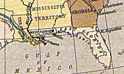
English: Map of East and West Florida in 1810, from the Perry-Castañeda Map Collection [1]. The boundary between the two provinces is incorrect; it was at the Apalachicola River, not the Perdido River (as shown here).
Español: Mapa de Florida Oriental y Florida Occidental en 1810, de la Collección Perry-Castañeda de Mapas[2]. La frontera entre las dos provincias no es correcto; la frontera era el Rio Apalachicola, no el Perdido (como se aparece aquí).
Deutsch: Karte von Ost- und Westflorida 1810. Aus der Kartensammlung der Perry-Castañeda Bibliothek[3]. Die Grenze zwischen Ost- und Westflorida ist unrichtig; die richtige Grenze war der Apalachicola-Fluss anstatt dem Perdido.
Français : Carte de Floride occidentale et de Floride orientale en 1810, provenant de la collection cartographique Perry-Castañeda [4].
La frontière indiquée entre les deux provinces est erronée : elle était formée par le fleuve Apalachicola, et non le fleuve Perdido représenté ici. |
||||||||||||||||||||||
| दिनांक | 1923. Provided on 11 August 2005 by en:User:JW1805 to the English Wikipedia. | ||||||||||||||||||||||
| स्रोत | From "The Historical Atlas" by William R. Shepherd, 1923. http://www.lib.utexas.edu/maps/historical/shepherd/us_expansion_shepherd.jpg | ||||||||||||||||||||||
| लेखक |
|
||||||||||||||||||||||
![[1]](http://www.lib.utexas.edu/maps/historical/shepherd/us_expansion_shepherd.jpg)
|
This work is in the public domain in its country of origin and other countries and areas where the copyright term is the author's life plus 70 years or fewer.
| |
| इस फ़ाइल को कॉपीराइट कानूनों के अंतर्गत सभी संबंधित अधिकारों समेत ज्ञात सीमाओं से मुक्त पहचाना गया है। | |
चित्र का इतिहास
फ़ाइलका पुराना अवतरण देखने के लिये दिनांक/समय पर क्लिक करें।
| दिनांक/समय | थंबनेल | आकार | सदस्य | प्रतिक्रिया | |
|---|---|---|---|---|---|
| वर्तमान | 13:30, 20 अगस्त 2005 | | 412 × 245 (44 KB) | Sebastian Wallroth | '''en: ''' Map of East and West Florida in 1810. From the Perry-Castañeda Library Map Collection [http://www.lib.utexas.edu/maps/historical/shepherd/us_expansion_shepherd.jpg]. '''de:''' Karte von Ost- und Westflorida 1810. Aus der Kartensammlung der |
चित्र का उपयोग
निम्नलिखित पन्ने इस चित्र से जुडते हैं :
चित्र का वैश्विक उपयोग
इस चित्र का उपयोग इन दूसरे विकियों में किया जाता है:
- br.wikipedia.org पर उपयोग
- ca.wikipedia.org पर उपयोग
- da.wikipedia.org पर उपयोग
- de.wikipedia.org पर उपयोग
- es.wikipedia.org पर उपयोग
- fr.wikipedia.org पर उपयोग
- gl.wikipedia.org पर उपयोग
- hu.wikipedia.org पर उपयोग
- id.wikipedia.org पर उपयोग
- it.wikipedia.org पर उपयोग
- ja.wikipedia.org पर उपयोग
- ko.wikipedia.org पर उपयोग
- mk.wikipedia.org पर उपयोग
- nn.wikipedia.org पर उपयोग
- no.wikipedia.org पर उपयोग
- pam.wikipedia.org पर उपयोग
- pt.wikipedia.org पर उपयोग
- ro.wikipedia.org पर उपयोग
- ru.wikipedia.org पर उपयोग
- sco.wikipedia.org पर उपयोग
- sv.wikipedia.org पर उपयोग