
चित्र:Durrani Empire 1747 1862 AD.png
इस पूर्वावलोकन का आकार: 768 × 600 पिक्सेल। दूसरे रेसोल्यूशन्स: 307 × 240 पिक्सेल | 615 × 480 पिक्सेल | 832 × 650 पिक्सेल।
मूल चित्र ((832 × 650 पिक्सेल, फ़ाइल का आकार: 105 KB, MIME प्रकार: image/png))
|
|
यह फ़ाइल विकिमेडिया कॉमन्स से है। वहाँ पर इसका विवरण पृष्ठ निम्नोक्त है। कॉमन्स मुक्त लाइसेंसों के अंतर्गत उपलब्ध मीडिया फ़ाइलों का संग्रह है। आप भी इसमें मदद कर सकते हैं। |
| विवरण |
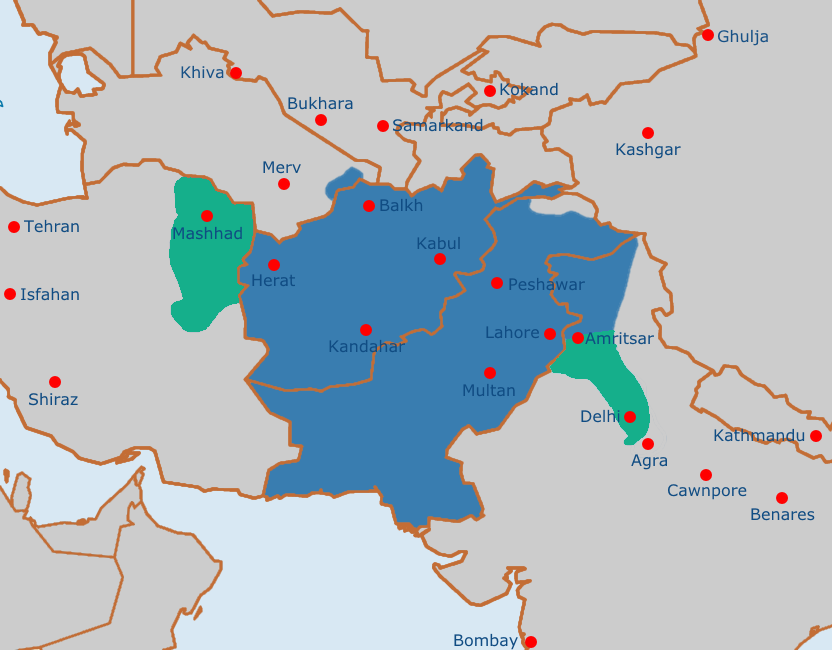
English: Map of the Afghan Durrani Empire at its greatest extent, circa late 1750s. In green is de facto (vassal) control. |
| दिनांक | |
| स्रोत | https://en.wikipedia.org/wiki/File:Safavid_Empire_1501_1722_AD.png |
| लेखक | Arab Hafez and edited by me. |
This file is in the public domain because Released into the public domain by the author.
|
चित्र का इतिहास
फ़ाइलका पुराना अवतरण देखने के लिये दिनांक/समय पर क्लिक करें।
| दिनांक/समय | थंबनेल | आकार | सदस्य | प्रतिक्रिया | |
|---|---|---|---|---|---|
| वर्तमान | 11:51, 4 अगस्त 2021 | | 832 × 650 (105 KB) | Weaveravel | De facto/vessel control and corrected Mashhad/Khorasan |
| 11:39, 4 अगस्त 2021 |  | 832 × 650 (108 KB) | Weaveravel | Improved map layout and scale, added Delhi territory (as de facto control), fixed cities geographical positions | |
| 18:54, 26 जुलाई 2021 |  | 1,415 × 958 (205 KB) | Weaveravel | Clearer, high quality map, more accurate labels and cities (denoting important ones) | |
| 14:27, 28 अप्रैल 2013 |  | 620 × 429 (22 KB) | HistoryofIran | {{subst:Upload marker added by en.wp UW}} {{Information |Description = {{en|Map of the Durrani Empire at it's greatest extent.}} |Source = https://en.wikipedia.org/wiki/File:Safavid_Empire_1501_1722_AD.png |Date = 28. April 2013. |Author = Arab Hafez a... |
चित्र का उपयोग
निम्नलिखित पन्ने इस चित्र से जुडते हैं :
चित्र का वैश्विक उपयोग
इस चित्र का उपयोग इन दूसरे विकियों में किया जाता है:
- ar.wikipedia.org पर उपयोग
- ast.wikipedia.org पर उपयोग
- azb.wikipedia.org पर उपयोग
- az.wikipedia.org पर उपयोग
- be.wikipedia.org पर उपयोग
- bg.wikipedia.org पर उपयोग
- bn.wikipedia.org पर उपयोग
- bs.wikipedia.org पर उपयोग
- ca.wikipedia.org पर उपयोग
- cs.wikipedia.org पर उपयोग
- de.wikipedia.org पर उपयोग
- diq.wikipedia.org पर उपयोग
- el.wikipedia.org पर उपयोग
- en.wikipedia.org पर उपयोग
- eo.wikipedia.org पर उपयोग
- es.wikipedia.org पर उपयोग
- et.wikipedia.org पर उपयोग
- eu.wikipedia.org पर उपयोग
- fa.wikipedia.org पर उपयोग
- fi.wikipedia.org पर उपयोग
- fr.wikipedia.org पर उपयोग
- he.wikipedia.org पर उपयोग
- hu.wikipedia.org पर उपयोग
- hy.wikipedia.org पर उपयोग
- it.wikipedia.org पर उपयोग
- ka.wikipedia.org पर उपयोग
- kn.wikipedia.org पर उपयोग
- lt.wikipedia.org पर उपयोग
- mn.wikipedia.org पर उपयोग
- nl.wikipedia.org पर उपयोग
- nn.wikipedia.org पर उपयोग
- pt.wikipedia.org पर उपयोग
- ru.wikipedia.org पर उपयोग
- sk.wikipedia.org पर उपयोग
- sv.wikipedia.org पर उपयोग
- ta.wikipedia.org पर उपयोग
- tg.wikipedia.org पर उपयोग
- vi.wikipedia.org पर उपयोग
इस चित्र के वैश्विक उपयोग की अधिक जानकारी देखें।