
चित्र:China-Qinghai.png
इससे बड़ा रेसोल्यूशन उपलब्ध नहीं हैं।
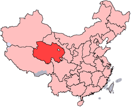
China-Qinghai.png ((268 × 218 पिक्सेल, फ़ाइल का आकार: 15 KB, MIME प्रकार: image/png))
|
|
यह फ़ाइल विकिमेडिया कॉमन्स से है। वहाँ पर इसका विवरण पृष्ठ निम्नोक्त है। कॉमन्स मुक्त लाइसेंसों के अंतर्गत उपलब्ध मीडिया फ़ाइलों का संग्रह है। आप भी इसमें मदद कर सकते हैं। |
en: Location of Qinghai Province in the People's Republic of China. See Locator maps of province-level divisions of the People's Republic of China for more information.
zh: 青海省在中華人民共和國的位置。另見Locator maps of province-level divisions of the People's Republic of China。

|
इस दस्तावेज़ को Free Software Foundation द्वारा प्रकाशित GNU मुक्त प्रलेख लाइसेंस के संस्करण 1.2 या नए (बिना किसी अपरिवर्तनीय अनुभागों और अगले या पिछले आवरण के टेक्स्ट के) के अंतर्गत प्रतिलिपि बनाने, बाँटने और/या बदलने की अनुमति प्रदान की जाती है। इस लाइसेंस की एक प्रतिलिपि GNU मुक्त प्रलेख लाइसेंस नामक अनुभाग में शामिल है। |
| इस फ़ाइल को क्रिएटिव कॉमन्स श्रेय-समानसांझा 3.0 अनरिपोर्टेड लाइसेंस के अंतर्गत लाइसेंस किया गया है। | ||
| ||
| This licensing tag was added to this file as part of the GFDL licensing update. |
चित्र का इतिहास
फ़ाइलका पुराना अवतरण देखने के लिये दिनांक/समय पर क्लिक करें।
| दिनांक/समय | थंबनेल | आकार | सदस्य | प्रतिक्रिया | |
|---|---|---|---|---|---|
| वर्तमान | 14:56, 15 जुलाई 2005 | | 268 × 218 (15 KB) | Schaengel89~commonswiki | transparent background |
| 22:39, 4 जून 2005 |  | 268 × 218 (9 KB) | Ran | '''en''': Location of Qinghai Province in the People's Republic of China. See Category:Locator maps of province-level divisions of the People's Republic of China for more information. '''zh''': 青海省在中華人民共和國的位置。另見[[:C |
चित्र का उपयोग
निम्नलिखित पन्ने इस चित्र से जुडते हैं :
चित्र का वैश्विक उपयोग
इस चित्र का उपयोग इन दूसरे विकियों में किया जाता है:
- cy.wikipedia.org पर उपयोग
- da.wikipedia.org पर उपयोग
- de.wikipedia.org पर उपयोग
- en.wikipedia.org पर उपयोग
- Wikipedia:WikiProject Chinese provinces/Locator maps
- Ledu, Haidong
- Henan Mongol Autonomous County
- Golmud Airport
- Template:Qinghai-geo-stub
- Bayan Har Mountains
- Wenquan, Golmud
- Mangra
- Zêkog County
- Tongren, Qinghai
- Jainca County
- 2008 Tibetan unrest
- Huzhu Tu Autonomous County
- Ping'an, Haidong
- Chengzhong, Xining
- Xireg
- Chengdong, Xining
- Chengbei, Xining
- Datong Hui and Tu Autonomous County
- Huangyuan County
- Huangzhong, Xining
- Hualong Hui Autonomous County
- Haiyan County, Qinghai
- Gangca County
- Menyuan Hui Autonomous County
- Gonghe County
- Tongde County
- Guide County
- Guinan County
- Maqên County
- Banma County
- Gadê County
- Darlag County
- Jigzhi County
- Madoi County
इस चित्र के वैश्विक उपयोग की अधिक जानकारी देखें।